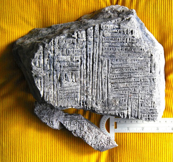
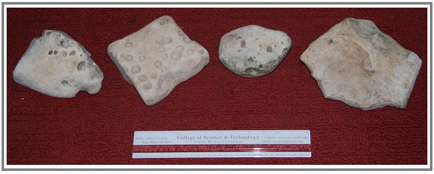
Figure
#1-1a.
Two loose rocks (i.e., stones), both dolomite (i.e., dolostone), that
were
found in rubble in the wash of Lake Michigan at Gros Cap, Mackinac
County,
Michigan. The larger one (top) was found by Caroline B. Cheeseman; the
smaller
one (bottom), by Krista D. Brown. Background is 7-wale corduoroy. For
additional information about their sizes, see Fig. #1-1b.

OCCURRENCE
PATTERNS
ON THESE STONES

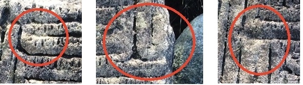
Figure
#1-2a. Features within each of the circles and ovals appear NOT to
resemble
forms known to be natural. (Photo by Caroline Cheeseman.)
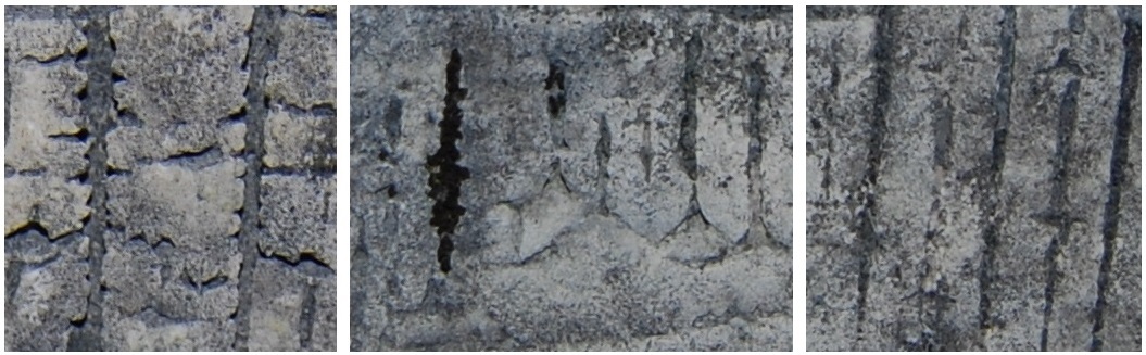
Figure
#1-2c. Close-up to show a few of the diverse edges of the "incised"
lines.
[To
date, no archaeologist or
glyphologist has looked at the specimens ...
In the future, I hope to find one, preferably more than one,
to examine (etc.) these stones.]
Internet
Searches
(by
image & keywords, individually and in
combination) –
[An
aside:
Several images
of each of the following examples are available on the internet. No
particular
reference for any of the examples seems to be more appropriate than
several
others. Consequently, with one exception, citations are not given in
the
following paragraph.]
No
ancient patterns or parts thereof were
found that appear to be more than roughly similar to those on the Gros
Cap
specimens. The following are a few of the obvious differences between
the
patterns on the Gros Cap specimens and those on glyph-bearing stones
that were
among the "hits" that resulted from the searches: Rosetta stone
(dated 196 BCE) -- its characters are fairly well defined and well
aligned. Runestones
(dated 1st to 12th centuries A.D.) – none of their patterns or even
relatively
small parts of those patterns resemble closely the patterns on the Gros
Cap
stones. Early Sumerian Cuneiform
(dated 8,000-3,000 BC) -- some of these patterns, whether "etched" or
"engraved" into rock or, like later cuneiform forms, pressed into
clay, include features that do roughly resemble the patterned surfaces
on the
Gros Cap specimens (see 123RF). Nicaraguan
"petroglyphs"
(dated as 300 BCE) – a few of the "glyph(s)" that adorn the loose
volcanic stones, on the grounds of and within the El Ceibo Museum,
Ometpep (on
an island in Lake Nicaragua), has characters (scale not given!) the
shapes of
which roughly resemble some of those on the larger Gros Cap specimen.
An
"Off the wall" hypothesis for the larger specimen
The
immediate answer to the "each
line or ‘character’ ...” alternative appears to be "NO!" -- This
opinion is based largely on characteristics of the lines (See Figs.
#1-2b &
#1-2c) and also, in the larger specimen, the presence of so much
repetition. [Granted, the pre-weathered and eroded
surface may have exhibited characteristics, now weathered and eroded
away, that
would have indicated otherwise. Also,
even using only the currently available surface, any imaginative story
teller
(I think of my Grandfather Vincent and his reputation along this line)
could,
and probably would, come up with one or more interesting
"translations"(!!),
BUT should one even consider this latter possibility(?).]

[An
Aside: In any case: 1. even if the pattern was
made
to represent some thing/body [and] 2. if it also was, as concluded
herein,
man-made, this stone cannot be designated a mimetolith! Rather, it
would be an
artifact! -- This is so because the pattern that resembles something
else is
apparently NOT a product of a natural processes – i.e., it seems that
it was “scored”
or whatever by one or more human before it was eroded and weathered to
give it
its current appearance!?]
Questions,
Questions, QUESTIONS ! ! !
Possible
Help??:
I
have contacted: Jacob
Dahl, fellow of Wolfson College, Oxford and
director of
the Ancient World Research Cluster. But NO response to date
&
John
O'Shea at the University
of Michigan (email sent 21 Jan 2016). But NO response to date
Holey
stones are said to have been used as anvils to crack acorns and nuts
(e.g., Gray
& Pape, 2016 & Fig. #2-1).
This recorded
use,
plus the fact that several of these stones occur near my current
residence, led
to preparation of this report, which consists largely of a review of
pertinent
literature and a summary of data and my conclusions that relate to the
origin
of holes in the holey stones of the Gros Cap, Michigan,
area. The literature review, especially that relating to origins
suggested for the formation of the holes in these rock, differs from
that usually given in reports in that it
includes -- indeed , so-to-speak, emphasizes -- "hypotheses" recorded
by non-scientists on internet web sites.

Definition: Holey stone, as used herein, is
any naturally occurring stone (i.e., loose rock) with openings,
typically at
least roughly circular, into or through them.
This
definition is strictly descriptive -- i.e., no origin (other than
its being of natural occurrence), use, or any attribute of these stones
is
included or implied (see following paragraph.) In addition, this
designation
does not require any of the holes in a so-named stone to extend all the
way
through the stone; this is mentioned because the term has been
so-restricted in
some publications (e.g., Niagra, 2015 ).
Names given to
specimens, which are illustrated and/or described in the literature
(including
internet entries), that closely resemble the Gros Cap specimens are
referred to
by many terms. Several of those designations, most of which are
binomial (i.e.,
an adjective plus the word stone or rock) may be tabulated according to
their
usual connotations as follows:
Shape
important: cupstone*I, holey stone, pitted cobble*I, ?Poculolith?*,
Shape
& use important: anvil stone*I, nutting stone*I,
Shape & origin important: anvil
stone*, cupstone*, holed stone*, nutting stone*, pitted cobble*,
Poculolith*I
Legend-related:
crick stone, faery (or fairy) stone, hag stone, hex
stone, holy stone, mare stone (some only), Odin (or Odin’s) stone,
Tafoni
(tafone-singular), witch stone (or Witches amulet).
The
asterisks (*) indicate dual listing. The
hands (I) indicate stones the holes of which have been shown or
believed to have been man-made (e.g., Davis, 2002).
Some of those so-called man-made holes,
however, seem more likely to represent only modification of originally
natural
holes so they would better fill their desired function. [Indeed, an
associated
aspect about which I have often wondered is:
Do “concentrations” of holey stones, such as those at Gros Cap, indicate
that these places were where a few or more people came together to use
these
stones?.
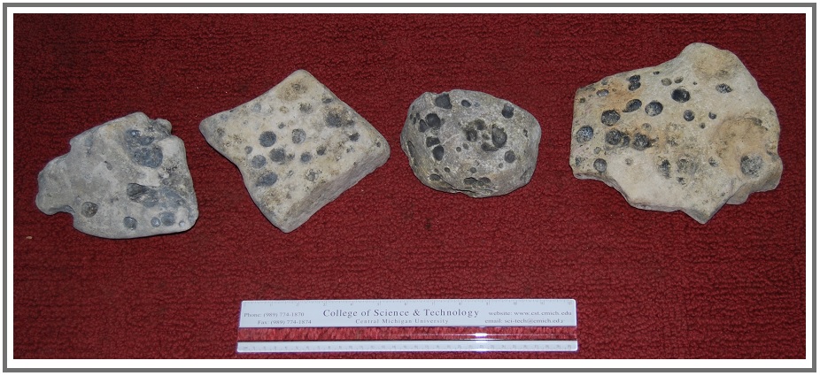
Gros
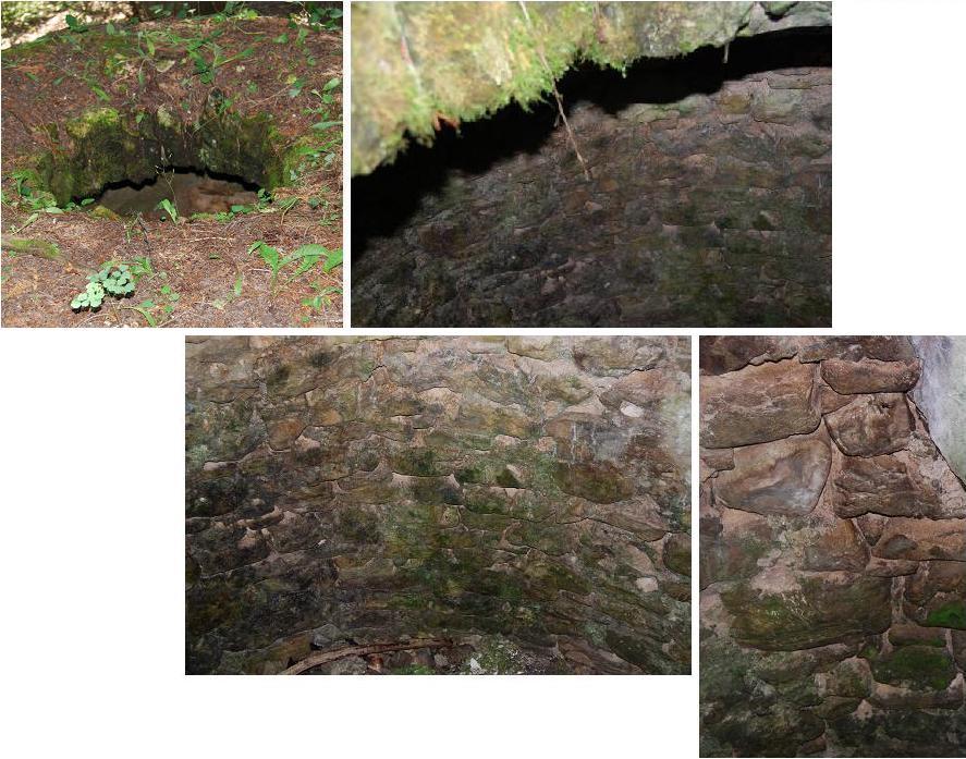
Cap Stones: Four
of the
holey stones that were among onshore rubble or awash Lake Michigan near
Gros
Cap Road, Mackinac County, Michigan are shown in Fig. #2-2. This location, at 45o53'41.89"N - 84o50'25.11"W
(elevation
of 581 feet), per Google Earth, is about a 0.25 mile southwest of the northern junction of Gros
Cap Road and
Route 2, which is approximately six miles(atcf) west-northwest of Saint
Ignace,
Michigan.
A.“Rock-boring
clams” – The inclusion of this designation in quotes, is used to
distinguish boring from burrowing clams (see Stanley, 1970, p.8). Rocks and stones with holes of similar shape
and size as those shown in the included photographs have been reported
to occur
in numerous places here and there around the world, and many have been
seen or
concluded to have been formed by “rock-boring clams” (e.g.,
those of the family Pholadidae – see,
for example, [+++++see
Frey(1975), Miller(2007), and
Seilacher(2007)]. ß
Although this
origin seems best to fit the features of the Gros Cap holey stones, the
fact
that all recorded “rock-boring clams” live in marine or brackish
environments
is problematic so far as fitting the probable geological history of the
holey
stones of this area; this matter is
treated under the Problems/Questions subheading. <-- Considering
range of these critters
per Wilson
and Palmer, 1988,
IF
holey stones are found in Mac Breccia, this “problem” disappears!
Dick: The one feature I mentioned before to check
is that pholad boreholes are not columns, i.e., having the same
diameter from
top to bottom, but rather they taper, being narrower at the top, and
wider at
the bottom as the clam grows. Reed, virtually all of the holes in the Gros
Cap specimens appear to have just the bottoms of such holes (or perhaps
just
the so-to-speak “starts” of such holes – indeed, this latter
possibility may be more likely, ESPECIALLY
if the rocks
were attacked after becoming loose; I
just do not know what strata were atop or below the strata in which the
depressions occur. I do, however,
specimens with holes of different sized holes, be they the tops or
bottoms of
such boring activities. So? ?
4. Erosion
by “surging
water” -- “… the many deep pores and holes are a
result of the
repeated surging of water on limestone across a long
period.” (Hauser, 2014).
ß
No information is given, or seems likely
to exist, that appears to support this suggested mode of
formation.
5. Physical
and/or chemical processes promoted by activities of humans or other
primates
-- This hypothesis has the holes formed as the result of countless
impacts
(i.e., poundings to crack acorns and/or nuts) with these stones
functioning as
the anvils. The physical and/or chemical processes indicated to
have been
involved are abrasion and actions of solutions indicated to have been
derived
from the crushed acorns/nuts. Add
citation ß This hypothesis seems unlikely for several
reasons: Granted, walnut shells, for
example, are sometimes used as an abrasive, but only to polish such
things as
mortar; [and] crushed acorns have been
used as a source of tannin, which is acidic, but it is an extremely
weak
one. In addition to have any effect, each hole would have had to have been a locus
where an
extremely large number of acorns/nuts were placed and cracked
Problems/questions [[This whole section may become superfluous if similar stones are found in the Mac breccia!!! – but it may be worth summarizing the problem as a comment re possible post Michigan Basin fm of any such holes in rocks??!???]]: What creature(s), if any, formed the holes in the Gros Cap stones?
Dick: That is probably the
best way to put it. Fresh-water clams do
go back as far as the Middle Devonian, according to Boardman. Boardman also said “some infaunal pelecypods
bore into hard substrates, including rock, coral, and wood” but he
doesn’t say
how far back that goes.
In
any case
:
As already mentioned, the holes seem to have been made in the rock
since it was
lithified -- i.e., since its parent sediment was turned into rock. And, at least some of the holes seem almost
certainly to have been formed after fragments of the rock had been
broken loose
from their original strata – i.e., when both their originally top
and
bottom surfaces so-to-speak alternately became prone to attack. This is
confirmed by the presence of similar holes on both sides of some of the
subprismoidal stones -- see especially the specimen that is second from
the left
in the above photographs. ß IF
this
conclusion is correct, a possible history of the Gros Cap stones in
which the
holes occur would probably have included the following steps, which, by
the
way, are consistent with the widely accepted geological history of the
region: Deposition of the parent
sediment during the Silurian [[ß Is any of it of
early and middle Devonian age?? – if so, change the text AND
the following datesà]] (i.e., ~415 to 445 million years BP);
lithification
of that sediment; relatively deep burial;
uplift and exposure of these rocks to the elements (perhaps
more than once -- note
pre upper Devonian karst period,
formation of Mackinac Breccia, etc. and hypothesized deltaic upper
Devonian; “for good” exposure, perhaps
before or near the end of the Paleozoic – i.e., ~150 my B.P. [but what
of Jurassic – is it marine
or non-marine??; and whichever, is it restricted to middle of basin(?)]
; --
in
any case, certainly before the Pleistocene -
~2 my B.P. -- Can
preceding
be summarized as in following parenthetical …?? (probably
near the end of the Paleozoic (i.e., ~150 my B.P.), and certainly
before the
Pleistocene (~2 my B.P.) --------
Dick: Probably summarize it
as you’ve done in parentheses. As we
discussed, I don’t know how far back rock-boring clams go.
The Treatise has the Subfamily Pholadinae
only going back to the Cretaceous (p. N707).
Of course, these could be Pleistocene-Holocene fresh-water
boring clams,
if fresh-water boring clams exits.
IF,
however, holey stones are found in the breccia, that will require
several Major
changes in above text!! And It will
even:(!!): raise additional
questions such as: Were any of the described and
similar specimens wxed out of the breccia(?) -- Very likely, YES!! When(?) & Were the
conditions when the caves, karst, etc. that existed when the source
rock/debris
of the breccias were formed and accumulated such that the included
holey stones
had already been subjected to non-marine environments and processes(?), OR, perhaps they would have been
formed in
marine conditions BUT, if by rock-boring clams, that would extend their
range
back to pre-late Devonian!!! , etc. Qre
this last item, statements would then be appropriate re fact that dates so far as
information given in
the Treatise… suggests that boring clams, although known to have lived
in
locations here and there the world over, have not been recorded in
strata older
than Mesozoic -- ((The one noted as
questionably Carboniferous seems to have been a burrower rather than a
boring
clam.)) BUT all of that more likely indicates
that I am unlikely to find any holey stones in the Mackinac Breccia; nonetheless, I SHALL SEARCH!!! & and make
a point to note that such as been done with whatever the results are AND, it
also would be worth at least mentioning that the refs from Reed do
indeed indicate that the holes were formed
no earlier
than mid-Mesozoic – i.e., when the northern part of MI Basin was no
longer (or
later) under marine or even brackish waters. etc. Whatever,
e, all of this could lead to some
so-to-speak convoluted possible histories of these rocks/stones and
even of at
least this part of the Michigan Basin, … .
The
following aside may not be needed
or need revision IF holey stones are found in the Mackinac Breccia!!! [An
aside: If the
holes in these stones were formed by any animal, the holes would be
ichnofossils – i.e., “trace fossils.” However, unlike more
typical ichnofossils,
these were apparently made much later than the rocks in which they
occur.
That is to say, rocks which are more than [400,ßrevision
to be needed?!!] my
old contain
ichnofossils made by life forms that lived as recently as the last few
thousand, or perhaps only the last few hundreds, of years.
Consequently, these
ichnofossils, and perhaps others of this general nature would not have
the same
value – e.g., for dating their host rock – as most fossils do.]
ALSO
NOTEWORTHY:
1. Roughly similar stones have been recorded
from
several regions the world over. Numerous
photos, locations where these stones have been found, etc. are
available
on-line; search – using, for example,
”holey
stones” -- Google Images.
One relatively nearby
occurrence includes
photographs of a few of these stones that were "gathered on the beaches
along the north shore of Lake Superior near Grand Marais,
Minnesota" (Still
Blog, 2012).
2. Re
when the holes of
some of these stones may have been used as anvils, see those found in
Adams
County, Ohio and recorded as so-used;
this uses is recorded as "Dating to the Late Archaic period (ca.
8000-1000 B.C.)." (Gray &
Pape, 2016). See also Figure #2-1: This photograph was setup in 2015 A.D.; it should not be construed to indicate this
use either to be or not to be current.
ACKNOWLEDGMENTS: Krista D. Brown helped
collect some of the
described and studied specimens. [Jessica M. Winder
provided an opinion.] Reed
Wicander,
Kurt R. and Richard S. Dietrich read and criticized different drafts of
the
manuscript, and Dr. Wicander also supplied not otherwise readily
available literature.
David D. Ginsburg formatted the cited
references. I gratefully acknowledge
these contributions.
REFERENCES CITED
Boardman, R.S. (senior editor),
A.H. Cheetham and
A.J. Rowell (editors). 1987. Fossil
Invertebrates. Palo Alto(California):
Blackwell Scientific Publications:
Conjured Cardea. n.d. “Hag
Stone-Holy Stone-Fairy Stone-Witch Stone-Protection from the Evil Eye,
Nightmares, Spirits, Misfortune-Key to the Faerie Realm”. <http://conjuredcardea.indiemade.com/product/hag-stone-holy-stone-fairy-stone-witch-stone-protection-evil-eye-nightmares-spirits-misfortu>.
Internet; accessed 2
January
2016.
Culbreth, Steve. n.d.
Forensic Paleo biology: holey rock of Texas. Dinosaur Home:
< http://www.dinosaurhome.com/forensic-paleo-biology-holey-rock-of-texas-806.html>. Internet; accessed 14 November 2015.
Davis, A.B. 2002.
“Cupstones of Adair
County, MO”. Missouri Folklore Society. < http://missourifolkloresociety.truman.edu/cupstones.htm>.
Internet; accessed 14 January 2016
Deneki Outdoors. 2014.
“Holey Rocks”. <https://www.deneki.com/2014/12/holey-rocks/>.
Internet; accessed 18 November 2015.
Gray &
Pape. 2016. “How Do You Crack a Nut?”. <http://graypape.com/how-do-you-crack-a-nut/>.
Internet; accessed 31
January 2015.
Miller, William, III (editor). 2007. Trace
fossils: Concepts, problems,
prospects. Amsterdam,… :Elsevier.
Stanley, S. M. 1970.
Relation of shell form to life
habits of the
Bivalvia (Mollusca). Geological Society of America, Memoir 125.
Boulder
(Colorado): Geol. Soc. America
Still Blog. 2012.
“collection of rocks
with small holes”. <http://stillblog.net/collection-of-rocks-with-small-holes/>. Internet; accessed 10
November 2015.
Towrie,
Sigurd. n.d. “The Odin Stone”.
Orkneyjar. <http;//www.orkneyjar.com/history/odinstone/>.
Accessed 31
December 2015.
Wilson,…
and … Palmer. 1988. Which one??
Winder, J.M.
2013. Jessica's Nature Blog. <https://natureinfocus.wordpress.com/>.
Internet;
accessed 7 January 2016.
Is
Pacific Biological Station,
British Columbia worth a contact?? To
see, for example, if they know of freshwater rock-boring clams …
What
about --
I believe there is a similarly
directed group at U of Cal at Santa Barbara.
LITERATURE INFO to check/use:
P188
– mentions other borers: “Bivalves,
polychaetes, sipunculids, and
other groups bore terrigenous rocks … and galatheid crabs excavate …”
P192
-- “Separate groups can produce very similar
borings.” Note that some
paleontologists refer to this as bioerosion.
Seilacher,
Adolf. 2007. Trace fossil analysis.
Berlin, …:Springer-Verlag.
Borers: crabs,
clams, worms techniques of burrowing are given – I am NOT
interested in them unless dealing with patterns that result from those
techniques.
--The diagrams are
okay,
BUT This is one of those places -- And I think such
is for many things (e.g., rocks) often more misleading than helpful!!
-- that I think photo matching might be a better tool (!).
Wilson and Palmer.
1988 - Search on Google, using Wilson,… and …Palmer. 1988
will, I think, get to one to the info needed; then Search within
for Corallidomus and Ordovician. IF not available on line,
I need to get the article.
Following is copy from PDF of Miller, p.362:
Question: were holes are
in wood or rock or unconsolidated sediment?? – probably not wood
considering date!!!!!!
D: Things to
do/consider/rewrite IF:
1.Search for these stones in Mac Breccia.
2. If any are found, Consider when holes were bored – e.g.,
a.during
sedimentation – not likely with holes in both tops and bottoms of
strata/stones
b.post
lithification!!!
Post breaking of layers off so they could be attacked on exposed
surfaces! SO –
3.What were conditions from then to time they were incorporated
into the Mac Breccia?? -- Note, for example, conditions
(non-marine, even continental -- needed for karst topog, widely thought
necessary for fm of the breccia. ((Such might require, and at
least would be a good place to mention the fresh- vs marine- water
habitat info for boring clams)) [[AND, IF holey stones are not found in
breccia, be sure to note that that absence does NOT necessarily
preclude some being there at other places -- my sampling will be
somewhat limited because of lack of outcrops, difficulty in getting to
some of those known to exist, ... !!]] ALSO, if not there,
mention likelihood that post Mac breccia formation(time) the area was
apparently under terrestrial or near such conditions at least much of
time --- e.g., next overlying rock is the Engadine fm., widely
considered to be of deltaic/estuarian/… deposition, etc.,
etc.
“Though
they [i.e.,
A-tents] form only a minor structural and topographic feature, they are
rather
unusual
and the interest
attaching to them is out of all proportions to their
size and frequency.”
(H.P. Cushing , 1910)
INTRODUCTION
An A-tent, previously only mentioned in an obscure
publication (Dietrich,
2008, p.61) and apparent modifications of a nearby A-tent, which was
first
recorded more than a century ago (Cushing et al, 1910, p.115) are
described.
Questions and comments that arose as these descriptions were recorded
are
noted.
DESCRIPTIONS
INFORMATION COMMON TO
BOTH A-TENTs.
PETROGRAPHY of the Potsdam Sandstone within the area is described by
Buddington (1934, p.179) and Dietrich (1957, p.101). The strata
involved are
silica-cemented sandstone the sand of which consists of 99-plus per
cent
medium- to coarse-grained quartz sand. A
few lamellae consist largely of hematite-coated grains. The
strata involved in these two A-tents are
similar.
STRATIGRAPHIC
POSITION. The stratigraphic relations and information about the
variable thicknesses of the Cambro-Ordovician Potsdam Sandstone of the
area are
described by Cushing (1916, p.32 et seq.).
DATE OF
FORMATION. A post last glaciation of the area date for the formation
of these A-tents is indicated by the presence of the glacial striae and
chatter
marks on the upper surfaces and the absence of such features on the
other ,
surfaces of the blocks of these structures. [[??>>
Because basic assumptions upon which
such "blanket" names as Nebraskan and Wisconsinan have subsequently been concluded to lack
their originally assigned application, none of these names is used in
this
note.
<<??]]
HADLOCK
A-TENT. This previously undescribed
structure
is called the Hadlock A-tent in this note.
Edwin C. Hadlock (d), then owner of the field in which the
structure
occurs, directed my attention to it in 2007, when he was taxiing me
within the
area during a geological reconnaissance study of the Hammond township
(Dietrich, 2008) .
BETTER PHOTO to come!!!!
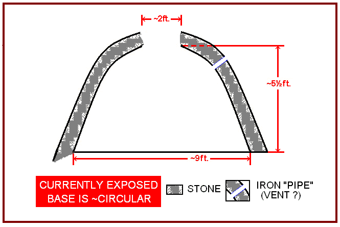
This A-tent (see
Fig. 5 #1) is located
a few meters west of Route 37, 1.8 miles north of Hammond village. It consists of two, continuous sections,
each of which has a virtually straight axis; the
strikes of these axes differ by ~!0
degrees. Dimensions and descriptions
follow:
Location: across Route 7 from the junction of Hadlock
Road (i.e.,
at ~
44°28'22"N; 75°40'58"W; elevation ~341ft.MSL). [This
A-tent is ~ 5.4 miles, northeast the
Cushing A-tent.}
Strike
of
axes: Southern part – N35E;
Northern part – N25E (i.e., 35º
and 25º, respectively)
Height
of apex
above level of surrounding surface: up to ~1m. ( = ~3 ft.)
Length of structure: Total
of two segments -- 53m. ( = ~175
ft.)
Southern part – m. ( = ~X
ft.)
Northern part – m. ( = ~X
ft.)
Width
of
structure: 4.6 m . ( = ~15 ft.) [[
<chk are
both parts of same width? AND
THIS
needs more measurements and explanation. ]]
Sizes
of blocks:
Southern
part – Largest: 0.75 x 1.65 x 0.23 m = ~
0.28 meters3 weight? ( = ~ 2½
x 5½
x
¾ ft. =
~ 10¼ feet3 )
(delete
this one? -- One of
smaller ones: yy x yy x yy)
Northern
part -- Largest: 2.3 x 4.4
x 0.2 m
( ~ 2 meters
3) weight? ( = ~
7½ x
14½ x
2/3 ft. (
~ 72.5 feet3 )
.
(delete
this one?? -- One of
smaller ones: yy x yy x yy
1. chk
>>(if none, say so)>. Glacial
striae and percussion marks are on
original, neay horizontal tops of blocks but NOT on their other
surfaces.
2. The “cross joints” -- i.e.,
the broken surfaces of the blocks that are at a high angle to the axis
of each
of the two segments of thIs structure are approximately perpendicular
to their
respective axis.
3. The block on one side of the axis of each segment overlaps
its opposing block. AND, with exceptions,
each
overlapping block adjacent to a block that is overlapped from the other
side of
the axis (Fig. 5-#2; cf. Cushing et al.,1910,Fig.10, p.116). <<
D:– give photo to show and label as Mortise and
Tennon arrangement.;
4. Really
look at junction area, and describe here.
Get
photos of “junction" area IF POSSIBLE!
5. (
IF exposed, MEASURE STRIKEs and DIPs OF NEARBY
JOINTS!!; IF not, perhaps(??) cite
diagram in Brier Hill report. )
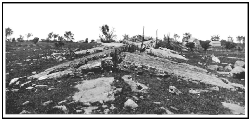
This A-tent (see
Fig. 5 #2) is about 3.9 miles southsouthwest
of Hammond village – i.e., about 1.8 miles south of Chippewa Bay. Dimensions and descriptions, along with
comments about modifications it has undergone during the last hundred
years,
follow:
Location:
southwest
of Webster Road, ca. 0.15 mi. from its junction with Callaboga Road (i.e.,
at ~ 44°24'51"N; 75°45'25"W; elevation
~361ft.MSL). [And, as already
noted, this A-tent is ~ 5.4
miles, southwest the Hadlock A-tent.}
THIS FIRST ONE, IN PARTICULAR NEEDS
RECHECKING!!!!!
Strike
of apex: N.72E [per Cushing: N.28W] respectively -- 72º and
152º
Height
of central
part of apex above surrounding surface:
~ 1.8 m. ( = ~ 6 ft.) [per
Cushing: about 12 ft.]
Length
of
structure: ~ 41 m. ( = ~ 45 yds) [per Cushing: 40 yds]
Width
of structure
(i.e., between edges of blocks on opposing sides):
~13m. ( = ~ 14 yds/~ 42 ft.)
THIS needs more
measurements and explanation.
DELETE FOLLOWING??
One of smaller ones. ~3.5’ x 3.5’ x
0.5’
1. As already mentioned,
glacial
striae and sporadic chatter marks are on the original tops of blocks
but NOT on
their other surfaces.
2. The “cross joints” -- i.e.,
broken surfaces of the blocks that are at a high angle to the axis of
this
structure -- are approximately perpendicular to the axis.
3. Only a few of the
broken surfaces that so-to-speak define the axis of the structure
overlap as
indicated by Cushing (Cushing et al.,.1910 - p.116, Fig.10) -- instead,
nearly
all of the blocks that are on the northwestern side of the apex overlap
the
blocks on the southeastern side -- (see
photos Calaboga 8&9).
However, considering the fact that Cushing's indicated height of
the
apex is significantly greater than it is now (2007), the following
question and
comments seem noteworthy; they possibly
explain
this possible discrepancy in Cushing’s and the recent observations. Have the blocks moved outward from the axis -- i.e., undergone post-formation partial
collapse?
since Cushing mapped the structure in the early 1900s? -- One or more
of the
following activities may, in fact quite likely, have occurred and would
support
an affirmative response: a.
Trees have grown in the axial since
Cushing's observations -- (see
Fig. Calboga 9). (Tree wedging –
e.g., see Dietrich (1957, p.21, Plate 6) -- provides permissive support
so far
as their having a causative role for such movements of the blocks.) b.
The surrounding, nearly flat bedrock is exposed on the southeastern
side of the
structure whereas the other side is covered by soil.
(Slipping atop the exposed rock, possibly
enhanced by seasonal ice buildup would tend to be away from the apex; this would
result in the apparent change in height and possibly also the apparent
differences
in the character of the overlapping relationships along the crest of
the
structure.
4. (Measure/record
Strikes & Dips of nearby Joints!
)
ORIGINS
The two
A-tents may have similar or different origins; this is true so far as
both the pre-formation
conditions of the rocks and/or the causative triggers (see COMMENTS …). No origin has been or is herein suggested for
the Hadlock A-tent. Several comments
about the possible origin of the Cushing A-tent are in the literature
(e.g.,
Cushing in Cushing et al, 1910; Twidale
and Bourne, 2005; Jacobi
et al., 2007).
Two
considerations indicate that only a comment ( i.e., NO conclusion)
about the an
origin should be given in this note -- 1.
No data (i.e., values) relating directly to the stress --
internal/residual/compressive
-- of the sandstone of either of these structures or the surrounding
rocks are
available. [and] 2. Two seemingly
significant references--
i.e. Dames and Moore, 1974 and Smith, 1977 -- that pertain directly to
the Cushing
and other nearby A-tents have been unavailable, even via ILL.
The comment
is: Changes of conditions -- for example
those that accompanied deglaciation and/or post-last glaciation
isostatic
rebound -- may have had major roles in both the buildup of internal
stresses
and their release, which may have been abetted by “triggers,” that
caused
buckling and formation of these A-tents
((That comment is based largely on impressions gained from a.
data recorded in this
note; b.
a review of the
vast literature relating to A-tents and the pertinent tectonic domain
of the
region; [and] c. considerations relating to
Lowry’s (1959) and my (1961) investigations of the Mt. Airy “granite”
and
subsequently determined residual tress information obtained for that
rock by
overcoring procedures employed by the U.S. Bureau of Mines personnel,
which
were concluded to be conditions “ripe” for formation of additional
buckles at
the quarry.
((To elaborate, the following thoughts have arisen in my
mind several times since I again saw the Cushing A-tent and had my
attention
directed to the Hadlock A-tent:
((The axes
of these A-tents have different strikes; in fact, the Hadlock structure
has a bipartite,
albeit continuous, axis -- the two parts of which have different
strikes. And, none of these strikes
appears to fit
into a pattern or correlate with the current regional – granted, less
than
well-established – regional tectonic/stress pattern.
((The
structures were formed after the last glaciation -- i.e., after the
load of
glacial ice, plus or minus debris, was removed -- and during the
subsequent,
still on-going, isostatic rebound.
((The
so-called “trigger,” could have been instantaneous or have been a
"slow-trigger" -- i.e., a gradual change in the position and
condition of the rock until a critical condition was exceeded. Two examples might be only the removal of the
removal of the glacial ice and its load and/or when subsequent
isostatic
rebound reached a critical level – i.e., where a release of the
compressive
stresses within the rock occurred and one result was formation of one
or more A-tents.
((--- Of
course, no stress measurements for rocks of either A-tent or of nearby
equivalent strata are known, and cannot be determined for the time of
formation
of these A-tents. However, if current
measurements of the internal stresses of the rocks of these structures
and of
the surrounding rocks are made, possibly those data could be programmed
to give a model whereby one could at least determine their approximate
previous conditions and even how these
A-tents were formed, whther with or without a trigger per se or even
with a
“slow
trigger.” -- See paragraph XX
in the following Comments
and Questions section.))
As I typed
the above comment plus, which some readers may consider a conclusion,
two old
“saws” came to mind: “Fools rush in
where wise men fear to tread.” and “There’s no fool like an old fool” (I am 92
years old).
It seems
prudent to preface the following paragraphs with a disclaimer: Because of my lack of access to some of the
publications
I should review, I urge readers to insert So far as I know
before each
of the following paragraphs.
The first five
paragraphs relate to the
possibility that burial beneath thick glacial ice had a role in the
formation
of these A-tents.
No
A-tent in this region has been
recorded as having been formed before the last glacial epoch. Does this mean none was formed? OR Were
such A-tents, if formed, disrupted and their parts moved and thus not
recognized as such? -- So
far as the first question, three things may
have precluded their earlier formation:
1. Strata susceptible to disruption and formation of A-tents may
not
have been at or near enough to the surface where they could form. 2. During earlier glacial and interglacial
epochs
the strata were not buried deep enough to gain an internal stress
condition
required for the release and formation of A-tents.
3. Whatever the depth of burial by the
glacial ice (etc.) and the resulting condition of the the strata, the
subsequent
rebound was insufficient to change the environment where such would
happen during earlier interglacial periods. And,
of course, some combination of these
possibilities plus other things might have been effective controls. In any case, IF either the second or third
possibilities prevailed, they would have implications so far as
reconstructing
the Pleistocene history of the region.
To
continue that line of thought: Was the
glacial ice plus its load during the
last glaciation of this region thicker, and thus heavier, than that of
earlier
glaciations? If it was, the downward
depression of the Potsdam Sandstone that constitute these A-tents would
have been
buried
deeper than during preceding glaciations, compressional stresses built
up within
the
buried rocks could have been greater, and consequently the post-glacial
isostatic
rebound, which is still occurring, would have caused those rocks to
have undergone greater changes
than
those to which the rocks had been subjected in response to earlier
glaciation
and rebound “cycles.” In addition, the current
bedrock surface may not have been at or even near the surface before
the last glaciation. [Along this line,
what is really known about the thicknesses of the last continental
glacier
within the region and of earlier Pleistocene ice sheets that covered
the
region? Are dates indicating their
longevities really indicative? Even if they are, is there any known
correlation between
durations
of continental glaciations and their thicknesses(?), of
the amount of erosion they caused(?), ...?
Is the distance that the different glacial
ice sheets extended southward related to their "up-stream"
thicknesses? Does the size and
distance
of travel of erratic boulders during any given glaciation have a
relationship to the thickness of the glacial ice(?) to the speed of
movement of the ice and its load(?), to the amount of erosion caused by
any given glaciation(?) …
Could
fatigue have been involved? -- That
is, is it possible that more than
one depression (for this region, multiple periods of glaciation) and
rebound
had a role, or perhaps was even required, for the formation of the
A-tents
in
these rocks. [This question is prompted
by changes and effects known to be involved in breaking, for example,
metal sheets,
rods,
etc. – i.e., those that break only after having been bent and
straightened
several times.]
Could
the occurrence of these A-tents
indicate that the strata involved were only finally thinned enough by,
for
example, the last period of glacial abrasion, to the point that they
could no
longer retain their integrity – i.e., to the point they could be bent
and broken
to relieve the residual stresses within them .
[If this was a control, it seems likely that it must have been
only a
subsidiary control; among other
things,
the thicknesses of the strata involved in the Hadlock and the Cushing
A-tents
differ markedly, AND several extensive areas with thinner, apparently
similar
Potsdam Sandstone strata as exposed bedrock with no A-tents occur
within the area.]
Are
more A-tents likely to be found
with the area? This possibility came to
mind because of an inquiry of a geologist who read this manuscript and
reminded me that both A.F. Buddington, who mapped the area, and I, who
lived in
the area for many years and mapped an adjacent quadrangle, were
basically
hard-rock petrologists, and consequently may have had our minds on
other things as we passed the Hadlock A-tent. --
I feel sure that "Budd" did not see it, or he would have told
me; I know that I did see it even though I drove past it hundreds, if not thousands, of times. I first saw it when the
landowner
took me to see it in 2007, more
than 65
years after I first drove past it IF it was there. [The
"IF ..." is based on the possibility that it was formed
sometime
between about 1952 and 2006. I shall continue to
question people who might have information that would preclude or
support this possibility.]
The following
comments include a maxim, a
wonder, and “triggers”.
A-tents can only form where a
sufficiently large "open space" is present in direct contact with or
relatively close to their constituent rock formation -- i.e., a space
into
which the rock can "burst."
Therefore, the presence of an A-tent can serve the same role as
an
unconformity so far as interpreting geological history.
One
wonders if the fact that the Hammond A-tents are on so-to-speak high
areas had
any effect on their formation. – The Cushing A-tent is on a “high”
between the St.
Lawrence River and Chippewa Creek valleys; the Hadlock A-tent is on the
"high"
between
the Chippewa Creek and Black Lake valleys.
TRIGGERS:
DETonations
– Nearby blasting could change conditions, perhaps only by slightly
jarring, a
rock in its near-critical condition and thus trigger formation of an
A-tent.
Time of its formation appears to preclude this possibility for the
Cushing
A-tent, but perhaps not for the Hadlock structure.
EARthquakes –
These, like detonations, may cause and/or be the
result of
the formation of A-tents such either, neither, or both of the A-tents
considered in this note, and also of other
A-tents. A recent example is one that formed near Menominee, Michigan
in
2010.
ENCircled
……
– This,
apparently “far out” possibility came to mind during the 2014-15 winter
when I
observed the formation of an A-tent like structure formed of
surficial and near suface ice in a bay near the northern shore of Lake
Michigan.
It appears to have formed when a volume of “buttressed”
ice had
expanded to the point that it became too large for the confined space
that
it
occupied. Granted, that feature apparently formed as a consequence of
the
expansion that occurs when water is frozen to ice within a confined
space. And,
rocks tend to have their volumes reduced, albeit only slightly, when
cooled but what about rocks that
have high porosities (and permeabilities) when they are saturated??
METeorite impact – A true trigger, and
it seems possibly a cause, wherever a meteorite might impact rock, the
condition of which was at a critical state so far as becoming an A-tent. Along this line, it might be worthwhile to
search for meteorites in the vicinity of A-tents!?!?
AND, If it is possible to search within the
open-space beneath the blocks of an A-tent, one should also look for
shear
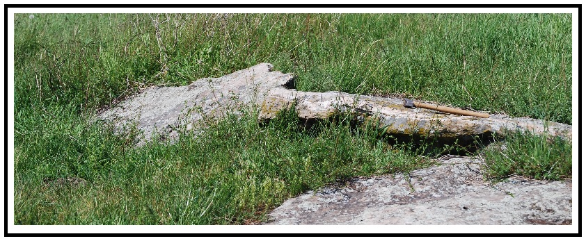
cones (see Lowry, 1959, p.1; and Dietrich, 2008, cover 3). What
about the guy who gave me the latter?? Contact
him through Donna/Nancy? – I need to
know if that one was made by man-imposed percussion or if perhaps there
is an
A-tent where he found it !
SHEeting
of, for example, underlying granite -- Could
sheeting of an underlying formation, whatever its cause, act as a
direct "trigger"(?). or perhaps so act indirecty by furnishing open
places into which water could get and freeze and expand? [So far
as
the two A-tents described in this note, it seems quite possible that
granite
that exhibits sheeting is beneath the sandstone of the Cushing A-tent,
and the
identity of the rock beneath the sandstone of the Hadlock A-tent may be
the
same, but is less predictable. To date I have found no pertinentt well
driller's data.]
THErmal
insolation (Would it be better
to call this a condition?? As a possible
trigger,
this one is of special interest to me for two particular reasons: 1. This possible trigger reminds me of one of
my favorite phrases in geological “literature,” one I first found in
the early 1950s – i.e., “horizontal expansion of
superficial
strata, consequent on postglacial amelioration of climate“ (Gilbert, 1887). [and] 2. It reminds me
of the great timess Wally
Lowy and I and our students spent at the Mount Airy "granite" quarry --
i.e., when we were repeatedly reminded of the
seasonal
concentration of formation of the “bulges” there.
MIScellaneous 1. Could the existance of post-glacial Lake
Iroquois, which covered this area, have had any role in the formation
of these
structures?
2. Could permafrost had any role?
REFERENCES CITED.
*Buddington,
A.F. 1934. Geology
and mineral resources of the Hammond,
Antwerp, and Lowville quadrangles. New
York State Museum Bulletin 296. 251p.
[[[Cushing, H.P.
1908. Lower portion of the
Paleozoic section in northwestern New York.
Geological Society of America Bulletin. 19:155-176.
*. . . . . . . . . . . . . 1916.
Geology of the vicinity of Ogdensburg, New York. New York State
MuseumBulletin 191, 64p.
*. . . . . . . . . . , H.L. Fairchild, Rudolf
Ruedemann and C.H. Smyth, Jr. 1910. Geology
of
the Thousand Island region: Alexandria Bay, Cape Vincent,
Clayton,
Grindstone and Theresa quadrangles. New York State Museum Bulletin 145.
194p.
*Dietrich, R.V.
1957. Precambrian geology and
mineral resources of the Brier Hill quadrangle, New York.
New York State Museum and Science Service
Bulletin 354. 121p.
*. . . . . . . . . .
1961. Petrology of the Mount Airy
“granite.” Bulletin of Virginia Polytechnic Institute, Engineering
Experiment
Station Series No. 144, 63p.
*. . . . . . . . . .
2008. Geological history of
Hammond Township (St.Lawrence County, New York). Hammond
(NY):R.T. Elethorp Historical
Society. 61p.
*Jacobi, R.D, C.F.
Michael Lewis, D.K. Armstrong, and S.M. Blasco.
2007. Popup
fiels in Lake Ontario south of Toronto,
Canada: Indicators of late glacial and
postglacial strain. In Stein, Seth
& Stéphane Massotti (editors) Continental
intraplate earthquakes: Science, hazard, and policy issues. The
Geological
Society of America Special Paper 425:129-147.
*Lowry, W. D. 1959.
Expansion domes and shear cones in Mount Airy Granite (North Carolina). Mineral
Industries Journal. VI(#4):1-6.
*Smith, A. C.,
Jr. 1977. In-situ
rock stresses and small anticlinal
features in eastern North America.
M.Sc.thesis (unpublished), Cornell University, Ithaca, New York.
136p.
(RVD has been unable to obtain this report.)
*Steck,
C.D. 1999. Surficial neotectonic
faults and folds in southwestern and central Ohio. Ohio State Master’s
Thesis.
Typescript. Columbus (OH). 173p.
*Twidale, C.R. and J.A.
Bourne. 2005. On
the origin of A-tents (pop-ups), sheet
structures and associated forms. Progress in physical geography. 33:147-162.
(available on-line - < http://ppg.sagepub.com/content/33/2/147.abstract>. Internet accessed 4 February 2016.
[[[Wallach, J.L.
and J.-Y. Chagnon. 1990.
The occurrence of pop-ups in the Quebec City
area. Canadian Journal of Earth
Sciences. 27:698-701.
See if Marty would be willing to go through this. Also W.D.
(see what Rick thinks re his current ...) -- does he have any
shear cone
photo or specimen that I could get photographed
This study had
had a number of starts and stops since I revisited the Cushing A-tent
in
2007: A differently directed study begun
to involve my wife was started in 2008;
her passing away before it was completed require me to finish
it, which
was done in 2010; my move to Michigan’s
UP, near my daughter and son-in-law, and
health problems indicated that it would be unlikely that I could ever
return to
northern New York to make the field checks that I considered necessary
to make
it worthwhile to record the information already collected about these
A-tents; additional medical problems led
to a review of the data already in hand, further literature searches,
etc.; the most important of the “etc.”
considerations – possibly getting back to the field exposures WITH
someone who
could help me check, add to the data already in hand, and take some
photographs
of the structures resulted in a conversation with my younger son, who
said he
would try to get me there and help me make the measurements etc.
necessary. This led to my updating my
literature review, and especially my again thinking about these
structures. The following thoughts,
among many, that came seem at least worth recording.
I do this despite the fact that I have now
reached the point at which one, including me, might think:
SO . . .?!?
--


R.V. Dietrich ©
2015
Updated March
9, 2012