
#1. An
Ancient Trading Post?
(An
unfinished study)
Three
interrelated reports that
relate to the tentative hypothesis are included in this document: #1a)
A description of the site plus a statement
and evaluation of the tentative hypothesis;
#1b) The glyph-bearing stones; and #1c) The holey
stones [that were atop the rubble blanket at Boat Harbor]. These reports are preliminary in that
additional
data continues to be sought by this ever-aging nonagenarian.
Introduction.
Since
coming to Gros Cap
in October 2009, a number of residents of Mackinac and Chippewa
counties, which
constitute the eastern part of Michigan's Upper Peninsula, have had me
identify
rocks that they have collected. Most of those rocks have been stones
picked up
from glacial, glacio-fluvial, or beach deposits within these
counties.
One of those specimens, a glyph-bearing loose rock -- i.e., a
stone – led
to the research and the hypothesis that is tentatively suggested in
Report #1
of this tripartite document.
Activities
that led to preparing these reports can be chronicled as follows:
Photography
and study of the glyph-bearing stone,
which was found atop rubble on the shore of Boat Harbor; several
visits
to the site – most
along with others
who joined the search for additional specimens;
investigation of the literature, including maps and aerial
photographs
of the area; contacting people familiar with the history of area
to see
if they, or anyone they knew, had possibly pertinent oral historical
information about the site; field checks and collecting in nearby
areas with
similar rubble
ground-covers or possibly related bedrock; discussing, with
several
people, mostly via email, facts and fancies about my data, preliminary
conclusions and speculations.
Readers of this report, now anticipated
to be an ongoing study, should
keep in mind, especially while reviewing Report #1a, the fact that
neither my
education nor my professional activities have been in the fields of
glyphology
or archaeology. –
Professionals in those fields will, of course, readily
recognize the need for this disclaimer.
Report
#1A.
Boat Harbor:
Description and Tentative Hypothesis about its "ancient" role
The
site
(Location
and Description)
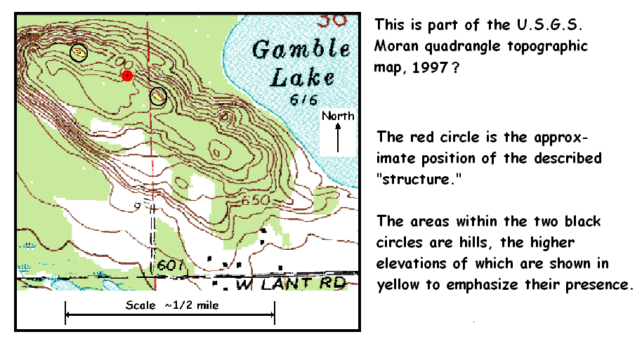
Location. Boat
Harbor is in the southeastern part of
Poupard Bay, in the NW¼ of sec. 5, T.40N. - R.4W.,
Moran Township, Mackinac
County, Michigan. Although
it is often not readily accessible by
road, the near-shore area is only ~0.25 mile southwest of the northern junction
of Gros Cap Road and Michigan Route 2 – i.e., approximately six
miles (as the crow flies) west-northwest of Saint Ignace. Per
Google
Earth, the central part of the area has the following
coordinates: 45o53'42.89"N. Latitude
and 84o50'25.68"W.
Longitude; its elevation is given
as 579 feet (177 meters) above MSL See Figure #1A-1.
Figure #1A-1.
Location of Boat Harbor. The left, regional map shows the
shoreline
from northwest of Epoufette (upper left) southeastward to the Straits
of
Mackinac -- i.e., to the northern end of “Big
Mac”
bridge (lower right of center). These two
maps depict only the general shape
of the current coastline, a shape that has changed and continues to be
modified,
sometimes rather markedly, with only small changes of the water level
of Lake
Michigan. During July of 2016, about 90
percent of the Boat Harbor rubble blanket was above the level of Lake
Michigan; breaking storm waves, however,
now and then
reduced that percentage, though seldom by any noteworthy amount. Contrariwise, during most of 2017, much of
the area was below the water level of both calm and rough conditions.
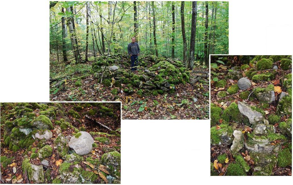
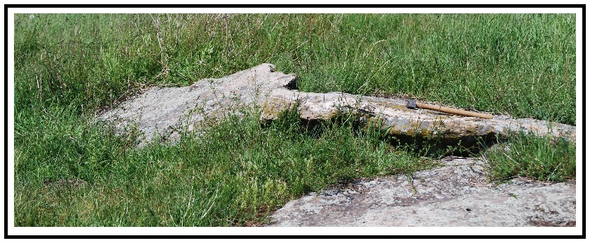
Description. A
typical part of the rubble, as it appeared in 2016 is
shown as Figure #1A-2a.


Figure
#1A-2b. Selected atypical
fragments from the rubble. Note in particular: The
diverse
shapes of the fragments of dolomite*1-1*/ – [Throughout this report,
the preceding indication – i.e., * X */ with a numberical
indication replacing the X – will
indicate the occurrence of a footnote; this one (1-1) is on the following page]. Notice especially 1.
the
fact that the
edges and larger surfaces of these fragments are less abraded than most
of the
fragments of the typical”
---------------------------------------------
Footnote
1-1. This
designation (i.e., dolomite), actually a mineral name, is used
throughout this
report rather than dolostone, a more appropriate rock name, because the
mineral
name has been, and continues to be, widely applied to sedimentary rocks
that
consist wholly, or largely, of the mineral dolomite. Although
some of the
dolomite loose rocks (i.e., stones) that constitute a large
percentage of
the fragments of the rubble blankets at Boat Harbor and nearby areas
contain
noteworthy calcite, all are referred to as dolomite in this tripartite
report.
---------------------------------------------
Although the dolomite fragments range from granule to boulder size,
most of
them are of pebble and small cobble size. In terms of roundness,
these fragments
range from angular to well-rounded, with a large percentage of
them
angular to subangular with all or most of their edges slightly rounded
and
their other surfaces abraded. Diverse
sphericities -- i.e., shapes – occur:
Some of them are roughly discoidal or
subprismatic; others are so irregularly shaped that they can
hardly be described
by words. Most of the fragments are light tan or
light
gray; the surfaces of some of them, however, include dark brown
spots
and/or a partial to complete coating; indeed,
parts of most
of the fragments that are beneath bordering or otherwise
overhanging
trees and bushes are stained, apparently as the result of changes
imposed by
solutions that “dripped”
from the overgrowth.


Differences
that led to the
out-of-place appearance of the holey
stones, as well as of the large
glyph-bearing stone, seemed at
first to depend upon lithological
differences
between the holey stones and the
so-to-speak typical fragments of the
rubble that blanketed the site. Later,
however, additional information and considerations relating to these
stones led
to a quite different explanation – i.e., these holey stones,
as well as the glyph-bearing stones,
were likely
brought to the area by humans. This
conclusion, granted tentative, is based on the
following information and considerations:
A.
No glyph-bearing stones like those found at Boat Harbor
are
known to have been found
elsewhere within the region -- see Report #1B.
Explanation
(Tentative
hypothesis)
The second tenet -- i.e., the
presence of these stones at the site supports the suggestion that the
site was
a trading post – needs to be established, or at least considered to be
a good
possibility. However, if that identity
is accepted as possible, the time or times that the site had such a
role remain
in question. Perhaps future research will
provide pertinent data. Currently, the
only apparently acceptable statement relating to the time frame is: The “trading post” was present
post-Pleistocene
and pre-local recorded or known history.
The number of times it was present is unknown. One
could, of course, make a case for multiple
times based on the differences of the two or three apparently different
characteristics and occurrences of the diverse glyph-bearing
specimens as well as the differences between all
those specimens and the holey stones.
I shall not.
Supporting
Data
The above tentative conclusion, which has both the glyph-bearing
and
holey stones brought into the Boat Harbor area by humans, is
based on
the following empirical evidence and considerations:
2. The presence of several holey stones –
i.e., those described in Report #3 – atop or within this rubble
deposit, whereas none, or only one or two, that even roughly resemble
these holey
stones were found to occur within any nearby rubble deposit *1-3*/.
---------------------------------------------
Footnote
1-3. Similar
nearby rubble “deposits”
were examined in July and August of 2016: Each of the
accumulations was either awash Lake Michigan or only a few feet from,
and
above, the then-existing shoreline. Those rubbles are located
sporadically along Lake Michigan between the marshland southeast of
Pointe aux
Chenes and “Sand Bay,”
which is near the northern end of Boulevard Drive, about one
half mile south of its junction with Pte. LaBarbe Road.
---------------------------------------------
3.
The general consensus that the patterns on the glyph-bearing
stones were incised by humans (see Report #1B).
4. The conjecture that the holey stones
must have
had some use (e.g., to produce something) or intrinsic characteristics
that
made them something to be possessed. Either
of those roles would provide at least subjective support for
the possibility that these holey stones
were brought to this harbor by humans. This aspect is treated further
in Report
#3, subsection
Why were these holey stones brought to Boat Harbor?.]
5. An additional
fact that seems to be of particular importance so far as the use of
Boat
Harbor in
the past, was brought to mind by a critical reader:
Boat Harbor was, until fairly recently (i.e., before dredging and building of relatively large docks here and there within the area), one of a few – perhaps the only – place between the Straits of Mackinac and Epoufette (See Fig. #1a-1) where near-shore water depths could serve watercrafts other than, for example, canoes. But, even though this is true, only a cursory examination of charts of today’s near shore line and topographic maps of this area and of Google Earth aerial photographic views of the area and adjoining region indicate the existence of several rather diverse former shorelines, some of which might have had other near shore, deeper water. So, if the tentatively suggested hypothesis has any applicability, it would appear to follow that this suggested “trading post” most likely existed at times when the shoreline was not greatly different from that of the current shoreline.
In any case, the topography of both the nearby land and offshore area require additional, more detailed analyses. This is so because such analyses might, among other things, set time limits so far as when, for example, a trading post could have been active at the site. In addition, such analyses might lead to currently unknown information about such things as the routes likely to have been followed and the likely characteristics of the water craft probably used within the Great Lakes region during certain periods of the Lake Michigan Episode – i.e., ~2200 years B.P. to the present. [see, e.g., Hough (1958) & Dietrich (1988).]
6. The preceding information
and inquiries
made about it led to my being told that the remains of a crib is on the
bottom
of the bay about fifty feet directly northwest of the area where the glyph-bearing and holey stones were
found. Son-in-law
Bob Brown found that they are six to eight feet (~two to three meters)
below the present water
level
of Lake Michigan, and also that a sub-lake ledge is just shoreward from
the
remains. These relations seem to indicate
that when used (apparently as part of a dock) Lake Michigan may have
been
several feet below any measured former lake levels;
if this premise is true, use of the dock would
seem to predate (local) historical times. [Next
summer I shall try to get more information about this structure --
perhaps some
dateable hardware or possibly part of the wood can be collected and
dated by
dendrochronology.]
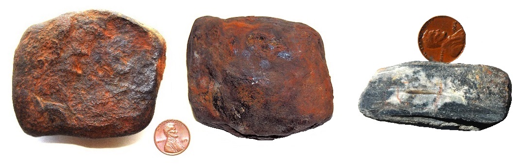
7. A
rust (limonite)-coated stone (see Fig.
#1a-5) was found in the same part of the Boat
Harbor rubble blanket as the glyph-bearing and holey stones. To
date, no explanation of its origin has
been found to be plausible; perhaps it
had something to do with metal working , . . .
[This
item, perhaps better an add-on, may have
no real place on this list. That said, it
is here, though it may relate
better to items 1 and 2.]
ACKNOWLEDGMENTS
for all three reports
Caroline
B. Cheeseman found the larger glyph-bearing stone.
Krista D(ietrich) Brown found the smaller glyph-bearing
stone
one of the times when she and
her husband, Robert B. Brown, took me to Boat Harbor; Krista also
helped
me collect holey stones while there. Kurt R. Dietrich
spent
several
days helping me navigate and searching
for additional glyph-bearing and holey stones in the
Boat Harbor
and nearby rubble-blanketed areas. Richard S. Dietrich helped me
navigate
the rubble deposit where figures #1a-3 and #1a-4 were
photographed. Reed
Wicander, Adjunct Professor, School of Earth and Environmental
Sciences, The
University of Queensland, Brisbane, Australia and Professor
emeritus,
Central Michigan University, identified the fossil shown in the
Addendum.
David D. Ginsburg, Research Librarian and Professor emeritus, Central
Michigan
University, formatted
the cited references.
Reed and David also furnished
literature not readily available to me at this remote location.
James J.
Brown, Jr., Krista D. Brown, Robert B. Brown, Robert T. Butka, Kurt R.
Dietrich, Richard S. Dietrich, John K. Evashevski, Lucy A. Evashevski,
Craig A.
Gibson, David D. Ginsburg, Daniel R. McGuire, and Reed Wicander
critically read
and/or discussed the content of one or more of the preliminary versions
of each
of the three parts of this tripartite report and/or a short version
that
included information included in these
reports.
I
gratefully
acknowledge their contributions.
References
cited
Dietrich,
R.V. 1988. The Geological History of Beaver
Island.
Journal of Beaver Island History, 3:59-77.
Hough, J. L. 1958. Geology of the Great Lakes. Urbana:
University
of Illinois Press. 313p.
Whitney,
G.D.
1997. Soil survey of Mackinac County, Michigan. Part 2. U.S. Department
of
Agriculture. National Resources Conservation Service
(accessed 22 January 2017)
Report
#1B.
The
glyph-bearing
stones from Boat Harbor, Gros Cap,
Michigan
Identity
of these stones
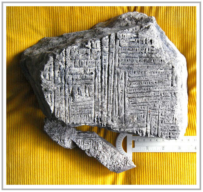
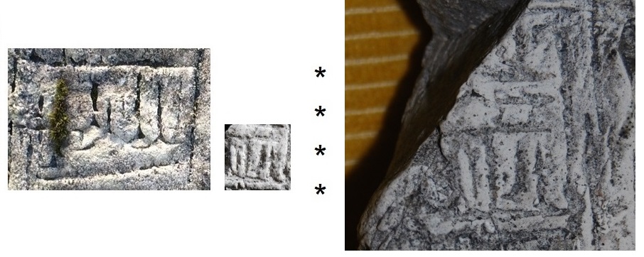
The glyph-bearing
stones are dolomite. To date, the formations from which
they came
has not been established. The two of these stones, which are
shown
in
Figures #1b -1a & 1b, were found in 2016, The
larger one was atop the rubble blanket at
Boat Harbor, the smaller one partly in, but mostly out of, the rubble.

In
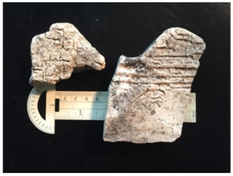
September 2017, two additional glyph-bearing stones
were found as fragments within the rubble that was continuous with rubble blanket but
a few feet farther from the shore at Boat Harbor. These
glyph-bearing
stones (See Fig. #1B-2) are the
specimens referred to as anomalies in Report #1 (page 10, line 9). That designation relates to the fact that
both their characteristics and their occurrences differ from those of
the first
found glyph-bearing specimens: They are smaller (see
Fig.2-2); their shapes are similar to the
shapes of the
“typical” rubble fragments; the
characteristics of their incised patterns, especially of the larger
one, differ
from those of the glyph-bearing specimens
found in 2016; [and] these
2017
specimens occurred as integral parts of the rubble. One
wonders if these specimens may have been
so-to-speak “throwaways” or perhaps fragments that were broken off
larger
fragments, discarded, and subsequently easily
incorporated into the rubble proper. Many
alternatives, some involving time and
originators of the inscriptions, can be made;
until more information about the incised forms becomes known,
none of
the alternatives seems worth recording.
[Note:
Although neither of the following bits of information seems
directly
related to the glyph-bearing stones treated
in this report, both occurrences seem noteworthy here:
1. On May 4,
2017, a newspaper
report dated May 7, 1892 was republished (Anon., 2017) that records the discovery of
a “flat and diamond
shaped [stone ...;] on one side are hieroglyphics, which present the
appearance
of having been made by human hands”
during
digging of a ditch near the St. Ignace Court house.
To date, I have found no additional information
about this stone.
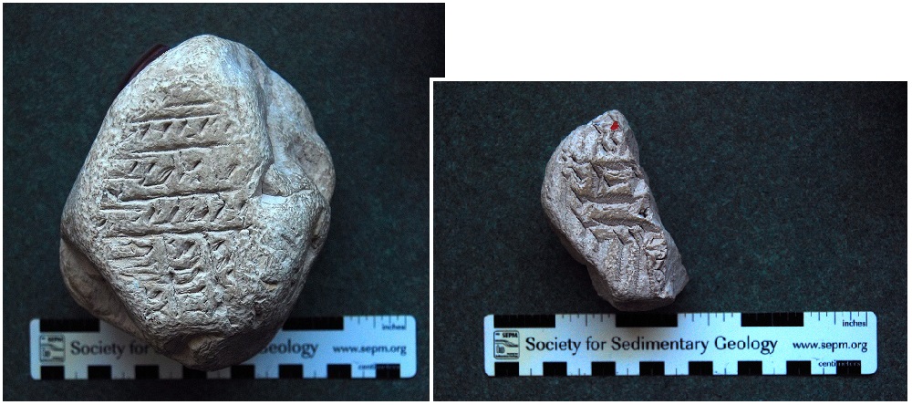
2. In
mid-August, 2016, I
was told that a stone with “hieroglyphics” on
it had been found by Brevort Lake resident Robert Frazer in rubble at a
quarry
that is about one mile east of, and 170 feet (52 meters) higher than
Boat
Harbor. Frazer actually had two specimens (see Fig. #1B-3). As can be seen, the inscriptions on each of
these
stones differ markedly from those on the Boat Harbor specimens. It seems that any
bearing these stones have on the
tentatively suggested hypothesis (Report #1), is moot.
Who
incised the patterns?
The
fact that the
“incised” *2-1*/ surfaces
of the Boat Harbor specimens have undergone
weathering and erosion makes definitive statements about their original
characteristics speculative. In addition, no fragments
of “tools” –
e.g.,
----------------------------------------
Footnote
2-1.
“incised”
is used in this report to indicate
mode of formation of the
following
patterns that characterize the glyph-bearing” surfaces
of these rocks. It should not be
considered to indicate any particular mode of formation –
e.g., the use of tools versus etching.
----------------------------------------
An expert glyphologist might be able to say several
definitive
things about these surfaces –
e.g., who may have made them, when they were made, and their
intent/function(s). -- [To date, no contacted glyphologist
has opted
to look at these specimens.]

Figure
#1B-4a.
Features within the circles and ovals appear NOT to
resemble forms known to be natural. (photo by Caroline Cheeseman)
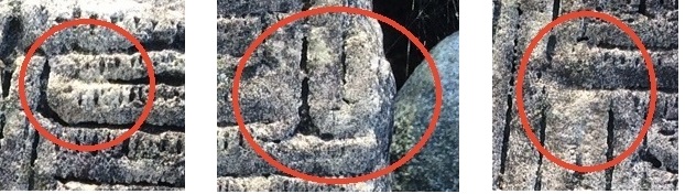
Figure
#1B-4d.
A roughly similar
pattern that is on both specimens:
Left, part
of the larger specimen; center,
part of the smaller specimen. These two
are
shown at the same scale in these photographs.
Right,
enlargement of the center photo and its surrounding area.
-- This is included to facilitate comparison
of, for example, the lower ends of the “characters” and the surrounding
rectilinear “frames” of the smaller specimen with those of the larger glyph-bearing
specimen, as shown on the left.
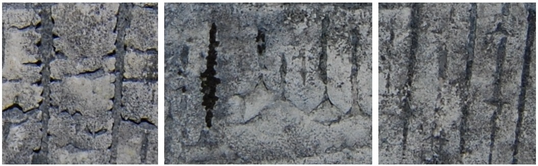
Internet searches were made (in 2016) using images and keywords, both individually and in combination, to see if any similarly appearing surfaces were recorded on-line. The following were among the “hits” made during the searches, followed by a clause that relates to overall differences or similarities between their patterns and those on the Boat Harbor glyph-bearing stones: Early Sumerian Cuneiform (dated 8,000-3,000 BCE) – some of these patterns (including both
---------------------------------------------
Footnotes
2-2. A.
Images of the preceding “glyphs”
are available on-line. No particular reference, other than the
one given,
seems to warrant citation here.
B. Comments
in this paragraph do not refer to the specimens shown in Figure #1B-3.
---------------------------------------------
What
was the function of the glyph-bearing stones found at Boat
Harbor?
To
date, no function for
these stones that seems noteworthy has come to mind or been suggested
by anyone
who has seen these specimens or photographs of them.
More than a year after the preceding paragraph was written,
David Ginsburg
(personal communication, email – dated 28 August 2017), a
critical reader of an earlier manuscript of
this report, directed my attention to an article by Albaz et al. (2017)
and
suggested that the Bar Harbor glyph-bearing stones might
have been
part of a board game. This led to reminisces of my small home
town which
included not only
a general store but also a "pool hall", which were activity hubs of
that
town,
and led me to the following question: If the holey
stones
described in Report #3 were marketed, could these glyph-bearing
stones
have been used as game boards or for keeping scores in a neighboring
“game
parlor” at the hypothesized trading post?
(Certainly both such enterprises might well be located at such a
place!). Further considerations, however, have led me to think
that the
original patterns on these glyph-bearing stones seem likely to
have been
too intricate for such use. Consequently, although it seems
prudent to
mention this possibility, it also is something that I have neither the
knowledge nor background to pursue further.
Two, so-to-speak, interrelated, questions appear to pertain:
Does each line, ‘character’ or section of the pattern on the larger glyph-bearing
stone have a meaning? OR Alternatively,
does the whole surface of
the specimen constitute an image that depicts some entity?
The
immediate answer to the each line or ‘character’ possibility
seems to be NO!, at least not one that can be
translated. This opinion is based largely on characteristics
of the
lines (See Figs. #1B-4b & 4c) and the presence of so much apparent
repetition. [Granted, the original, incised surface may have
exhibited
characteristics, now weathered and eroded away, that would have
indicated
otherwise. Also, one must admit that even using only the
currently
available surface, any imaginative story teller (I think of my
Grandfather
Vincent and his reputation along this line) might very well come up
with one or
more interesting “translations.”]

References
Cited
Albz,
Shira, Shai,
Itzhaq, Haskel, J.G., and Maeir, A.M.
2017. Board
games in biblical Gath. Biblical Archaeology Review 43(5):22,
68.
Anon.
2017. Looking Back [125 years ago], The
St. Ignace
News, Saturday, May 7, 1892] The St. Ignace News, May 4,
2017., p. 20.
Dietrich,
R.V.
2017. Do You See What I See? – Rocks, minerals, wood, clouds
and a
peach pit. Ripon,WI:the author. 120p.
Miragaya,
Karel.
2015. Ancient Sumerian cuneiform writing engraved in a
stone. 123RF.
<http://www.123rf.com/photo_3302013_stock-photo.html>.
(accessed 29 December
2015).
Report
#1C. The holey
stones from
Boat Harbor, Gros Cap, Michigan
Notes:
The
main part of this report is about the holey stones
that were found atop, or in part within the rubble-blanket at Boat
Harbor and
how this occurrence is thought to relate to the tentatively suggested
hypothesis given in Report #1A –
i.e., the
possibility that an onshore area south of Boat Harbor may have been a
trading
post one or more times in the so-to-speak ancient past.
While preparing this report, certain aspects
of holey stones as a group seemed
also to warrant consideration: The
Appendix to this Report (#3) includes two of them – i.e., a brief,
probably applicable geological history that relates to the holey stones
and conclusions related to
the origin of
the Boat Harbor stones. Two others -- 1.
A list of previously recorded synonyms of holey stone.
and 2. A brief review and evaluation of or comments about
suggestions previously recorded for the formation of holey stones
that
are at least roughly similar to those collected at Boat Harbor – which
seem not
worth publication; a copy of these can
be sent to anyone who requests them.
Definition
The designation of holey stone, as used in this
document,
is strictly descriptive – i.e., no origin of these stones (other than
their
being of natural occurrence) is included or implied.

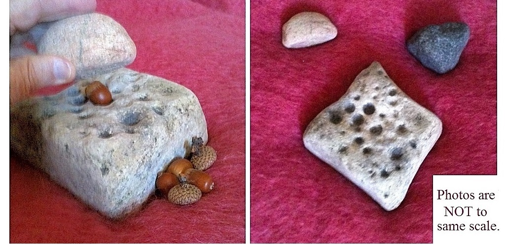
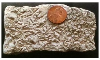
Figure #1C-1. Four differently
shaped holey
stone cobbles from Boat Harbor: The scale is a 12
inch
ruler; the third dimension (i.e.,
perpendicular to the main surfaces, as shown) for these stones is ~2
inches (~5 cm). A.
irregular shape,
well-rounded edges; B.
sub-prismoidal, rounded edges; C.
ovoidal shape; D.
roughly discoidal
shape, rounded edges. [These stones have been washed and brushed
with
plastic bristles.]
Figure
#1C-2. The two sides of specimen D
Figure
#3-1. This specimen
could have been easily spotted and collected for this study regardless
of which
one of these two surfaces was exposed.
Why,
how, and when did
these holey stones get to Boat Harbor?
These questions arose as a consequence of the
conclusion, albeit
speculative, that these stones did NOT get to Boat Harbor as the result
of
natural transport.
Why?
This
question, stated otherwise is: What activity or activities may
account
for the presence of the more
than a score of holey stones at Boat Harbor?
–
Two
possible answers seem obvious: 1. These stones
were dumped there. OR
2.
They were brought to the site for
some particular on-site use and/or because they had some intrinsic
value and were
brought here to market to those who stopped at the harbor.
As noted in Report #1a, the possibility that the holey stones
were dumped at the site
seems
highly unlikely. Therefore, the just
alluded-to alternatives –
i.e., these
stones were brought there to use and/or to market –
warrant special consideration.
So
far as possibile
use of the stones on the site: For
untold ages, humans and other primates as well as several other
animals,
including birds, have used stones – e.g., as hammerstones and as the
anvils
upon which nuts (etc.) were placed to facilitate their cracking. [For
early
literature relating to this use see Ritchie
(1929), and, so far as the
Boat Harbor holey stones, see also Gray & Pape
(2016).]
Indeed, holey stones similar to those found at Boat Harbor are
said to
have been used widely by Amerindians –
e.g., the Ojibways and Hurons of this general region – to remove the
shells of
acorns, which they harvested and used as a staple of their diets (see
Figure
#1C-3); they ate the “meat” of the acorns and extracted the
acorns’
oils, which they used in, for example, cooking [see, for example,
Kuhnlein & Turner (1991, after Waug (1916, p.122-123)].
The
marketing possibility appears to
fit the data better. Among other things,
it
seems
more likely that the Boat Harbor holey
stones would have been abandoned by only one or so marketers than
by a
couple dozen or so workers, who would have apparently had to have
abandoned
their tools (i.e., their anvils, which would have been part of their
very
livelihood) virtually simultaneously – Granted, such a larger group
could have
been raided, ... or perhaps even shanghaied, . . .
How?
If
either or both of the just mentioned possibilities
obtained, the answer to this question is: These holey stones
were
brought to Boat Harbor by Humans. – Indeed, it is this previously
stated conclusion,
which seems best to explain the presence of these holey stones, as well as of the first two found
glyph-bearing stones at Boat Harbor, that led to the
introduction of
the tentative hypothesis given in Report #1 – i.e., the Boat
Harbor site was
a trading post one or more times during the past.
When?
No
information has been found to indicate the time or times
when the tentatively suggested “trading post” may have
existed. It
seems safe only to say that it was post-Pleistocene glaciation, and
pre-recorded and currently found oral local history. The
post-Pleistocene
limit is based on the presence of glacially transported stones within
the
rubble; [. . . *3-8*/];
[. . . *3-9*/]; the
pre-recorded
history limit speaks for itself.
------------------------------------------
Footnotes
3-8.
Perhaps information about the holey stones found in
Adams County, Ohio,
which closely resemble those
found at Bar Harbor, bears on this question.
Those
3-9.
As
previously noted (Report #1, page 9),
the remains of a crib, the top of which is 6 to 8 feet (2 to 3
meters)below the
present water
level of
Lake Michigan, is about 50 feet (~15 meters) directly northwest of the
area where the glyph-bearing and holey
stones were found. The following
additional information about
that former structure seems to support the pre-recorded (local) history
date: A nonagenarian has indicated that
he frequently went swimming within the area as a youngster and does not
recall
even hearing about either the use or presence of any dock of which the
crib
remains would have been a part. So, it
seems
quite possible that this former dock, if it was such, may have been
used well
before local historical times.
REFERENCES
CITED
Gray
& Pape.
2016. How Do You Crack a Nut?. < http://graypape.com/how-do-you-crack-a-nut/ >
(accessed 31 January 2015).
Kuhnlein,
H.V. and N.J.
Turner. 1991. Oaks. Traditional plant foods of Canadian
indigenous
peoples: Nutrition, botany and use. Food and nutrition in History
and
Anthropology. Amsterdam:Gordon and Breach (Vol.
8, pp. 199-201).
<https://books.google.com/books?id=fPDErXqH8YYC&pg=PA199>(accessed
1 January 2016).
Ritchie,
W.A.
1929. Hammerstones, anvils and certain bitted stones.
Researches
and transactions of the New York State Archeological Association.
VII(No.2):29p.
Waugh,
F. W. 1916. Iroquis
[sic] foods and food preparation. Canada Geological survey
Memoir 86,
Anthropological series no.12. Ottawa : Government Printing
Bureau.
266p. < http://www.archive.org/stream/cu31924101546921/cu31924101546921_djvu.txt
> (accessed
4 December 2016).
Appendix.
Geological
history relating to the Boat Harbor holey stones.
Readily
available evidence, some of
which is speculative, appears to support the following geological
history for the Boat Harbor holey stones:
Deposition of
parent *3-1*/ sediment
in a northern part of the marine Michigan Basin – probably
Late Silurian (~460-415 MYA *3-2*/).
Lithification –
including dolomitization (diagenetic?) of those sediments – (pre ~390 MYA).
Collapse of the above and associated rocks
into
subsurface “voids” to
form the
Mackinac Breccia – pre-Early
Devonian (Dundee) (~380 MYA) -- [Dissolution of
Silurian
Salina salt appears to have created the voids.]
Exposure of
the “parent” rocks,
including
those within the Mackinac Breccia, to weathering and erosion, with
separation
of masses of the “parent” rocks
from
outcrops and incorporation of the loosened fragments into moving
water – (~300 MYA).
Boring of the holes in the loose rocks
that are
now holey stones –
(~? ? ? MYA *3-3*/ ).
Abrasion of the hole-bearing
fragments – (~? ? ? MYA *3-3*/ to present).
---------------------------------------------
Footnotes
3-1. Parent – this
term,
used as an adjective, refers to the sediment, the resulting lithified
rock that
became the holey-stones that are
treated in this report, and the extended use – e.g., parent rocks – for
the
Lower Paleozoic associated formations.
3-2. MYA
–
Million years ago.
---------------------------------------------
The
above possible
history notwithstanding, to date, the time(s) when the holes were bored
into
their host rocks, now loose stones, has not been established. It is
only known
that during this study no fragments of these rocks that contain
such
holes were found within the Mackinac Breccia*3-4*/
or in nearby exposures of the parent formations.
These apparent absences, at least permissively, support the conclusion
that the
holes were bored after the fragments were freed from outcrops of their
“parent”
formation and/or from rubble fragments of those parent rocks that were
within
the Mackinac Breccia. This likelihood is supported by the fact
that most
of these holey stones have holes on both their top and bottom
surfaces.
----------------------------------------
Footnote 3-4. Localities
where constituents of the Mackinac Breccia were
examined, as given on Google Earth, follow: St.
Anthony’s
Stack near downtown St. Ignace (45º 53’ 04.59”N. –
83º43’34.90” W.);
unnamed masses on the western side of North State Street (Rte. B75),
St. Ignace
(45º53’05.64”N.–84º43’33.12”W.); and Gros Cap
Rock, two localities
northwest of St. Ignace –
Rest Stop on Rte. 2 (45º 53’ 02.16”N. –
84º50’08.69”W.) and along the eastern side of Gros Cap Road
(~ 45º 53’ 01.65”N. –
84º50’13.06”W.).
----------------------------------------
How
were the holes of these holey stones formed?
To
date, the origin(s) of the
holes of the holey stones found at Boat Harbor has(have) not
been
proved. The possibility that they were formed by some boring
creature –
e.g., a boring clam – and subsequently modified by weathering and
abrasion
seems best to fit the facts. Two
alternatives
that seem also to warrant further consideration are:
1. Borings by other invertebrates and 2.
Differential weathering of, for example, a
halite (salt) bearing dolomite.
1.
Other
Mollusca (e.g., moon snails), and certain
arthropods, sponges, sea urchins, and
worms, are known to have bored holes in sediments and/or rocks
[see Frey
(1975), Miller (2007), and Seilacher (2007)]. In addition, Weaver
(2015),
for example, has reported that “Some snails – particularly moon
snails –
soften a clam’s shell by using a boring organ
that produces hydrochloric
acid,
enzymes and other
substances; [and] subsequently, the
snail rasps the softened clam shell with a hard plate called a radula,
and a
circular hole” is formed. Could they
also have done this to calcareous rocks (e.g., this dolomite)?
2.
Differential
weathering and/or erosion is widely accepted as the process responsible
for the
production of surfaces such as those shown in Figure #1CAp-1: the configurations on this and similar
surfaces of this formation are thought to have
resulted from dissolution of masses (e.g., of gypsum) that
were crystallized from solutions and deposited along with the enclosing
calcareous
sediment; the surface shown, like many of them now found , also
exhibit subsequent weathering and erosion. This
mode of formation and subsequent history has also been suggested to
have been been the originiation of holey-rocks that
are similar to those found at Boat Harbor (Ehlers
and Kesling, 1957,
p. 5-6); by implication the
probable dissolved mineral matter was apparently thought to have been
either
halite
crystals or globules. This possible
origin is considered unlikely, though not absolutely precluded, as the
mode of
formation of the holey stones found
at Boat Harbor, among other things,fresh
cross-sections
were made of two holey stone
specimens, and neither was found to include any enclosed
masses of
halite or any other mineral that would have led to this mode of
formation.
Figure
#1Cap-1. Late Silurian-age Saint Ignace Dolomite (Bass Islands
Group). It is widely accepted that these surface features were
formed as
the result of dissolution of crystals of, for example, gypsum that
were
included within the original sediment.
---------------------------------------------------
Footnote
3-5.
One
feature, in particular, of these holey stones appears not
only to
support this conclusion, but also to indicate that the parent fragments
were
then in moving water: Nearly all of the holes in
these stones
are on both sides of the stone’s two larger surfaces – i.e.,
their
probable tops or bottoms whenever they were at rest, during any
transport or,
for example, now and then moved by breaking waves. This fact, if considered along with the widely
accepted, above outlined, geological history of the
region, indicates that
the holes were likely formed when the fragments were in a non-marine
environment. In addition, it seems to follow, that at least
some of
the abrasion of these stones also occurred during the same general
period
although it seems that at least some of the abrasion has taken place
more
recently; indeed, it is occurring at least intermittently even now!
----------------------------------------------------
It seems only prudent to direct attention to the
fact that
the above tentative conclusion about the origin of the holes of the holey
stones found at Boat Harbor leads to an apparently troubling enigma:
According to malacologists and paleontologists whom I have contacted,
boring
clams are not known in freshwater environments or as fossils within
sedimentary
rocks that are known to have a freshwater precursor sediment. This, despite
the fact that the caption for a sketch in
Moore, Lalicker & Fischer (1952, Fig.10-2) includes the
following: “Burrowing
types of pelecypods. A majority of this group of clams burrows in
the soft
mud, silt, or sand beneath shallow seas or on the floor of
fresh-water bodies.” And, the
sketch includes a burrowing clam, “Pholas,” in rock. *3-6*/.
----------------------------------------
Footnote 3-6. The
following facts and comments pertain:
Boring clams have been recorded as existing in rocks from marine environments since
Ordovician time (Miller, 2007, p.363).
“Interesting that no references I’m aware of since 1952 mention
freshwater
boring clams. I would think someone would have. Perhaps
Moore et
al. was just making a general statement? [and] I don’t think you
can use the sketch as evidence of a freshwater environment.
I think
it was just a general sketch.”
(Wicander, personal communication, 23 January 2017)
----------------------------------------
Notes: As
a “hard rock” petrologist,
I
leave the above, apparent lack of agreements, etc.to professional
malacologists, paleontologists et al. to resolve.
The fact that a very
high percentage of the literature about, for example, Paleozoic strata,
is
based on marine environments, might account for the lack of
information
about non-marine hole-boring invertebrates, if such ever did
exist.
Tangential research
that might have led to information related to post-hole-formation
environments
that these rocks were in can be summarized:
More than 500 holes in the holey stones
from Boat Harbor were examined under magnification.
Nothing
noteworthy was found in any of them. Two
other stones from the site, both of which have holes in them, were
subsequently
collected, similarly examined, and found to have something in one or
more of
their holes: One of those stones, a
rather typical rubble fragment, both size- and shape-wise, has several
relatively small holes, some of which are coated as shown and described
on
Figure #3-4, A, The other, a holey
stone, which is petrographically like the typical holey stones
of
the site but it is shaped more like rounded stream cobbles, has two of
several
typical holes, one of which includes the features shown on
Figure #3-4, B). To date, the
identities of these included
materials have not been determined; I do
not have the availability of the required laboratory setup. More later, I hope!
Figure
#1Cap-4. A. The width of the top
of this hole is
~5/8th inch (~1.6 cm.). The
vertical arrow points to the area shown in the closeup;
the small inset at the top is for those who
see the larger photograph as a dome rather than a hole.
Similar growths are elsewhere on the
fragment, both in a few nearby holes and sporadically on other surfaces.
B. The hole in which the
objects shown occur has
a diameter of ~13/16 th inch (~ 2 cm) and a depth of ~3/4th inch
(~ 1.8 cm). The longest dimension of the
“growth,” that
consists of two parts, each of which roughly resembles a barnacle, is
approximately 3/16 th of an inch (~4 mm).
Neither of these
materials was
identifiable by a professional biologist or a professional
paleontologist who
examined the specimens and the photographs, respectively.
REFERENCES
CITED
Ehlers,
G.M. and R.V.
Kesling. 1957.
Silurian Rocks of Michigan and their
Correlation.
<https://deepblue.lib.umich.edu/bitstream/handle/2027.42/48577/ID435.pdf
> {accessed 5 September 2017) 20p.
Frey,
R.W. (editor). 1975. The study of trace fossils: A synthesis
of
principles, problems, and procedures in ichnology. New York:Springer-Verlag.
Landes,
K. K., Ehlers,
G.M. and G.M. Stanley. 1945. Geology of the Mackinac Straits
Region
and Sub Surface Geology of the Northern Southern Peninsula. Michigan
Geological Survey, Publication 44: Geological Series 37. <http://www.michigan.gov/documents/deq/GIMDL-PU44A_302655_7.pdf >
and <http://www.michigan.gov/documents/deq/GIMDL-
PU44B_302676_7.pdf>
(both accessed
7 February 2016).
Moore,
R.C., Lalicker, C.G. and A.G. Fischer. 1952. Invertebrate
Fossils. McGraw-Hill:New York.
Rosenau,
J.C.
1956. Mackinac Bridge: Final Geologic Report. < http://www.michigan.gov/documents/deq/Final_Geological_Report_306059_7.pdf
> (accessed 4 January 2015
Seilacher,
Adolf. 2007. Trace
fossil analysis. Berlin:Springer-Verlag. 226p.
Weaver,
Trish. 2015 (July 9). The hole
truth about animals that bore. N[orth]C[arolina] Museum of
Natural
Sciences Research Blog.
< https://naturalsciencesresearch.wordpress.com/2015/07/09/the-hole-truth-about-animals-that-bore/ >
(accessed 17 August
2016).
 \
\

“Though
they [i.e.,
pop-ups] form only a minor structural and topographic feature, they are
rather unusual
and the interest
attaching to them is out of all proportions to their size and
frequency.”
(H.P.
Cushing , 1910)
A
pop-up, previously mentioned in an obscure publication (Dietrich, 2008,
p.61) and apparent modifications of a nearby pop-up, first recorded
more than a century ago (Cushing et al, 1910, p.115) are described in
detail. Questions and comments, which arose as these descriptions
were
recorded, are also included.
Diverse names
have been given these and similar features. Examples, not
necessarily the first uses, are: A-tent (.....), blister (Kielosto & Aimo Kejonen, 2011), expansion dome (Lowry, 1959),geological wrinkle (Gilbert, 1887), popup (Jacobi, 2007),
... None
of these is included in the AGI Glossary (Bates & Jackson,
1987). Pop-up, as used herein has no genetic implication.
It's choice dates back to what I heard the Cushing structure called
before I read the first report about any of these structures.
Find reference and add it, and try to fine additional terms
listed in the references
cited?!!
PETROGRAPHY. The Potsdam Sandstone within the area is described by
Buddington (1934,
p.179) and Dietrich (1957, p.101). The strata involved are
silica-cemented, medium- to coarse-grained, well-rounded quartz sand, a few lamellae
of which consist largely of hematite-coated grains. Depending
upon what
nomenclature scheme is used, these rocks can be called either sandstone
or
orthoquartzite.
STRATIGRAPHIC POSITION. General stratigraphic relations and information about the
variable thicknesses of this Cambro-Ordovician formation within the
area are described by Cushing (1916, p.32 et seq.).
DATE OF FORMATION. The fact that the two pop-ups were formed since the last
glaciation of the area is indicated by the presence of glacial striae
and chatter marks on the upper surfaces and their absence on the other
surfaces of the blocks of these structures. None of the the
"blanket"
names, such as Wisconsinan, are used for the glaciation involved in
this note because the assumptions
upon which they were based have subsequently been concluded to lack
their originally assigned application.
BETTER
PHOTO(s) to come!!!!
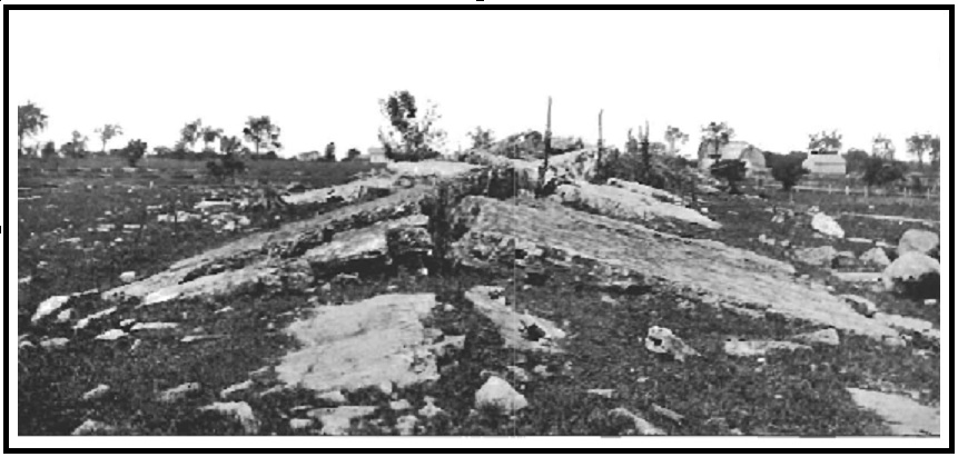
This pop-up (see
Fig. 5 #1) is located a few yards west of Route 37, ~1.8 miles
north of Hammond village. It
consists of two,
continuous sections, each of which has a virtually straight axis; the
strikes of these axes differ by ~!0 degrees. Dimensions (with
metric equvalents listed in Appendix) and descriptions follow:
Location: across Route 7 from
the junction of Hadlock Road (i.e.,
at ~
44°28'22"N; 75°40'58"W; elevation
~341ft.MSL).
Strike
of axes: Southern
part – N35E;
Northern part – N25E
Height
of apex above level of surrounding surface: up to ~3 ft.
Southern part – ~X ft.
Northern part – ~X ft.
Width
of structure: ~15
ft.
[[ <chk are
both parts of same width? AND THIS
needs more measurements and explanation. ]]
Sizes of blocks:
Southern
part – ~ 2½ x 5½ x ¾ ft. = ~ 10¼ feet3 weight?
(delete
this one? -- One of smaller ones: yy x yy x yy)
Northern
part -- Largest: ~ 7½ x 14½ x 2/3 ft. = ~
72.5 feet3 weight? .
(delete
this one?? -- One of smaller ones: yy x yy x yy
1. (if
none, say so)>. Glacial striae and
chatter (i.e., percussion) marks are on the original, nearly horizontal
tops of blocks but NOT on their other surfaces.
2. The broken surfaces
of the blocks that are at a high angle to the axis of each of the two
segments of thIs pop-up are approximately vertical.
3.
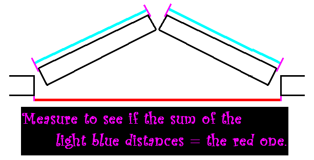
The block on one side of the axis of each segment overlaps its opposing
block, AND, with exceptions, each overlapping block is adjacent
to a
block that is overlapped by the block on the opposite side of the
axis (Cf.
Cushing et
al.,1910, p.116, Fig.10 --
given as Fig.5-#2 in this report ). <<
D:– perhaps refer to it as a Mortise
and Tennon arrangement?
4. Record
details re junction of the two segments and describe here. Get
photos IF POSSIBLE!
5. ( IF exposed, MEASURE STRIKEs
and DIPs OF NEARBY JOINTS!!; IF not, perhaps(??)
cite diagram in Brier Hill report. )
This pop-up (see
Fig. 5 #2)
is about 3.9 miles south-southwest of Hammond village
– i.e., about 1.8 miles south of Chippewa Bay.
Location: southwest
of Webster Road, ca. 0.15 mi. from its junction with Callaboga Road (i.e.,
at ~
44°24'51"N; 75°45'25"W; elevation
~361ft.MSL).
Strike of apex: N.72E [per Cushing: N.28W] RECHECK!!!
Height
of central part of apex above surrounding surface: ~ 6 ft. [per Cushing: about
12 ft.]
Length
of structure: ~ 45 yds.
Width
of structure (i.e., between edges of blocks on opposing sides): ~ 14 yds (i.e., ~ 42
ft.)
THIS needs more
measurements and geometric explanation.
DELETE FOLLOWING?? One of smaller ones. ~3.5ft. x 3.5ft. x
0.5ft.
1. Glacial striae and
sporadic chatter marks are on the original tops of blocks but NOT on
their other surfaces.
2. The broken surfaces of the blocks that are approximately
90º
to the axis of this pop-up are nearly vertical but they range from relatively
smooth to highly irregular --
see Fig. 5-#X. (what
about space between blocks on same side?? do they match -- i.e., except
for post-fm erosion?? -- how much erosion?? OR were they
separated in that direction when the structure was formed?? --
i.e.,
was there "stretching parallel to axis??)
3.a. The broken surfaces of the tops
of the blocks that
are approximately parallel to the axis are
....describe
completely/at least roughtly.... (can
they be matched like jig-saw puzzles ????)
b. The broken surfaces of the
bottoms of the blocks that
also are approximately parallel to the axis of this structure are
.......(can
they even be seen??? if so, can they be matched like jig-saw
puzzles ????)
4.
Only a few of the broken surfaces that so-to-speak define the axis of
the structure overlap as indicated by Cushing (Cushing et al.,.1910 -
p.116, Fig.10) -- instead, nearly all of the blocks
that are on the northwestern side of the apex overlap the blocks on the
southeastern side -- (see Fig. 5-#X Calaboga 8&9). However, considering
the fact that Cushing's indicated height of the apex is significantly
greater than it is now (2016), the following question and comments seem
noteworthy, and possibly
explain this discrepancy in Cushing’s recorded observations and those
made during this study. Have
the blocks moved outward from the axis --
i.e., undergone post-formation partial collapse? since Cushing mapped the
structure in the early 1900s (See if their bottoms are atop the
surrounding, nearly horizontal ss OR are they still so-to-speak "stuck
in place" (i.e., have their ends adjaent to the top edge of the surface
from which they broke off (<< --Wow -- what a
description!!!) -- Along this line, one or more of the following
activities may have occurred and, if so, would support
an affirmative response: a. Trees have grown in the
axial since Cushing's observations -- (see Fig. 5-#XCalboga
9). (Tree wedging – e.g., see Dietrich (1957, p.21, Plate 6) --
provides permissive support so far as their having a causative role for
such movements of the blocks.) b. The surrounding, nearly
flat bedrock is exposed on the southeastern side of the structure
whereas the other side is covered by soil; and slipping
atop the exposed rock, possibly enhanced by seasonal ice build up on
the surface of the flat-lying, surrounding sandstone would
likely be away from the apex, mainly to the southeast. AND, such
movements would result in the apparent change in height and possibly
also account for the apparent differences in the character of the
overlapping relationships along the crest of the structure.
5. (Measure/record
Strikes & Dips of nearby
Joints! )
ORIGINS
The two pop-ups may have similar or different origins;
this may be true so far as both the pre-formation controlling
conditions of the rocks and/or the causative triggers (see COMMENTS …). No origin has been
or is herein suggested for the Hadlock pop-up. Several comments
about the possible origin of the Cushing pop-up are in the literature
(e.g., Cushing in Cushing et al, 1910; Twidale
and Bourne, 2005; and Jacobi
et al., 2007).
Two considerations indicate that only a comment about the an
origin should be given in this note. This is so because: 1. No data (i.e., values)
relating directly to the stress -- internal/residual/compressive -- of
the sandstone of either of these structures or the surrounding rocks
are available. 2. Two
seemingly significant references-- i.e. Dames and Moore, 1974 and
Smith, 1977 -- that pertain directly to the Cushing and other nearby
pop-ups have been unavailable, even via ILL. 3. The required
considerations for making such conclusions should not be made by one
with my background. -- The comment is:
I think that changes
of conditions -- e.g., those that accompanied deglaciation and/or
post-last glaciation isostatic rebound -- had major roles in
both the build up of internal stresses and their release, which led to
the formation of at least some pop-ups; and, the release of the
stresses seems likely to have been abetted by “triggers.”
((That
comment is based
largely on impressions gained from: a. data recorded in this
note; b. a review of the available literature relating to pop-ups
and the pertinent tectonic domain of the region; [and] c.
considerations relating to Lowry’s (1959) and my (1961) investigations
of the Mt. Airy “granite” and the subsequently determined residual
tress information, which was obtained by U.S. Bureau personnel who
utilized sed overcoring procedures of in situ rock at the North
Carolina quarry. Their results were concluded to indicate that
the conditions were “ripe” for the continual formation of additional
buckles at the quarry.
((To elaborate further, the following thoughts have arisen in my mind several times since I again saw the Cushing pop-up and had my attention directed to the Hadlock pop-up:
((The axes of these pop-ups have different strikes; in fact, the Hadlock structure has a bifurcated, albeit continuous, axis -- i.e., the strike of axis of one of its sections, differs from the strike of the axis of the other section. In addition, none of these strikes appears to fit any obvious pattern or to correlate with the current, granted, less than well-established, regional tectonic/stress pattern.
((The structures appear to have been formed after the last glaciation -- i.e., after the load of glacial ice, plus its debris, was removed -- and during the subsequent, still on-going, isostatic rebound.
((The so-called “trigger” could have been instantaneous or a slow (i.e., a gradual change in the position and condition of the rock until a critical condition was exceeded). Two examples of the latter might be the removal of the glacial ice and its load (and/)or the subsequent isostatic rebound – i.e., when a release of the compressive stresses within the rock exceeded a value whereby formation of one or more pop-ups was inevitable.
[[ ((---No stress
measurements for rocks of either pop-up or nearby equivalent strata are
known, and cannot, in any case, be determined exactly for the time the
Hammond
area pop-ups were formed. It can, at best, be hypothesized that
the horizontal stress(es) exceeded the vertical -- i.e., upward --
stress. If, however, current measurements of the internal
stresses of the rocks of these structures and of similar near-surface
Potsdam sandstone in the area were made, possibly those data could be
programmed to create a model that might indicate -- i.e.,
so-to-speak replicate -- the approximate previous conditions, and
perhaps even how these pop-ups may have been formed be it
initiated by a
"slow trigger" or by a trigger per se. -- See paragraph XX in
the following Comments and Questions section.)) ]]
DElete the
following??!! As I typed the above comment
plus, two old “saws” came to mind: “Fools rush in where
wise men fear to tread.” and “There’s
no fool like an old fool” (I am 92 years old).
It seems prudent to preface the paragraphs of this section
with a disclaimer: Because
of my lack of access to some of the publications I believe I should
review, readers are urged to insert So
far as I know before
each of the following paragraphs.
The
first five of the following paragraphs relate to the possibility
that burial beneath
thick glacial ice had a role in the formation of these pop-ups.
No pop-up in this region has been recorded as
having been formed before the last glacial epoch. Does this mean none
was formed? OR Were such pop-ups,
if formed, disrupted, their parts moved and thus not recognized as
having been parts of a pre-existing pop-up? -- So far
as the first question, three things may have precluded their earlier
formation: 1.
Strata susceptible to disruption and formation of pop-ups may not have
been at or near enough to the surface where they could form -- i.e.,
pop up. 2.
During earlier glacial and interglacial epochs the strata were not
buried deep enough to gain the internal stress conditions required for
release and formation of pop-ups. 3. Whatever the
depth of burial by the glacial ice (etc.) and the resulting condition
of the the strata, earlier rebounds were insufficient to change the
environment of the rocks to the point that formation of pop-ups
resulted. And,
of course, some combination of these possibilities plus other things
might have been effective controls. In any case, IF
either the second or third possibilities prevailed, they would have
implications so far as reconstructing the Pleistocene history of the
region.
To continue this
line of questions/thought: Was the glacial ice
plus its load during the last glaciation of this region thicker, and
thus heavier, than that of earlier glaciations? If it was, the
Potsdam Sandstone that constituted these pop-ups would have been buried
deeper -- i.e., have undergone a greater downward depression -- than during preceding glaciations, and compressional
stresses built up within those rocks would likely have been greater
than during earlier glacial epochs.
Consequently, this latest post-glacial isostatic rebound, which is
still
occurring, would have caused these rocks to have undergone greater
changes than those to which the rocks had been subjected in response to
earlier glaciation and rebound. In addition, the current
bedrock surface may not have been at or even near the surface of relief of stresses before the last deglaciation and
rebound. [Along
this line, what is really known about the thicknesses of the last
continental glacier within the region and of earlier Pleistocene ice
sheets that covered the region? Are dates indicating
their longevities really indicative? Is there any known correlation
between durations of continental glaciations and their thicknesses(?),
of the amount of erosion they caused(?), ...? Is, for
example, the distance that
the different glacial ice sheets extended southward related to their
"up-stream" thicknesses? Does the size and
distance of travel of erratic boulders during any given glaciation have
a relationship to the thickness of the glacial ice(?) to the speed of
movement of the ice and its load(?), to the amount of erosion caused by
any given glaciation(?) …]
Could a so-to-speak "fatigue" have been
involved? Is it possible that
more than one depression (for this region, multiple periods of
glaciation) and subsequent rebounds had a role(?), OR even were
required, for the formation of the pop-ups in these rocks? [This multiple
question is prompted by changes and effects known to be involved in
breaking, for example, metal sheets, rods, etc. – i.e., those that
break only after having been bent and straightened several times.]
Could the occurrence of these pop-ups indicate that the
strata involved were only finally thinned enough by, for example, the
last period of glacial abrasion, to the point that they could no longer
retain their integrity – i.e., thinned to the point that they could be
bent and
broken to relieve the residual stresses within them. [If this was a
control, it seems likely that it must have been only a subsidiary
control. Among other things, the thicknesses of the
strata involved in the Hadlock and the Cushing pop-ups differ markedly,
AND, several extensive areas with thinner, apparently similar Potsdam
Sandstone strata, now exposed bedrock, with no pop-ups occur within
the region.]
????????You ask about reasoning
in
regard to thin
sections. It was just that I thought a comparison of the thin
sections might show a difference which in itself would give an
indication of the process leading to the formation of the pop-up in
that location � such as signs of localised stress
ffor instance. From
your comments it appears that you have done quite adequate thin section
work which shows no localised factors.??????
The
following comments include a maxim, two "wonders", and “triggers”.
MAXIM:
Pop-ups can only
form where a sufficiently large "free space" exists in direct contact
with or relatively close to their constituent rock formation -- i.e., a
space into which the rock can "burst." Therefore, a pop-up
can serve the same role as an unconformity so far as interpreting
geological history.
"WONDERS":
One wonders if the
fact that the Hammond pop-ups are on so-to-speak high areas had any
effect on their formation. – The Cushing pop-up is on a “high” between
the St. Lawrence River and Chippewa Creek valleys; the Hadlock pop-up
is on the "high" between the Chippewa Creek and Black Lake valleys.
Detonations
– Nearby blasting could change conditions, perhaps by slightly jarring,
a rock in its near-critical condition and thus trigger formation of a
pop-up. Time of its formation appears to preclude this possibility for
the Cushing pop-up, but perhaps not for the Hadlock structure.
Earthquakes – Associated movements may cause, or I suspect
even be the result of, the formation of pop-ups. A recent example is one that formed near Menominee, Michigan
in 2010. It seems
that either, neither, or both of the Hammond area pop-ups may have been
so-related.
Encircled plus – This, “far
out” possibility came to mind during the 2014-15 winter when I saw an
pop-up like structure that consisted of relatively thin (10-15 cm.)
blocks of surficial ice in a bay near the northern shore of Lake
Michigan. That
structure appeared to have been formed when the “buttressed”
ice had expanded to the point that it became too large for the confined
space that it occupied. Granted, that feature apparently formed as a
consequence of the expansion that occurs when water is frozen to ice
within a confined space, and rocks tend to have their volumes reduced
when cooled,
but ...; and, what about the admittedly remote possibility that
some rocks with high porosities (and permeabilities) might be so
affected(?). Also, along this line, might freezing of water in
nearby joints or along certain strata have any role?
Meteorite impact – A true trigger, and possibly a cause,
wherever a meteorite might impact rock, the condition of which was at
or close to a critical state stress-wise so far as becoming an pop-up. Along this line, it
might be worthwhile to search for meteorites in the vicinity of
pop-ups. AND, If possible, one
should search within the open-space beneath the blocks of an pop-up, to
look for shear cones (see Lowry, 1959, p.1; and Dietrich, 2008, cover
3). What
about the guy who gave me the latter -- one shown on Mimetolith web
site?? If
possible, contact him through Donna/Nancy! – I need to know if it was
made by man-imposed percussion or if perhaps there is a pop-up where
he found it!
Sheeting (i.e., "Off-loading
joints" of my youth)
of some, for example, underlying granite – Could
sheeting
of an underlying formation, whatever its cause, act as a direct
"trigger"(?) or perhaps be indirectly involved as open places into
which water could get and freeze and expand? [So far as the two
pop-ups described in this note, it seems likely that granite
that exhibits sheeting is beneath the sandstone of the Cushing pop-up,
and that the identity of the rock beneath the sandstone of the Hadlock
pop-up may be the same, but is less comfortably so-predictable;
this is so because, to
date, pertinent well driller's data have not been found.]
Thermal
insolation, is of
special interest for two reasons: 1. This possible
"trigger" reminds me of one of my favorite phrases in geological
“literature,” one I first found in the early 1950's – “horizontal
expansion of superficial strata, consequent on postglacial amelioration
of climate“ (Gilbert, 1887). [and] 2. It reminds me of the
great experiences Wally
Lowy, our students,
and I spent at the Mount Airy "granite" quarry where we were
repeatedly reminded of the seasonal -- i.e., warm weather
-- times that were known as the times when most of the “expansion domes” were
formed.
Miscellaneous 1. Could the
existence of post-glacial Lake Iroquois, which covered this area, have
had any role in the formation of these structures?
2. Could permafrost
have had any role? This question relates to the
appearances of pingos and hypotheses for their origin -- e.g.,
those of
Alaska (see Holmes, Hopkins & Foster, 1968).
3. Earth tides (more needed here re such!!!),
??? Would the
presence and removal of approximately the same
thicknesses/volumes of glacial deposits (e.g., till) versus glacial ice
lead to same result so far as ... ???
REFERENCES CITED.
*Cushing, H.P.. 1916. Geology of the
vicinity of Ogdensburg, New York. New York State Museum Bulletin 191,
64p.
*. . . . . . . . . . , H.L. Fairchild, Rudolf Ruedemann and C.H.
Smyth, Jr. 1910. Geology
of the
Thousand Island region: Alexandria Bay, Cape Vincent, Clayton,
Grindstone and Theresa quadrangles. New York State Museum Bulletin 145.
194p.
*Dietrich, R.V. 1957. Precambrian geology
and mineral resources of the Brier Hill quadrangle, New York. New York State
Museum and Science Service Bulletin 354. 121p.
*. . . . . . . . . . 1961. Petrology of the
Mount Airy “granite.” Bulletin of Virginia Polytechnic Institute,
Engineering Experiment Station Series No. 144, 63p.
*. . . . . . . . . . 2008. Geological history
of Hammond Township (St.Lawrence County, New York). Hammond (NY):R.T.
Elethorp Historical Society. 61p.
*Jacobi, R.D, C.F. Michael Lewis, D.K. Armstrong, and S.M.
Blasco. 2007. Popup field in Lake
Ontario south of Toronto, Canada: Indicators of late
glacial and postglacial strain. In Stein, Seth &
Stéphane Massotti (editors) Continental
intraplate earthquakes: Science, hazard, and policy issues. The
Geological Society of America Special Paper 425:129-147.
Kielosto, Sakari and Aimo Kejonen. 2011.
Siltakivi ja kumppanit -- ensimmäiset Suomessa tunnistetut
A-taitokset (A-tent) ja niiden varhaismuodot blisterit (blister)
- (with English abstract). Geologi 63 (Nro
2):2-102.
*Knight, Jasper and S.W. Grab. 2014. Lightning as a geomorphic agent on mountain summits: Evidence from southern Africa. Geomorphology. 204:61-70. <http://www.sciencedirect.com/science/article/pii/S0169555X13003929 > Internet accessed 29 February 2016.
*Lowry, W. D. 1959. Expansion domes and
shear cones in Mount Airy Granite (North Carolina). Mineral Industries
Journal. VI(#4):1-6.
###*Smith, A. C., Jr. 1977. In-situ rock
stresses and small anticlinal features in eastern North America. M.Sc.thesis
(unpublished), Cornell University, Ithaca, New York. 136p. (RVD has
been unable to obtain this report.)
*Steck,
C.D. 1999. Surficial neotectonic faults and folds in southwestern and
central Ohio. Ohio State Master’s Thesis. Typescript. Columbus (OH). 173p.
*Twidale, C.R. and J.A. Bourne. 2005. On the origin of
A-tents (pop-ups), sheet structures and associated forms. Progress in
physical geography. 33:147-162. (available
on-line - < http://ppg.sagepub.com/content/33/2/147.abstract>. Internet accessed 4
February 2016.
[[[Wallach, J.L. and J.-Y. Chagnon. 1990. The occurrence of
pop-ups in the Quebec City area. Canadian Journal of
Earth Sciences. 27:698-701.
Strike
of axes: Southern
part –35º
Northern part –25º
Height
of apex above level of surrounding surface: up to ~1 meter.
Length of
structure: Total
of two segments -- 53 m.
Southern part – m.
Northern part – m.
Width
of structure: 4.6
m . [[ <chk are
both parts of same width? AND THIS
needs more measurements and explanation. ]]
Sizes of blocks:
Southern
part – Largest: 0.75 x
1.65 x 0.23 m = ~ 0.28 meters3 weight?
(delete
this one? -- One of smaller ones: yy x yy x yy)
Northern
part -- Largest: 2.3 x
4.4 x
0.2 m (
~ 2 meters 3) weight? .
Height
of central part of apex above surrounding surface: ~ 1.8 m. [per Cushing:
about ~3.7 m.]
Length
of structure: ~
41 m.
Width
of structure (i.e., between edges of blocks on opposing sides): ~13m.
DELETE FOLLOWING?? One of smaller ones. ~3.5’ x 3.5’ x 0.5’
Overalls
– and, if better, one of
Hadlock structure from top of truck to show two
strike parts
Close-up top,
glaciated surface of each (i.e., Cushing and 2 Hadlock)
Close-up, broken
surface of each (as above)
Close-up of a
nearby joint surface IF one can be found
Close-up of ss to
show grain size +++ the conchoidal break IF present
OVERLAP relationships
| Home |