NOTE:
The
lack of interest within Cheboygan and Antrim
counties,
which were originally scheduled for coverage similar to that recorded
for the "Straits part of Mackinac County," led to postponing that
coverage.
Instead, additions and revisions
from the Upper
Peninsula area within and near the Straits'
area, particularly in Mackinac County, will be made to this web
site. To view the
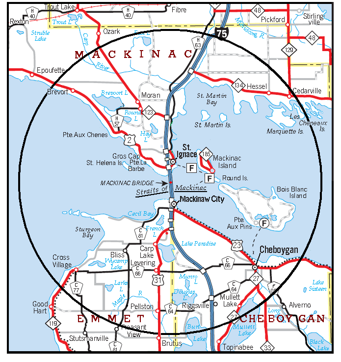
Straits area, as originally defined, see Figure 2 in Appendix A. Maps.
The additional coverage will be directely below the dedication --
i.e., precede the original Table of Contents. It will be added in
a piecemeal
fashion -- i.e.,with no set timetable, rather whenever stone-based
things that appear to be of possible interest are
photographed and
their captions are prepared. The captions and additional
information will be
"drafts" -- i.e., subject to revision as additional data
becomes known.
Brain-Teasers,
Additions and
Revisions:
Four
"brain-teasers," which
include stones, groups of stones, and stone structures, are within the
Straits area of Mackinac
County. Their uses or functions are either unknown or
questioned. Illustrations and "in preparation" texts are in the web
file STONES -- Posers to Ponder,
which is one of the files on this URL.
Additions and
Revisions:
I.
Buildings PublicBuildings
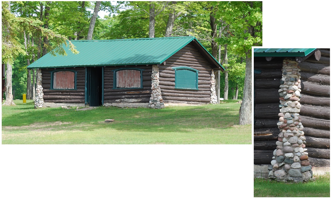
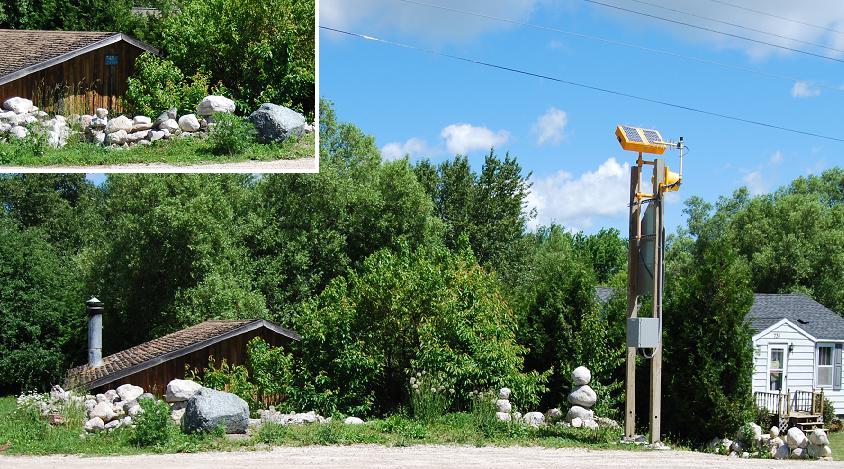
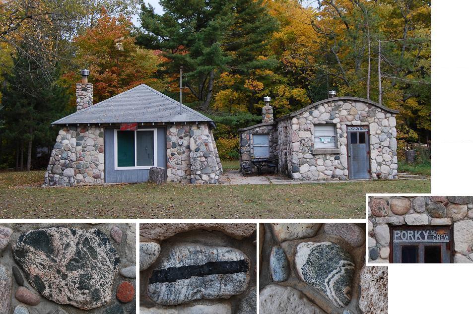
Former "bar".
This
stone-sided building, referred to as a former bar by many nearby
residents, was actually a garage that had a gasoline pump or two in
front of it. The building, which was built in the late 1930s, is on
the south side of the Hiawatha Trail
(Rte. H40) in
Rexton, Hudson Township (NE¼ of Sec.1,
T.43N.,
R.8W).
The
alluded-to bar was an adjoining
part of the original structure. The bar was run by "Buck" Goodrow.
Several years ago, the bar (etc.) portion of the original building was
moved to the north side of Rte. 2, about ¼ mile west of the
junctin of Borgstrom Rd. junctin. Today, that building, which has been
greatly modified, includes a fine example of stone masonry beneath the
bottom of its windows -- see lower photograph. Nearly all of the
stones of this siding are "hard rock" types that are representative of
the bedrock formation of Canada, to the north. All exhibit split
faces.
[The historical information given in the
above caption is based on a conversation with Harold Shoemaker.]
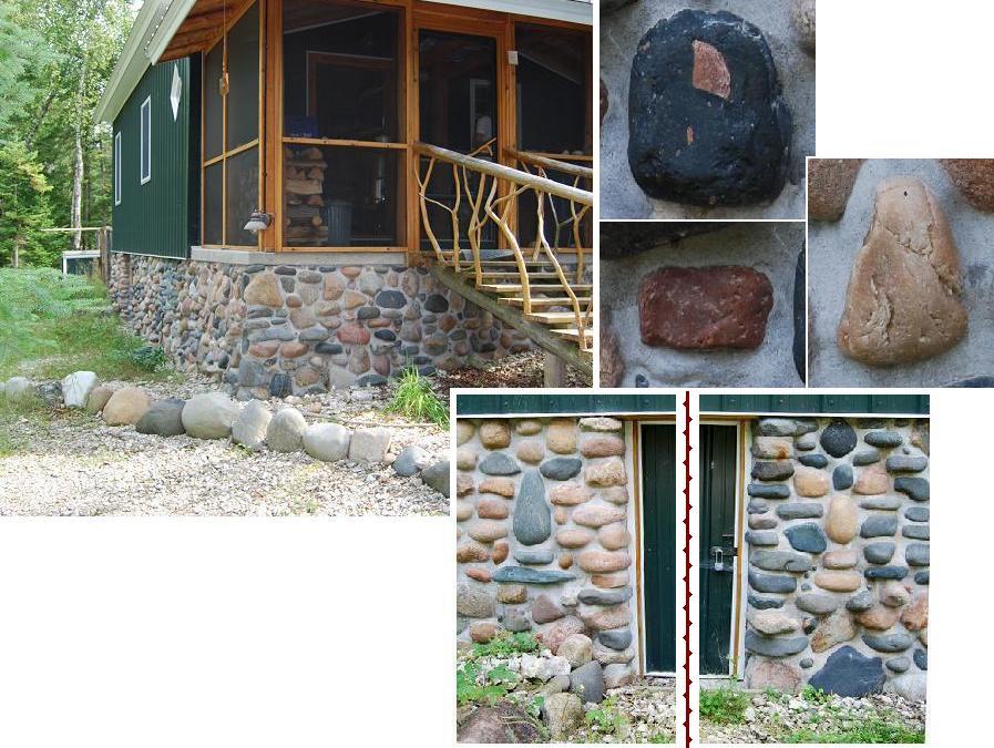
Residences
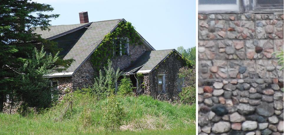
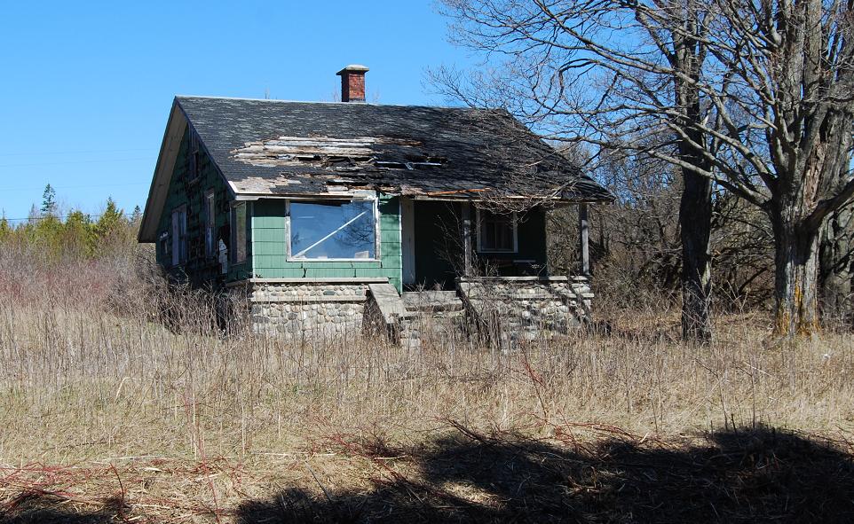
Abandoned farm
house. This house, said to
date back
to the late 20s or 30s and
to
have been built
for a . . . Houck, is
on the north side of Linck Rd., in the SE¼
of Sec.7, T.43N., R.10W. The upper
photograph shows
the west side; the left photograph of the bottom pair shows the
southeast corner ... The
use of fieldstones in this house is especially interesting because the
masonry of lower part of house -- i.e., downward from just above the
level of the eaves -- consists of stones apparently laid course by
course, though
rather randomly, whereas
the area above that level consists of blocks that appear to have been
fashioned like those used in the
residence in Germfask, which is included in the original report
(q.v.).
However, the exposed stones of several of
the blocks used in this house are arranged so they roughly
resemble flowers -- see upper part of the right photo.
[The
historical information given in the
above caption is based on conversations with Linnea Ault.]
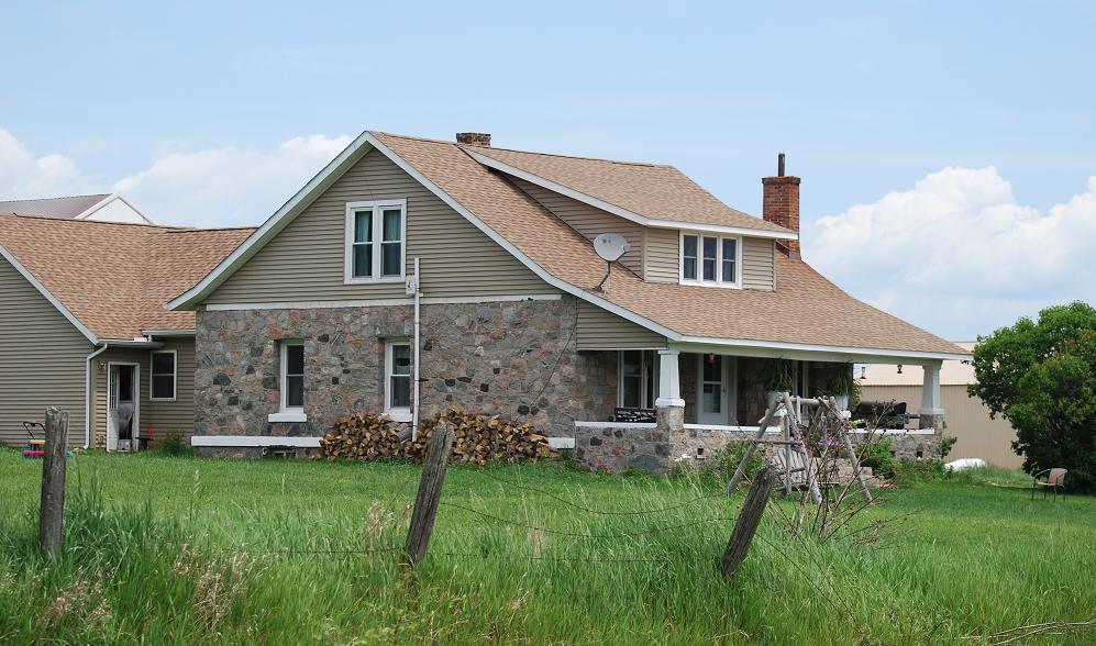
Country Residence. This house,is on the north side
of
McKelvey Rd.
in the SW¼
of Sec.21, T.44N., R.10W. OtherBuildings & Structures
Milkhouse. A
barn on the south side of Swede Rd. (NE¼
sec.15, T.42N.-R.1E.),
once included a fieldstone faced milkhouse, and part of its foundation
extended upward as the wall of its "milk parlor" -- see Cl8, on the Barns
web site
http://stoneplus.cst.cmich.edu/MacCoAlbum/MacCo.Barns.html . That overall
structure is said to have been built in 1911 by Andrew Lofdahl,
an immigrant from the
Åland
Islands.
Root cellar (i.e.,
its remains). This
originally stone sided structure is
located in the NW¼ of Sec.5, T.40N., R.4W. (i.e., 45o55'33"N,
84o46'16"W). The area of the original floor is approximately
20 x 25 feet. Glacial and/or glaciofluvial "hard rock" stones and
stones and slabs derived from nearby sedimentary strata are included in
the masonry. This structure is known to have been one of the
buildings on a former farm owned by William Bryce and apparently used
by at
least two generations of the Cheeseman Family.
A nearby
interesting feature includes parts of an old barbed wire fence that is
now surrounded by several years of growth rings of a couple
trees. It seems likely that this fence dates from the early 1900s
and perhaps to the late 1880s (see Dietrich, 2008, p.78).
[Curtis
Cheeseman, shown in the lower right photograph, directed this structure
and the fence to my attention and
along with his mother, Janice Holle, supplied the historical data about
the structure that are mentioned in this
caption.]
Well
house. This
fine example of masonry, which exhibits split-faces of fieldstones, is
on
the north side of Swedes Rd, northeast of Cedarville (SE¼ sec.7, T.42N.-R.1E.). Nearly all of
the included stones are "hard rock." The structure was apparently
builty by Karl
Rosing, a Scandinavian who came as a homesteader to Les Cheneaux in
1900. See
also the barn on the same property -- especially the foundation
of its south side (see
Cl5, http://stoneplus.cst.cmich.edu/MacCoAlbum/MacCo.Barns.html )
PartsofBuildings
Foundation
The
above building, on Gros Cap Rd. is one of several within the area that
shows how
structures or parts of structures that consist of stone masonry -- in this case the FOUNDATION -- outlast
those made of most other building materials. It is included here
because
some readers (stone masons?) have indicated that not enough was said or
even implied about this fact. [ This building was razed in
2014. ]
The eight chimneys that served structures that no longer exist and the
"Hunting cabin ..." near Reston, which are included in the
original report, are also examples tosupport
the above statement about the lasting
quality of stone masonry. The chimneys
were
originally attached to buildings that were not sided by stone
masonry.
Those buildings "wasted away," were burned, or torn down; the
chimneys
remain! And, if you do not recall, reread what happened to
the preexisting wooden cabin near Reston. In addition,
attention is directed to C18, a barn in Clark Twp.; it is
shown in "Barns of Mackinac County, Michigan: ..." (Dietrich, 2012
-- see http://www.mibarn.net/MacCoAlbum/Mac%20County%20Barns.htm).
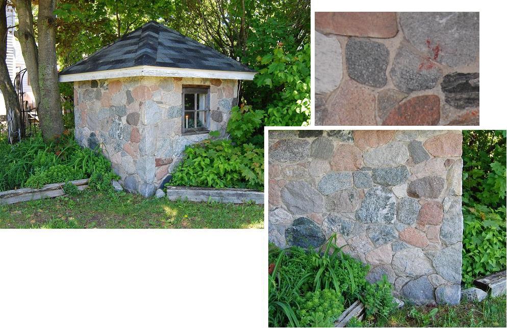
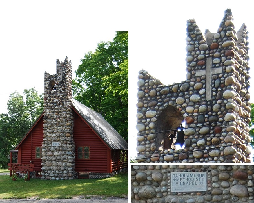
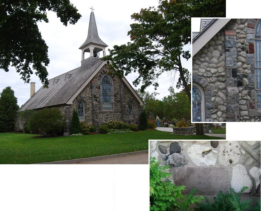
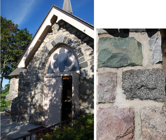
Bell tower (An added subcategory)
This tower, which serves two purposes -- i.e., as a bell tower, as well
as a chimney for a fireplace that is in the church santuary -- is in
Hulbert, Chippewa County. The church,
including its fine stone masonry foundation, and this fine tower were
built in 1935 (see concrete placque
on "tower"). The church treasurer, James Snody, noted that
the stones were brought to Hulbert from Paradise, a few miles north of
Hulbert.
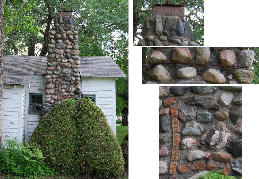
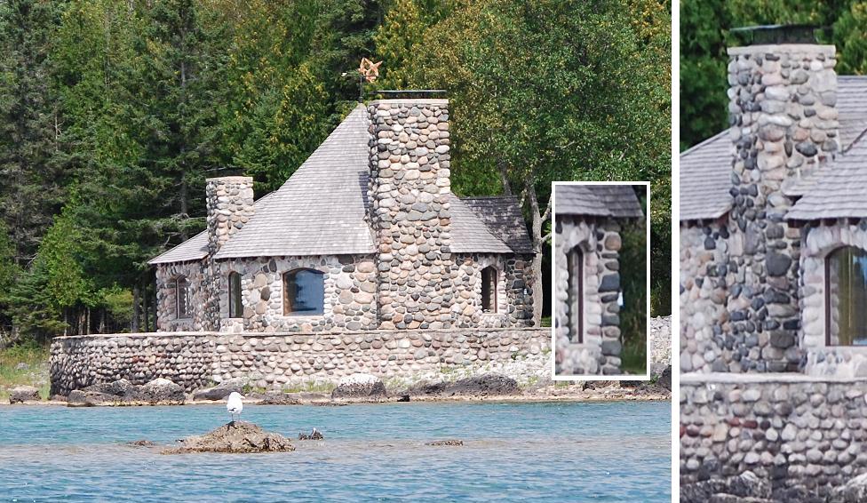
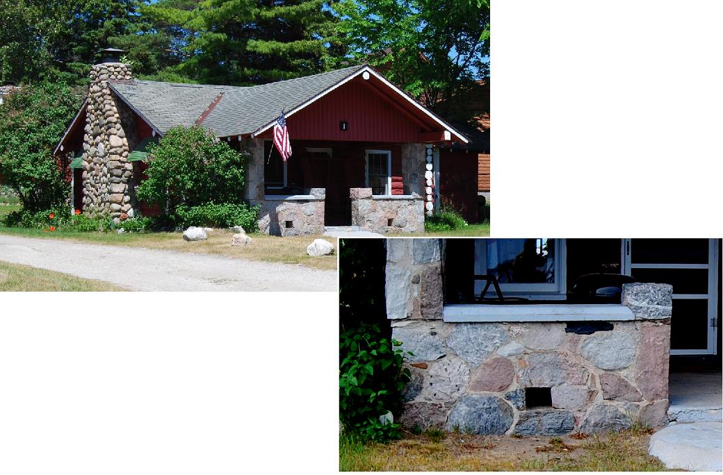
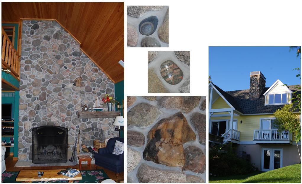
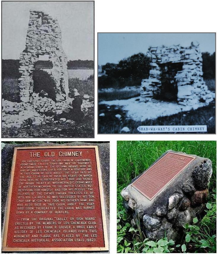
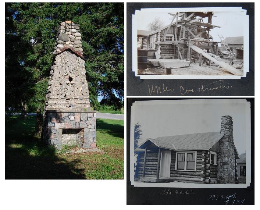
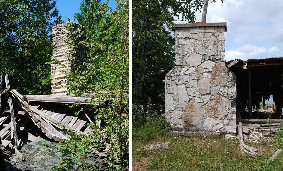
Chimney
"Leaning
Chimney of Brevort
Lake."The above photographs were
taken at
right angles to the "leaning" view shown in the original document,
which is
below this Additions and
Revisions group of photographs and
information. Some aspects of
this chimney that were not evident in
the "leaning" view but are in this composite are: The
diverse makeup of the included stones; the arrangement of the
stones near
the top of the chimney; the strap, alluded to in the next
paragraph; and the "L" (for Litzner) that is outlined by
what appear to
be broken surfaces of bricks.
Additional data about the chimney and house served by it have also
become available. These data provide answers to questions posed
in the
original document: The
house, including the chimney was built during the depression [early
1930s] on land given to Herman Litzner by his father. Herman
is said to have "built the house from excess
supplies he could find and/or
get cheap ... the rocks were just found on the [surrounding] 10
acres of property. [And, so far as the "leaning,"] the chimney
was
straight, but over nearly 90
years, time has taken its toll. We tried to slow its demise by
metal strapping it to the roof peak (which stopped its fall so to
speak)." (Richard Van Overberg, grandson of Herman Litzner, p.c., 19
June 2013).
Corners
The
stone-masonry corners of the above log-sided building have shapes,
settings and apparent function that differ from virtually all the
stone-masonry corners included in the original manuscript (several of
those corners can be seen by using the search word corner). That is to say, the corners of the
previously included structures are continuous with other stone-masonry, such as siding, whereas
the stone-masonry corners of this structure appear mainly to serve as
pillar-like accents of a log-sided building. Most of the stones of the corners of this
building are from nearby glacial and
glacio-fluvial deposits; a few are pieces of nearby bedrock, at
least some of which were likely broken off outcrops as the result of
natural
activities such freezing (and expansion) of water within open
joints.
This building is on the Trout Lake
township campground that is west of Trout Lake village,
in Chippewa Co.; it is thought to "very old" and once to have
been a roof-covered open space (p.c., person currently in charge of the
campground, 2015). Currently, the structure is used
to store the garbage receptacles that are loaned to campers while they
are at the campground.
II.Other
Uses LandscapeAccents
Fountain. This
fountain, on the west side of Church St. in St. Ignace, was fashioned
by Steven Boatner in 2011 and 2012. As can be seen, its more
decorative permanent parts consist largely of large cobbles and
boulders of diverse "hard rocks" from the nearby glacial and
glacio-fluvial deposits. The relatively flat areas that
constitute much of the falls area proper and surround the streetside of
the pool are "limestone" flagstones. The masonry, of which most
of the stones are "hard rock," that surrounds the porch area of the
Boatner's house is also noteworthy -- see upper left photograph.
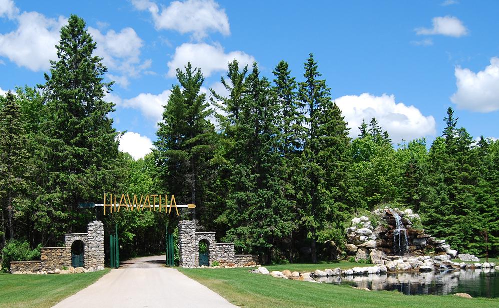
Gateway. This
gateway, the waterfalls and the
pond, which are shown in the upper photograph, grace the entrance to
Hiawatha Sportsman's Club, which includes a
nine-hole golf course. They are on the north side of Rte. 2 west
of Naubinway. The gateway is thought to date to the 1960s;
the waterfalls and pond were added in 2009. A large percentage of
the stones
in these structures are "limestones" derived from relatively nearby
rock
formations; a few "hard rock" stones are also included.
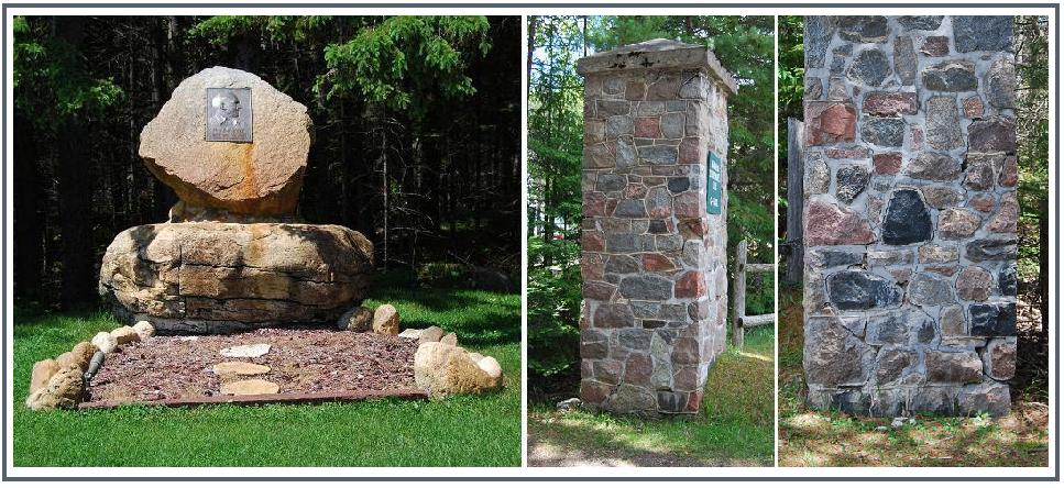
The left photograph of the composite shows the brass plaque-bearing
memorial monument that is west
of the gateway. The plaque bears the following inscription:
Dr. W.E. McNamara / 1877-1953 / Surgeon - Humanitarian - Pioneer
/ Founder of the Hiawatha Club. The photographs on
the right show the columns at the former main access to the Club's
acreage, which is on the south side of the Hiawatha Trail (H-40).
Despite their different character -- e.g., the fact that their
constituent stones exhibit split faces -- it is thought
that these columns were made at about the same time as the
Gateway. As is evident part of the coloumn shown on the right is
in need of repair because of its disintegrating mortar. [Most of
the information in the above caption is based on conversations
with Gary Trombley, who fashioned the waterfalls, and Bobby Beaudon.]
For some things it seems more fun (and thought-provoking) to imagine
than to know WHY. This display is in St. Ignace, on the north
side of Portage Rd., west of the
I-75 overpass.
Walls MiscellaneousUses
Decorative
items.-
"Sculpture" by Randy Dunn. This piece,
fashioned in 2011, is of special interest to me, a long time
petrologist and bird-watcher. It includes a stone, AND it depicts
a bird.
Window display in
preparation for an upscale store, "Decked Out," on Mackinac
Island. Pebbles, cobbles, and small boulders such as these are
gaining apparently ever increasing roles as parts of all sorts of
displays -- e.g., those in museums as well as those in store cases and
windows, and even in photographs for catalogues and other advertisement
media. The stones of this display-in-preparation came from a
beach on Lake Superior.
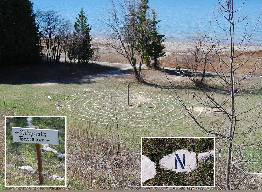
Labyrinth outlined largely with cobble- and small
boulder-sized "limestone" is on the lake side of Pte. LaBarbe Rd.
A few "hard rock" stones and two pieces of concrete are also
included. Letters are on four stones of the outermost circle that
indicate the compass directions; that is to say, lines, which if
present, that would extend from the center of the labyrinth to these
stones woud point in the given directions (see inset example).
This labyrinth is said to have been fashioned by Gary Evans of Ann Arbor in 2011.
A Special Path with a row of angular cobble-sized
stones along either side. This bridal path was on the northern
shore or Lake Michigan, just west of the Straits of Mackinac in mid
August, 2015. Stones like these are rather common here and there
along the nearby lake shore area. A few days later, only the
stones remained; it appears, however, that at least one of them
is missing -- perhaps taken elsewhere, to have a special place . . . .
Monuments & Markers.-
Fishermen's
Memorial. This cenotaph on the
harbor side of
State St. in downtown St. Ignace was erected in 2005. Most of the
constituent stones are relatively small "hard rock" boulders; the
metal "fish," which is mounted on a rod extending from its top, has an
especially eye-catching eye.
Two plaques that describe the intent of this memorial are attched to
the main pillar-like structure: The one on the street side is
shown. The one on the harbor side lists the Fishermen "from
Mackinac County [who] lost their lives while commercially
fishing." Twentyfive in uumber, those included were residents of
Epoufette, Naubinway, St. Ignace, St. Ignace Township, and
Machinac Island. ince 2006, this memorial has served as
the focus of a "spiritual
ceremony" that opens the Annual Fish Festival. As reported in The St. Ignace News (vol. 132, no.
17, p. 1)A local man,
"Darryl Brown, also known by as his (sic) Native American name,
Mididegwe Anamosh, offers a prayer to the Creator using Native American
traditions to start off the Fish Feast ... The prayer ...offered
thanks for the fish and guidance and protection for the fishermen who
make their way of life on the waters."
See also the left side photograph in the Gateway entry under the
Landscape Accents subheading.
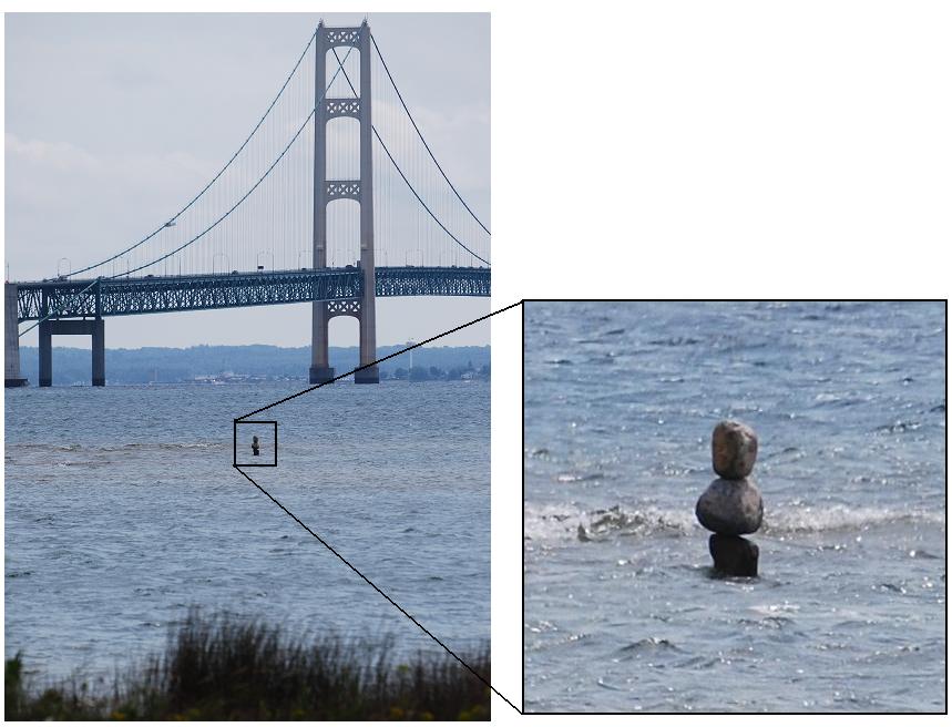
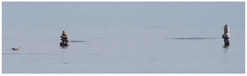
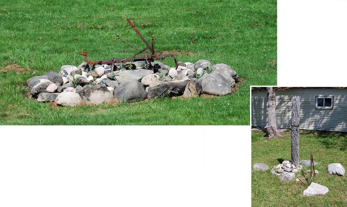
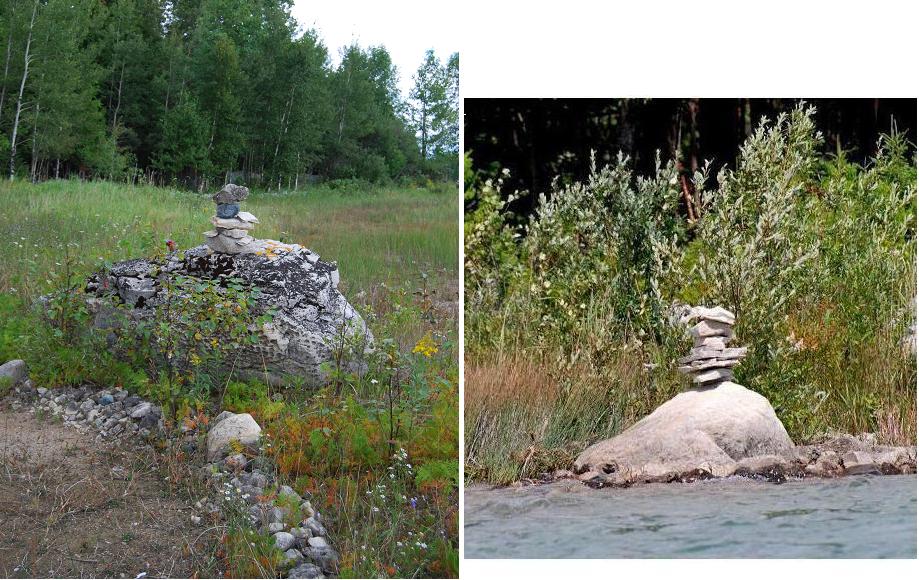
Cairn-like
stack of stones, created in late July, 2012. This stack was in
a
small, shallow bay offshore from Boulevard Drive in section 24,
T.40N., R.4W. As a WW-II veteran, and I admit that I know not
why, this led me to recall several of the places I saw "Kilroy
was here." Furthermore, as I remembered how some of those
"signatures" were short-lived (e.g., crossed-out or removed), my
recollection became so-to-speak even more timely; this was so
because a few days later (by August 3rd), this cairn was no longer
present. However, a three-stone stack, which I had not seen
before, was offshore from the Boulevard, fairly near the "Big Mac"
Bridge; I suspect it was put there to mark a shallow sand bar in
the
Straits -- See below.
The next evening
(August 4th), a
small stone had been added to the three-stone stack, AND an
additional stack, a photo of which is shown below, was on the same bar,
about 20 feet to the left. As can be
seen below, the
more recently created stack includes more stones than the first one on
the bar. In any case, as I told my "kids," its presence reminded
me of what my
Grandmother Vincent used to tell me when I was trying to do something
-- frequently, something not all that "smart" -- that one of my older
cousins had done: "Monkey see, monkey do!" [I wonder if
this old saw had anything to do with the origin of the verb toape and its various
forms.]
During
the night there was a
storm. On the morning of August 5th, neither of these
stacks was on the bar.
- - -< + > - - -
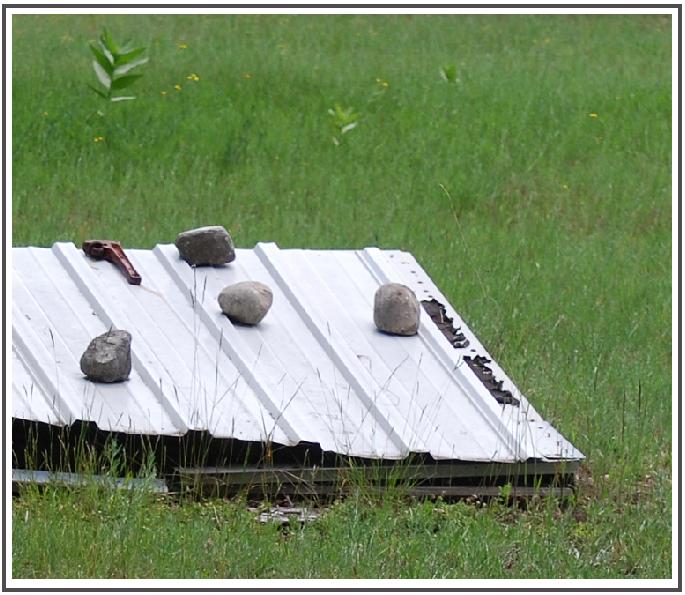
Weights
Stones used as
weights to hold something down can be seen here and
there in many places within the county. This example is on the
south side of Town Hall Rd. across Derusha Rd., and the old Townhall,
in Hendricks Twp. (Sec. 9, T.43N. R.7W.)
Table
of Contents (included to
facilitate searches).
PREFACE
INTRODUCTION
I. Buildings Public Buildings “Little Stone
Church,”
Mackinac Is.
Restaurant - Jockey Club,
Mackinac Is.
Former Cobblestone
Café & Motel, St. Ignace
Former Mackinac County
Airport Terminal
Former Store on Mackinac
Trail Residences
Farm House,
Portage Rd., St. Ignace
Residence, North State St., St.
Ignace
Residence, northwest of Hessel
Residence, Cedar Rd., Hessel
Residence, Grove St., Cedarville
Former residence, Cheeseman Rd.
Summer cottage, Brevort Lake
Summer home, Marquette Is.
“Blockhouse,” Marquette Is.
“Cabin” on Bois Blanc Is.
Officers' Stone Quarters, Mackinac
Is. Other Buildings & Structures
“Blast Shack,” west of
Brevort
Fort Mackinac
Blockhouses, Mackinac Is.
Icehouse & woodshed,
Marquette Is.
Former kilns:
On Mackinac Is.
On Rabbits Back stack
South of Kenneth
“Powder Magazine,” Mackinac Is.
“Playhouse,” Avery Point, Hessel Bay
Root cellar, west of
Cedarville
“Warehouse,”
Marquette Is.
What?, St.
Ignace (Now #4 of
"Brain-Teasers" in Update section)
What??, northwest of West Lant
Rd. (Now #3 of
"Brain-Teasers" in Update section) Parts of Buildings
Partial facings:
LaSalle High School, St. Ignace
Residence, Huron St., St. Ignace
Residence, Duke's Rd., Moran
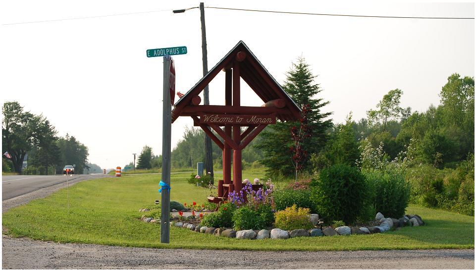
Residence, East Adolphus St., Moran
House, East Lake
Summer Place, Les Cheneaux Islands
Vacation home, northwest of Brevort
Residence, Adolphus St., Moran
Foundations & Porches:
Loyola Catholic Church, St. Ignace - foundation
Cabin-home, Mackinac Trail - foundation
Summer home, Bois Blanc Is. - foundation plus
Trailer, Cedarville - faux foundation
Residence, Schoolhouse Rd., Brevort - foundation & “stoop”
Residence, Bertrand St., St. Ignace - porch
House, Martin Rd. (west branch) - porch
Cottage, Hessel - porch & chimney Chimneys & additional
uses:
Diverse chimneys - four examples
“Leaning
chimney of Brevort Lake”
Stairs & pedestals, Rockview Rd., north of Hessel
Indoor Fireplaces:
Former Mackinac Co. Airport Terminal, St. Ignace
Summer home, Hessel
Summer home, Hessel
Residence, Rockview Rd.
Summer home, Bois Blanc Is.
Fire-proof backing for stove, north of Brevort
Former Fireplace-chimneys:
“Chimney
Point,” Marquette Is.
Golf Course, St. Ignace
Duke's Rd., Moran
Brevort Lake and “Sofie's Tavern,”
Pine
River
Rabbits Back Peak Peninsula
State St., St. Ignace
Martin Lake Rd. and Gros Cap
II. Other Uses Landscape Accents
Boulders:
Boulder entities - Graham Ave.,
St.
Ignace and Brevort Lake Rd., west of Moran
Boulder
plus - Mackinac
Is.
Boulders,
group of
- Schoolhouse
Rd., Brevort
Boulders
atop boulders -
Duke's Rd.,
west of Moran and Wartella Rd., east of Moran
Small
stones atop a
boulder -
Ponchartain Shores Small stones atop a boulder
Rubble
atop rubble -
Mackinac Is.
Boulders
that welcome -
Wartella Rd.,
east of Moran
Boulder
deterrents (No
parking) - Bois
Blanc Ferry landing area
Boulder
deterrents (No
trespassing) -
St. Ignace deterrents
Driveway
“dots” - East Lake
Rd.
Driveway
“dots” - Gros Cap Rd.
Painted
“dots” -
St. Ignace
Lines
of stones -
Cedarville (2 entries)
Waterfalls
&
cascade - Mackinac Is.
Waterfalls
&
stream - Woodland
Subdivision, Cedarville
“Dry
waterfall" - Church Rd., Moran
Patio-walkway
- Bois Blanc
“Total
landscape” -
LaVake Rd.
Cobbles:
Walkway
- Bois Blanc
Walkway
& steps
-Moran
Stones
on steps - St.
Ignace
Planters
&
atone-bordered
flower beds:
Duke's
Rd., Moran; Huron
St., St. Ignace;
Gros Cap Rd.; & Church Rd., Moran
“Frame”
around flagpole -
LaVake Rd.
“Frames”
around ...
- Pte. LaBarbe
Rd.; Charles Moran Rd., Moran; & Brevort Lake Rd.
“Frames”
around ...
- Cheeseman Rd.
& East Martin Lake Rd.
“Frame”
around Moran
“Welcome ..” etc.- Rte.
123, Moran - “frame”
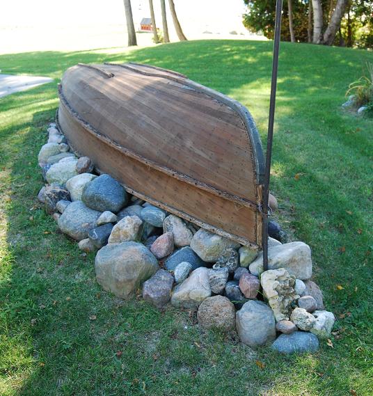
“Frame”and
base for old
boat - Pte. LaBarbe
Rd. - “frame”
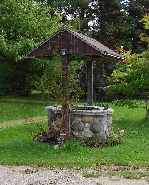
“Wishing
well”
Evergreen Shores
Pillars
- Mackinac
Is.; Pte.
LaBarbe Rd.; & Allenville
“Pillar”
- Cedarville Walls
Stone
“fence” - Church Rd., Moran
Dry-laid
wall - Kenneth Rd.,
Hiwatha National Forest & Pte. Aux Chenes
Dry-laid
wall - Hessel
Culvert
headers - Moran
Wet-laid
walls - Fort Mackinac,
Mackinac Is.
Wet-laid
wall - near “Chimney Point,”
Marquette Is.
Wet-laid
walls - Duke's Rd., Moran
& Huron St., St. Ignace
Wet-laid
walls - Martin Rd.
extension
Wing
walls (former) -
Mackinac Trail
Walls
in Cemeteries - Grace
Brethren Cemetery, near Ozark & Gros Cap Cemetery
Wall
in Cemetery - Brevort
Township Cemetery
Diverse
walls - Mackinac Is. (2
composites) Miscellaneous Uses
Shore
Protection and Docks
Boulder
and/or rubble
piling - St.
Ignace, Brevort
Lake, & Brevort River
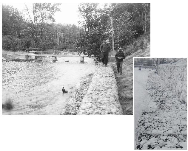
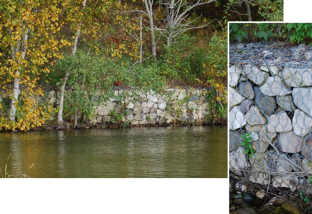
Gabion
“wall” -
near Damsite, Brevort Lake outlet area
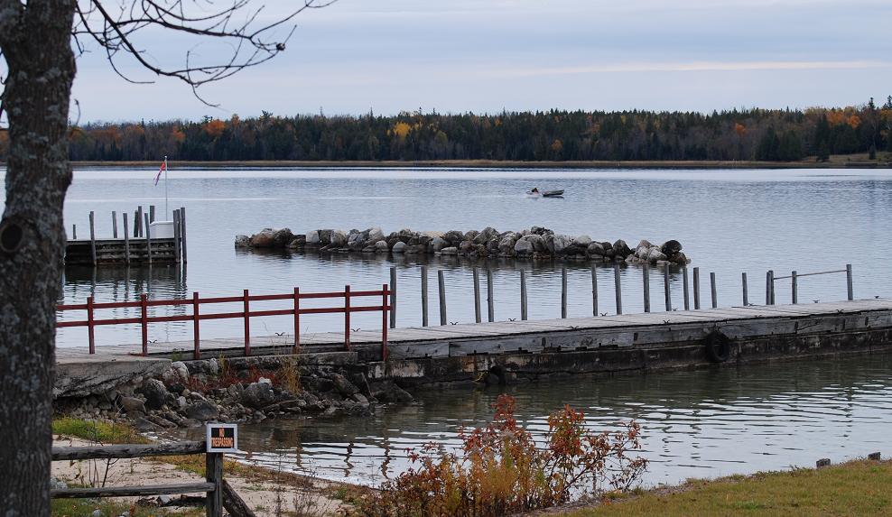
Breakwater, off-shore, Hessel
Pond
side - Black Point
Rd., west
of Moran
Former
dock -
Brevort Lake
Crib
docks - Hessel
Fire
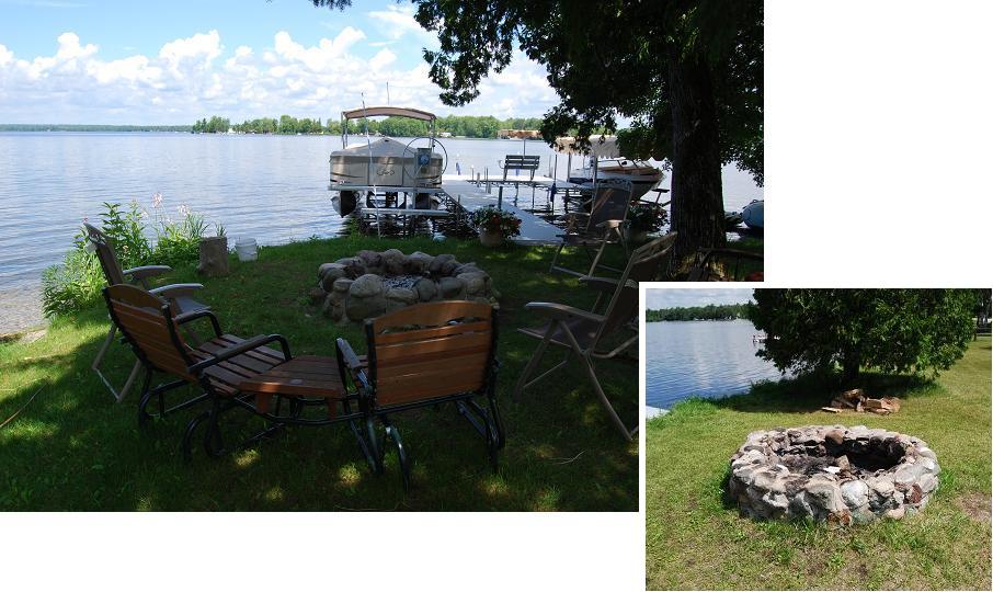
circles and Outdoor Fireplaces:
Loose
rubble &
fieldstones -
Search Bay, Hiawatha National Forest & Ponchartrain Shores
Large
one, loose stones -
Schoolhouse Rd., north of Brevort
Firecircle
with mortar -
Brevort
Lake (2)
Outdoor
fireplaces -
Marquette
Is.& Worth Rd., northeast of Brevort
Outdoor
fireplace - Pte.
LaBarbe
Rd.
Outdoor
fireplace - East
Lake Rd.
Decorative
items:
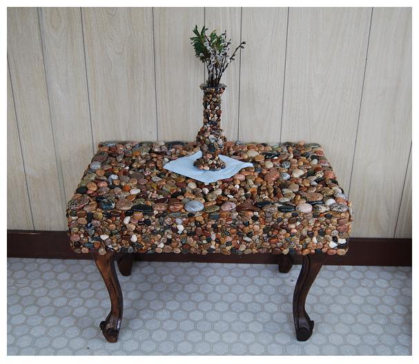
Pebble
“mosaic” table &
vase - Moran
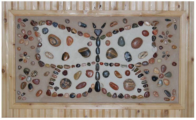
Framed
“hanging” - Allenville
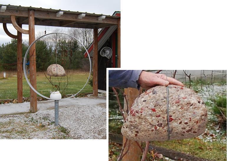
Boulder
pendant
- Webb Rd.
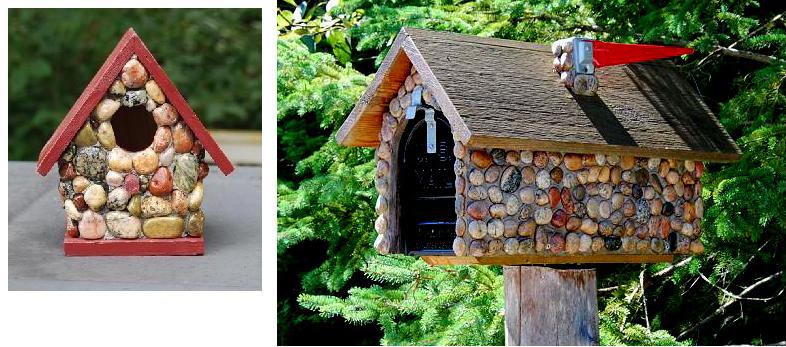
Birdhouse,
mailbox, plant pot
& birdbath - Hessel, Hill Is., Brevort
Lk.
Rd. & Cedarville,
respectively
Birdbath
- Bois
Blanc
Table
tops -
Cedarville
“Rock garden” - Evergreen Shores
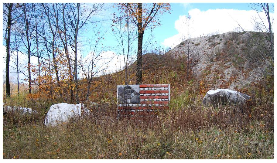
Stylized
fauxstone
... replica
of “Old Glory” - Chard Rd.
Monuments
& Markers:
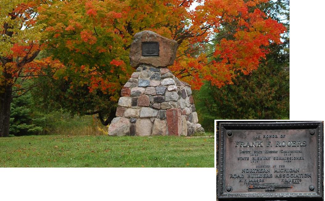
Rogers
monument -
Mackinac Trail
Cemetery
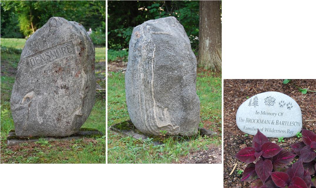
monument &
commemorative boulder - St. Ignace & Cedarville, respectively
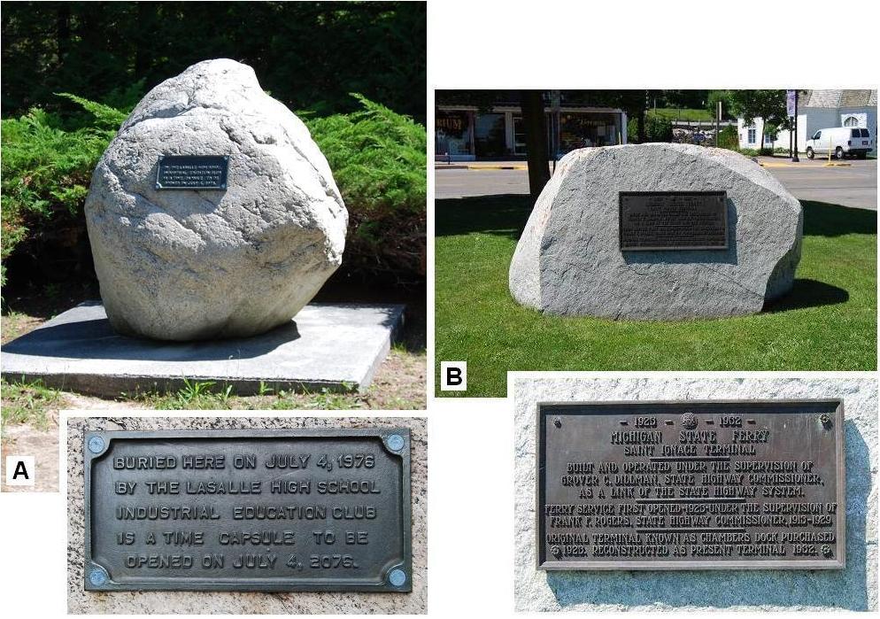
Bicentennial
Time
Capsule (Father Marquette National Park) &
Michigan State Ferry ... - St. Ignace
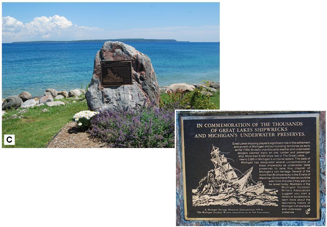
Shipwrecks and
Underwater Preserves - St. Ignace
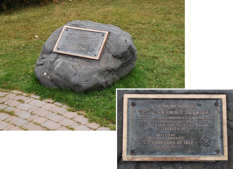
Unknown
Soldiers
(1814 battle) -
Mackinac Is.
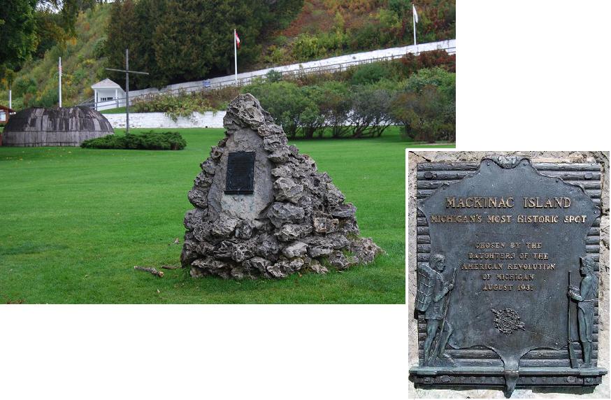
“Michigan's most historic spot”
- Mackinac Is.
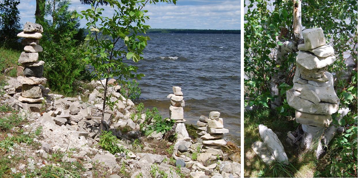
Cairn-
and Inukshuk-like stacks of stones:
Cairn-like
stacks -
Brevort Lake
Cairn-like
stacks -
Hessel
Cairn-like
stacks -
Kenneth
Rd.
Cairn-like
stacks
-
Mackinac Is.
Piles
- Cheeseman
Rd.
Inukshuk-like
stacks -
Mackinac Is.
Weights:
Small
and medium boulders
- East
Lake & Gros Cap
“Wow”&
Worry Stone - Brevort Lake &
portable, respectively
“A matter of
tangential interest,”
Pte. Aux Chenes
III. Nearby Fieldstone Uses of
Special Interest.
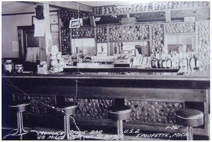
Monck's Stone Bar, formerly in Epoufette, Mackinac Co.
Hunting cabin plus, Hiawatha
Trail, southeast of Rexton, Mackinac Co.
House, Germfask, Schoolcraft
County
House, west of Fibre, Chippewa
County
Pillar & wall, Pt. Iroquois,
Chippewa County
Stone “fences,”
south
of Goetsville, Chippewa County
Residence & wall, DeTour
Village, Chippewa County
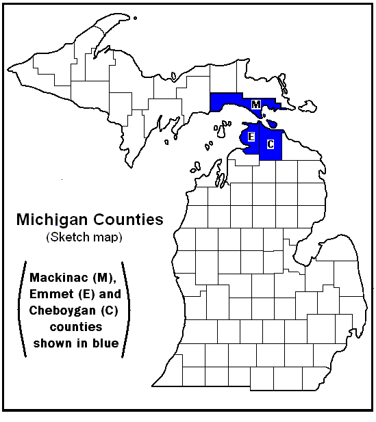
APPENDIX A. Maps
Michigan
Counties
Area covered
APPENDIX B. Additional “Miscellaneous
Uses” of
Fieldstones within the Area
APPENDIX C.Some Rocks and Geological Features
exhibited by fieldstones shown in photographs GLOSSARY
REFERENCES CITED
ADDENDUM
PREFACE
Robert
Brown, my son-in-law; Krista Brown, my daughter; Rick
and Kurt Dietrich, my sons; Charles Brown, a St. Ignace attorney;
Chuck Cullip, a St. Ignace businessman; John Evashevski, St. Ignace
High School teacher and coach, retired; Charlie
Fowler, St.
Ignace middle school principal, retired; Paul
Kreski, Consultant, Mackinac Environmental;
Mike
Lehto, St. Ignace elementary school principal, retired; Phil
Porter,
Director, Mackinac
State
Historic Parks; Buck Sharrow, guide
and carriage
driver on Mackinac Island; and Jim
Vosper, author and long time resident of Bois Blanc Island,
accompanied me while I visited and
photographed some of the buildings and other features included in this
album. Krista
and Bob viewed an early
and the next-to-final draft of the material, provided several
interesting facts about the area and gave me suggestions that
increased and
improved the coverage. Charlie
Brown
was especially helpful because of his knowledge about
the area, where he has spent most of his life; among other
things, he supplied reports and records, some of which would have
been
difficult to get elsewhere. Bob Brown, Charlie Brown,
Chuck Cullip, John
Evashevski, Charlie
Fowler and Buck Sparrow took me to
some localities that would have been extremely difficult for me to
get to alone -- Bob Brown and Charlie Fowler by boat##; Charlie
Brown,
Chuck Cullip and
Paul Kreski by
4-wheel drive vehicles;
John
Evashevski by
his four-wheeler;
Buck by horse-drawn carriage (carriage
and
horses courtesy of Mike Young, Frankenmuth
automobile dealer). David
Ginsburg, Research Librarian
Emeritus, Central Michigan University, helped me find some rather
obscure references and checked the format of the References
Cited. Krista
Brown,
Rick and Kurt
Dietrich and Reed Wicander critiqued the pre-final draft
of the material included. I
gratefully
acknowledge and thank each of these people for their
contributions.
Colonel
Curtis Cheeseman and his wife Caroline
kindly
provided me with a place to stay in October, 2009, when I did the
preliminary data collecting.
The
following people aided me by
supplying information
and/or in other ways as I collected information and took the
photographs: Hugh Anderson, Jon Arnold, Ray & Kim Arnold, Katherine
(née Lehto) Babcock, Donnelda
Baer, A.J. Baker,
Mary Baker, Earl Bayush, Jack Bickham, Richard
Beruning, Larry Bigelow, Steve
Bird, Stella Bishop, Chalie Bomeister,
Gertrude Boyd, Ollie
Boynton, Prentiss M. Brown,
Jr., Mallory Burkolder, Geraldine L. Collins, Chuck & Connie
Cullip, Tom Della-Moretta, Jack Dougherty,
Jerry Eifler,
Pat
Emory, John & Pam Engel, Vern
Erskine, Lucy
Evashevski,
Barb Foster, Charlie & Karen Fowler, Dave,
Janet &
Chet
Garen, Violet ("Marie") Gorman, Janet Hagen, Carol Hamel,
Charlie Hanson, John
Hessel, Mary Hill, Dan
Hockett, Vicky Hough, Oliver House, Cathy Johnson, Kathryn (née
Goyer)
Johnson, Tom
Johnson,
Theresa Kelley, Diane Kreski, Nick & Laurel LaChapelle, Elmer
Lamoreaux,Steve & Gretchen Lauer, Michele Ledy,Julie
Lipnitz, Patricia Litzner, Louise Lowetz,
Mike & Derinda Mann, Phyllis & Ed Massey, John &
Madlyn Masten, Paul & Kay
Matelski, Jennifer
McGraw, Jim Mertaugh, Bob Monck,
Lois
Movalson, Robert J. Muter, Aggie O'Brien,
Tracy Olmstead, Chuck Orr, Barb & John Palmer, Mabel
Pechta, Mark
& Wayne Peterson, Al & Pam
Reilly, Roxanne
Powers-Tallman, Ervin Rose,
Robert St.Andrew, Steve Sjogren, Dan Smith, Elaine (née Dowd)
Sprague,
Michael
Springsteen,
Jon Steinbach, Dick Sterk, Dick & Karen Tobin, Andy Valentine, Elna
VanHouten, Mark
Vonderwerth,
Betty Vosper,
Bernice Weiss, Nancy
(née Goyer) Welch, Ken
Welton, Alan & Janet
Werkheiser,
Eldon
Windberg and Robert L.Wirt. I thank each of them for their
gracious
responses to my questions and their additional help.
In addition, it seems only
appropriate to add a "hats off" to the masons and others,
both those mentioned in the captions and those unnamed,
who used
fieldstones to create the buildings, parts of buildings, and other uses
of stones noted in this album. Their creations made my taking
the
photographs and compiling the data a satisfying experience.
INTRODUCTION
This
is
the first of three anticipated photograph albums to
record diverse uses of fieldstones within approximately 25 miles of
the
Mackinac -- widely known as the "Big Mac"-- Bridge. This bridge,
which connects Michigan's Upper and Lower peninsulas,
crosses the Straits of Mackinac, which connect Lake Michigan and Lake
Huron (See Map 2 in
Appendix A). This volume covers
the Mackinac County --
i.e., the Upper Peninsula -- part of this
roughly circular area. Volumes
2 and 3, when and if completed,
will provide similar coverage for the Cheboygan and Antrim
counties
parts of the encompassed area.
My
coverage
of the uses of fieldstones within the area should not be
considered comprehensive. This is true because 1.several
buildings other than those illustrated also have fieldstones as
functional
and/or decorative
parts; 2.thousands of
fieldstones, other than those shown, are used as landscape accents;
3.fieldstones
very likely have
had, or
are having, roles other than those
recorded herein; [and]
4. additional
fieldstone-faced buildings, not seen by me, may occur within the
area.
Indeed, more comprehensive compilations may be warranted, especially
for some of the relatively small parts
of this area -- e.g., the Cedarville-Hessel area and Mackinac
Island -- each of which could be beautifully illustrated. These
projects remain on my "Futures"
list.
A
few uses of fieldstones in
Michigan's
Upper Peninsula that are outside of,
but within relatively short distances of, the
~25-mile circle, made
me want to extend the radius of the circle. Critical
considerations precluded that effort, at least for the time
being. It also,
however, led
to my
decision
to
include seven of those uses in this volume. They
are in outlying areas of
Mackinac County and adjoining Schoolcraft
and Chippewa counties. Perhaps
their being included herein will whet the
imaginations of others and cause them to extend my coverage to
include the diverse uses of fieldstones within these "outlying"
areas.
Fieldstone,
as used in this album, refers to stones of all sizes that are naturally looseon or near
the earth's surface. Pebbles, cobbles, boulders and rubble
are
included.
"On or near the ... surface" includes stones that are atop or
surrounded by soil, along or
under lakes or streams, and within sand and gravel pits.
A
large
percentage of the
fieldstones within this area consist of
sedimentary rocks, a large percentage of which are dolostones or
limestones. Although, as a petrologist, I am reluctant to do
this, all of these stones are referred to as "limestone" within this
album. This is done because 1.Except
for geological reports, virtually all publications that mention these
rocks within this region -- e.g., their uses on Mackinac Island --
refer to both of these rocks as limestone; consequently, my
following suit -- though including
the term within quotation marks -- seems
reader-friendly for most of those who are likely to peruse this
album.
[and] 2.The time that would have been required to check the
innumerable stones that consist of one or the other or both of these
rocks whose uses are recorded herein would have been misspent,
if, indeed, it could have been done. Most of these rock
fragments -- i.e., rubble -- occur as debris that is either
directly
above the bedrock formations from which they were separated by
weathering and erosion or where they were deposited after having been
transported, for the most part only
rather
short distances, from the rock formations from which they were
derived. Most of that
transport was
by downslope movement plus or minus stream and/or lake
activities. The
other fieldstones within the area consist largely of cobbles and
boulders that were transported
from Canada into this
area
by glacial ice during the last "Ice Age." They
were deposited either directly
from the
melting ice sheet (i.e., they
were merely dropped down) or by
streams made up wholly or largely of melt water from the glacial
ice. Most
of these stones consist of
igneous or
metamorphic rocks or migmatite, which are widely
referred to as "hard
rocks."
The
uses of
these fieldstones are treated in two main
sections: I. Buildings -- i.e., fieldstone-faced buildings
and parts thereof plus similarly constituted building-like
structures and
II. Other Uses -- i.e., fieldstones that are used for other functional
and/or
decorative
purposes, such as
Landscape Accents and Walls. Except for
introductory
statements for these two main sections and a few of the subsections,
the only
text
that is given is in the captions.
Close-up
photographs of
some of the typical and particularly interesting stones, which as a
petrologist I could not resist adding, are included
with some of the
main photographs. As I have told several people while
examining the stones of their buildings etc., "I could teach a
course in petrology using these stones!" Along that line, a list
the
rocks that constitute these specially illustrated stones is given in
Appendix C.
~~<<+>>~~
I.
BUILDINGS
The
illustrated
buildings are those that I saw as I drove or was driven along the
public roads
within the area or was told existed and directed to by residents who
knew I was making
this compilation. Therefore, it seems quite possible that
additional
stone-faced buildings occur
within the
area -- i.e., ones I did not see them because they were obscured
by trees or because they are located along roads marked as, for
example, "Private
Drive - Keep Out." If
anyone knows of additional stone-faced buildings within the area or
of additional uses of fieldstones,
either past or current, please let me know. I will try to visit
the buildings and, upon getting information about
the uses, will include
photographs of them, or at least mention them, in an
addendum of updated information. PUBLIC BUILDINGS
"Little
Stone Church" is the name widely
applied to
this Union
Congregational
Church on Mackinac Island. Established in 1900, the building had
its
cornerstone laid August 2, 1904. The stones, said to have been
collected from the Island, include relatively angular as well as
rounded rubble and also several "hard-rock" stones. The
originally rubble fragments are the most common constituents of the
main walls. The "hard-rock" fieldstones, most of which are
dressed, are the predominant
constituents of the other elements, which are commonly considered
chiefly decorative -- e.g., the stones around the windows and main
entrance, the corner buttress-like structures and the two vertical
accents that are between the large window and the two smaller windows
on the front façade. Note also the fact that the sill of
the window is concrete.
The
close-up on the
lower right of the top composite includes the
cornerstone. The two other photographs provide views that
exemplify the diversity of the shapes and compositions
of the stones of the large expanses of the church's outer walls.
The two
lower
photographs show the main entrance, which is bordered by
dressed, chiefly "hard-rock" stones and a close-up of similarly dressed
stones from another of the so-to-speak architectural accents.
Restaurant. This
subsidiary restaurant is part of the Grand Hotel Complex on Mackinac
Island. It is my understanding that in the past it has been known
under several different names. Currently, I have heard
islanders refer to it as either the "Jockey Club" or the "Grand Stand." I was
unable to get access to the structure so can only suggest, on the basis
of photographs, that most of the stones appear to be "limestone" rubble
that has been rounded, probably by lake-shore
activities. Both the shapes and sizes of the stones between the
windows range rather widely. Contrariwise, the single course of
stones directly above the windows
consists of a single course of stones with similar shapes and of
approximately
the same size.
Former Cobblestone
Café & Motel. These
two structures were formerly south of Indian
Village, on the
lake side of State Street in St.
Ignace. They were
built in the late
1920s or early 1930s and razed after the 1957 tourist season. Many of
the stones of the café
were small boulders rather than cobbles, as the name suggested.
It
appears from the photograph, however, that at least many of the stones
of
the second building were cobbles.Harry Leafdale is
thought to have been the builder, including the masonry.Ed and Ida Quay were the original
owners. In an advertisement
in Before the Bridge(Kiwanis
...,
1957, p. 199), it is
noted
that "this cafe has been in operation since 1929," and Don Vaughn
is noted as the owner. The
three unit motel is said to have been a garage when it was first
built.(Illustration is a photographic copy of a
postcard in Phyllis Massey's collection.)
Former Mackinac
County
Airport Terminal at St. Ignace. As noted on
the sign, this
fieldstone-faced building dates to 1934. It was the airport
terminal
until 2001. The stones are virtually
all "hard-rocks." The close-ups beneath the main photograph
show: left, a
breccia; center, a
"bull
--i.e., vein -- quartz" fragment; [and] right, epidote (green) veins
transected by quartz (off-white) veins, both within the granitic rock
that is to the right of the "bull quartz" in the center close-up.
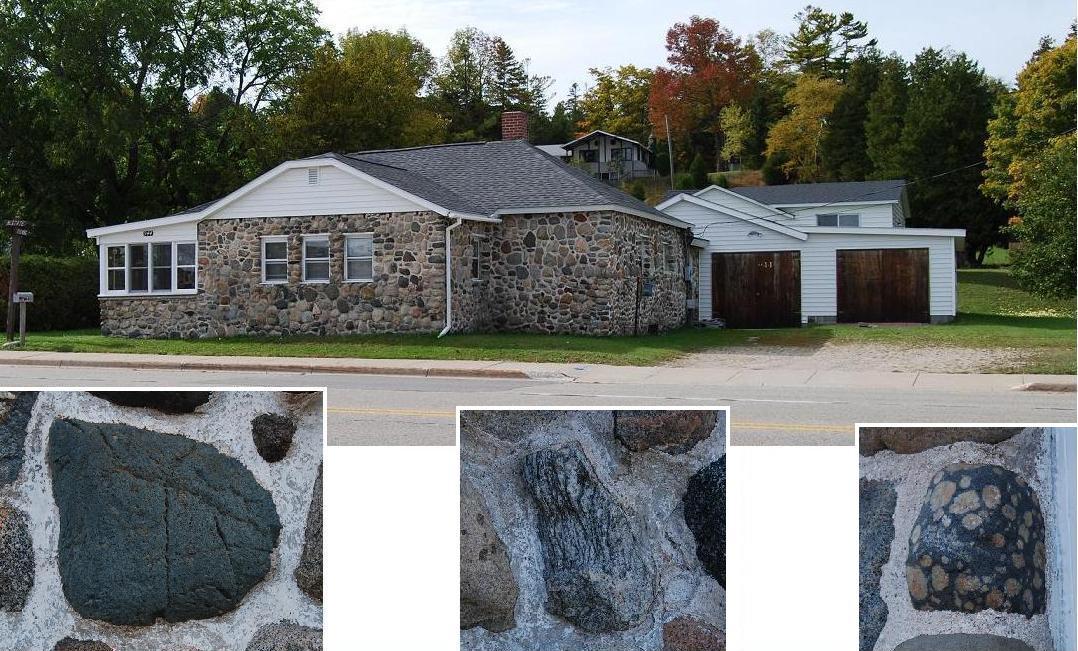
Former Store. This
building,
currently used for storage, is southeast of the southern junction of
Gorman Rd. with the Mackinac Trail. The early history of the
building is unknown. From at least the mid 1930s to the late
1960s, it was, at least intermittently, a store. People known to
have run the store include Fred Houle, Janet
Steele, Eugene and Hattie Mills, and Margaret Shreve.
Records and people with whom I have talked indicate that the building
may date back to 1907 and perhaps to the 1800s. Two
people think that the store was also once a Gulf gasoline station when
this
part
of the Mackinac Trail was the main road -- i.e., former Rte. 2 --
between St.
Ignace and Sault
Sainte Marie; another person, however, believes that that station
was, instead, at the northern junction of Gorman Rd. and the
trail. Kevin Montie (p.c.
July, 2012) indicates that this store was run by the Wiggins during the
1960s, but that soon thereafter they moved the business about two miles
northward to an area on the western side of Mackinac Trail that is
about
one-quarter mile north of the
bridge over the Carp River (see "Wing
walls occur...".). He also said that no gas
station was with the former store at that time, but that gasoline pumps
were at the Carp River location. As a matter of fact, an old sign
gasoline station sign is still there.
Most of the
stones of this
building are "hard
rock" boulders, very likely from nearby fields. RESIDENCES
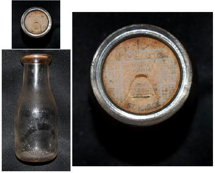
Farm house. This house, on Portage Rd.,
St. Ignace, is said to date back to at least the first quarter of the
20th century. Long-time residents of St. Ignace call it the
Porter House, after its long-time residents. Lee Porter, a dairy
farmer, delivered milk to many families in St.
Ignace and the surrounding area for many years. A photograph of
one of the milk bottles, which is in the collection of Ollie Boynton,
is shown below the two main photographs.
The
kinds of stones included indicate that they probably
came
from glacial and glacio-fluvial deposits in nearby fields.
The middle photo, a close-up,
shows the coarseness
of the aggregate used in the original mortar
and the general character of the finer mortar that was added later to
repair parts of
the
original mortar joints. The
coarseness of the original aggregate is unlike any I have seen
elsewhere except in parts of Hadrian's Wall near
Newcastle, northern
England.
Residence on the
west side of
North State Street in St. Ignace. Harry Leafdale, who lived in this house
for many years, is thought also to have been the builder and
mason. The house dates back to at
least the
1930s.
Residence north of Rte. 134,
northwest
of
Hessel. The original stone-faced home was built for
Albert Linberg
during the 1920s or 1930s. The stones, virtually all "hard
rocks," are thought to have been brought in from the Goetzville
area, Chippewa County. The pattern of these stones roughly
resembles what I
have referred to as the "Isabella
polka
dot" pattern in the central part of the Lower Peninsula of
Michigan
(Dietrich, 2008
-- cf. Fig H2,p. 23).
Mary Hill (p.c., July 2012) has
informed me that the mason who built this house was brought to this
area from Gladwin County, which is just northeast of Isabella County,
where the alluded to "Isabella polka dot" pattern is common and was
so-named.
Residence on Cedar Rd.
in Hessel. The
lower floor, which is stone-faced, is the original house. The
second floor is a later addition. Trees and
other growth precluded my getting an overall view of this house. The
stones of the house are a mixture of "hard-rock" stones and rubble.
As shown on
the left, which is part of the back of the house, most of the stones
are "hard-rock" cobbles, a rather large percentage of which have
relatively
flat
exposed surfaces. The source of the flat slabs of "limestone" at the
corner and along the sides of the windows is unknown; but,
considering
their shapes, it seems likely that they were parts of relatively large
rubble "boulders" like those that occur widely within the area -- e.g.,
along the nearby lakeshore.
Residence on Grove St.
in Cedarville. This
cobblestone-faced house is said to date to
the mid-1940s. A large percentage
of
the component stones are "hard rocks." The close-up
photographs show
the
following characteristics: Left, A typical section
of the cobblestone facing. Right,
A corner, where relatively flat, roughly discoidal, stones were
used.
Former residence in a wooded area
north of
Cheeseman Rd. This house is known to pre-date the
mid-1900s, and seems, on the basis of the trees near it, to have
been
built well before that. Most of its stones are
subrounded to rounded fieldstones or parts thereof. They comprise
a mixture that consists largely of "limestone" with only a
few "hard
rocks."
The large size of a few
of
the rocks -- e.g., the one below the left corner of the left window in
the main photograph --
and the diverse shapes of the
stones along the corners are particularly
interesting.
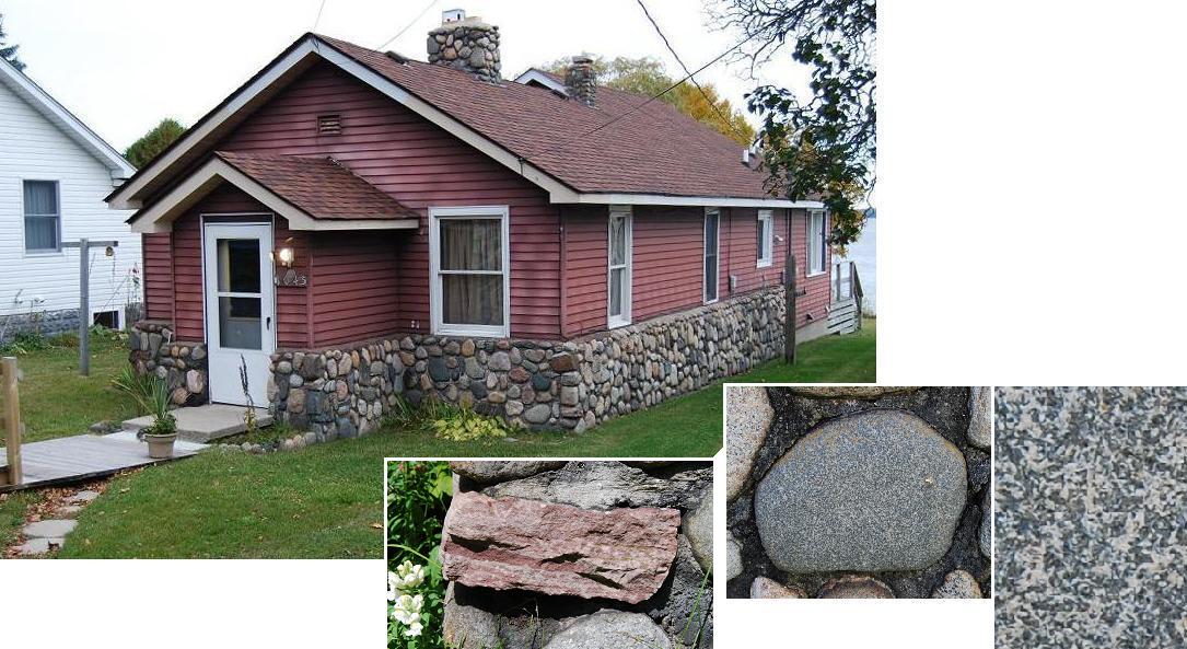
Summer cottageon Brevort Lake on
the north
side of the extension of White
Birch Road,which is also noted as Old Place Rd. on the road marker at
its junction with Brevort Lake
Rd. (Rte.
H57). This cottage
was built in 1936-1937 by Joseph Luepnitz.
Summer home on northwestern
Marquette
Island of "the
Snows" (Les
Cheneaux), near Hessel. This structure, which includes six
bedrooms, as well as the large central section, was built in 1917 for
Edward K.
Hardy.
John Stanholm, a Scandinavian immigrant, is thought to have been the
mason. Since 1941, it has been owned by former U.S. Senator
Prentiss M. Brown and his heirs.
Most of the stones are "limestone" rubble fragments --
i.e, only
a few "hard-rock"
cobbles are included. All of these stones are said to have come
from the
island and
nearby lake
bottom.
A
few parts of this structure are shown below the main
photograph: Left, A close-up that
shows the predominance of "limestone" rubble in the
masonry. Center, One of two fireplaces
that are in the large room, which extends end to end in the central
unit of the building. Right, One of two of the
decorative
walls with arched openings
that occur at the ends of the complex.
Similar
stones
have
other roles here and there on the rest of this property -- e.g.,
decorative and functional walls that are around the
tennis court and along pathways. A stone-faced
"blockhouse," "warehouse" and icehouse..., each of which are shown in
this album, are also on this property.
"Blockhouse" is the
name widely
applied to this building, which is near the northwestern end of
Marquette
Island. The designation is based on the
shape of the building, which was made to resemble that of military
blockhouses -- e.g., those on Mackinac Island. Most of its facing
stones are cobble-sized, and both "limestone" and "hard
rocks"
are
included. This building,
built as the "guest house" of the preceding Summer Home, was built
in or about 1917.
"Cabin" near the
eastern
shore of
Bois
Blanc Island. This building was built in 1934 as a log
cabin. The stone masonry was added in the 1960s. Most of
the stones
are
"hard-rocks" from nearby Lake Huron. Their variety,
especially so far as their shapes, is evident in the left
close-up, which
shows part of the
lower courses of the chimney. The shapes and sizes of the stones
chosen for corners is exemplified by the the close-up on the
right.
Officers' Stone
Quarters at Fort
Mackinac,
Mackinac Island. This building, built in the 1780s,
is "The only building remaining from the British era and the only one
built entirely of limestone [--i.e., "limestone"]"
(Petersen, 1973,
p.30). Until
1876, it provided quarters for two
officers, including the fort commandant, and their families.
Bedrooms and parlors were on the upper floor; kitchens and dining rooms
were on the lower level. Even
though obscured by the paint, it is clear that a few well-rounded
boulders, most likely"hard-rock" stones transported into the region
by glacial ice, occur along with the predominant "limestone" --
notice, for example, the two stones near
the upper left corner of the close-up on the right. The
close-up on the
left shows the
dressed stones of the chimney.
Currently, the front part of the lower level of this
building is the fort Tea Room.
OTHER BUILDINGS & STRUCTURES
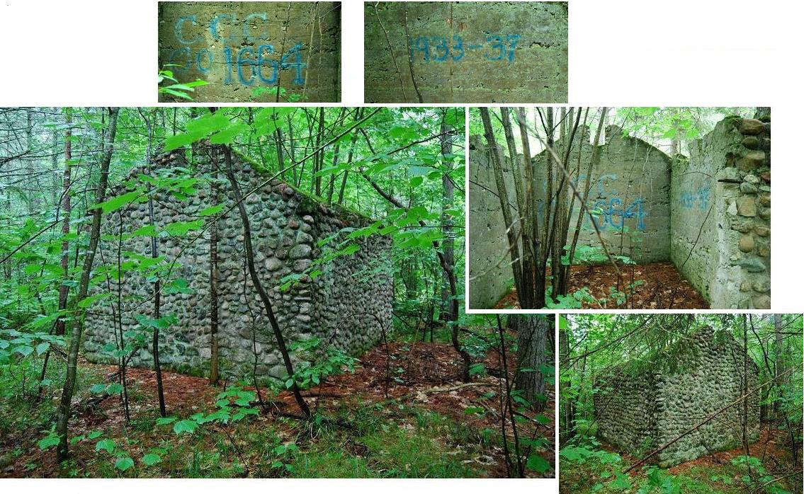
"Blast shack" is the
name
generally given for this fieldstone-faced structure, which is north of
Rte.
2, west of Brevort. The size -- ~ 14 x
12-feet, with
roof peak ~13 feet high -- along
with the
windowless sides, thickness of the walls and overall character of the
interior of this building
evince its use as a place
where explosives
were stored. Notice that with few exceptions the walls, other
than the corners, are faced by cobbles rather than boulders; I
suspect that this, as well as the thickness of the walls, was
considered an important safety measure for a building with this
function. In any
case, nearly all of the
stones consist of "hard rocks."
The
blue
paint, apparently added during a reunion
(1987?) of members
of the Civilian
Conservation Corps (CCC),
indicates that
the building dates to 1933-1937,
when CCC Company #1664
members were stationed nearby. This group referred
to themselves as the "Lost Legion" and to their barracks area as "Camp
Moran." For additional information about the CCC in the area, see
Heritage... (1998).
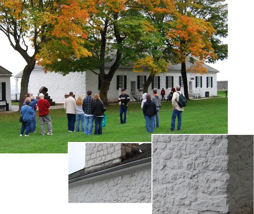
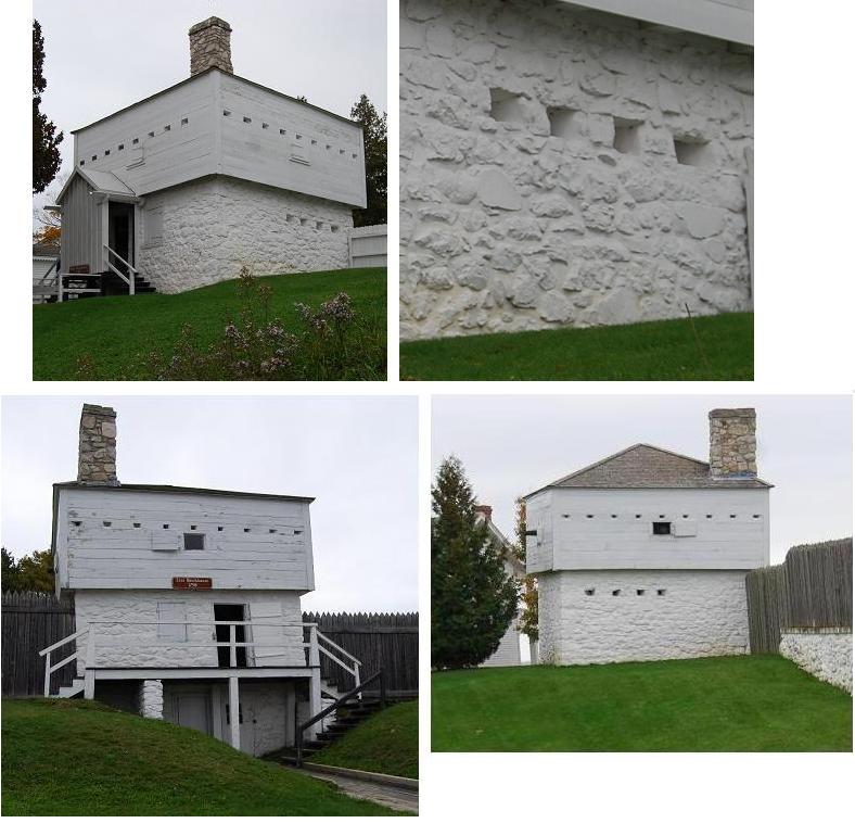
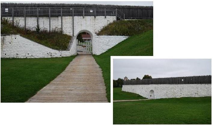
Fort Mackinac
Blockhouseson
Mackinac
Island. Three are present: One on the west, one on the
north and one on the east. The one on the west is said to be the
most
photographed building on the grounds of the fort. In this album,
the one on the north is shown in the two top photographs, and the one
on the east is in
the two lower photographs. These two
blockhouses are indicated to date from
1798.
The
upper right view gives an indication of
the diverse sizes and shapes of the constituent stones. The lower
left photograph shows the lower level of this blockhouse. Notice
also the makeup of the chimneys.
Like
the other stone structures at the fort, the stones of the lower
level(s) of the blockhouses are painted
white. On the basis of their shapes, sizes and surfaces most of
these stones appear to be "limestones" but a few
"hard-rock" stones appear also to have been included in each of these
structures.
Icehouse &
Woodshed on
Marquette
Island. This structure, with the enclosed part a former ice house
and the open part where wood was stored, is another of chiefly
stone-faced buildings included in the
complex that includes the Summer Home, "Warehouse" and
"Blockhouse" on
northwestern Marquette Island. It was apparently built during the same
general time that these buildings were built -- i.e., ~1917.
--&&&--
Kilns.
The
word structures, included
in the subheading for this section, applies in particular to the next
three
entries. None
of them is a building in
the true sense. The first one is known to have been a
lime kiln; the second one has been tentatively identified as a
lime kiln; the function of the third one is yet to be
determined.
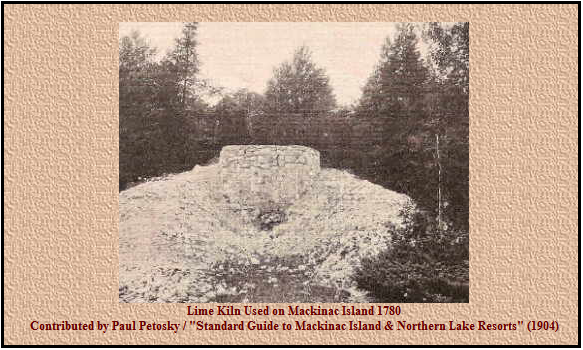
As
can be seen, this
stone structure on Mackinac Island is recorded as a "Lime Kiln" and is
said to date to 1780. It was
about a
quarter of a mile from
the fort, and the lime produced in the kiln is said to have been used
by
the soldiers in construction of the
fort (Petersen, 1973).
At
least some of the "lime kilns" of this area were used
to "burn"
dolostone rather than, or as well as, limestone. The product of
"burning" dolostone is CaO, MgO whereas that of "burning" limestone is
CaO;
both, however, were likely referred to as lime or burnt
lime at that time, as indeed they continue to be in many places
even
today. In any case, whatever the product was called, most of it
was apparently
used as mortar for stonework.
This
"structure" is on the lake
side of Rabbits Back Stack. Its remains consist largely of "limestones," many
of which
are
block-like though of various sizes and
overall shapes. Nearly all of the "blocks" have weathered
surfaces. The characteristic weathered surfaces
plus their overall shapes indicate that at least most of these "blocks"
represent rubble rather than building stones that were removed -- e.g.,
quarried -- from the nearby bedrock. The structure is
roughly
cylindrical with an inside diameter of about nine feet and a backside
height of
about eight feet. Trees around the structure indicate that it
is at
least 75 years old, and it seems likely that it dates back several
more years, perhaps to
the 1700s. Indeed, Eby (1928, p.36) describes it as one "of the
old
French lime kilns," which would date it as existing before the
mid-1700s.
The
shape of a grown over area a few feet away from this structure
indicates that a second similar structure was once there or at least
once in
the process of construction there. I wonder if it, in fact, if
either of these structures may
have been used to make charcoal rather than "lime."
These
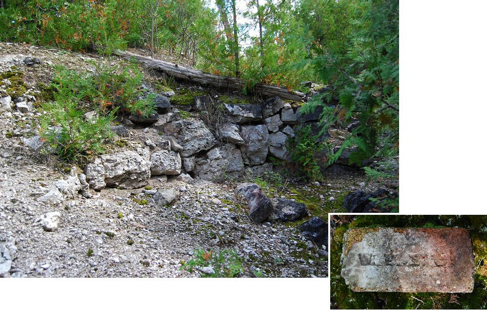
remains of a kiln are east of the former railroad track, south of
Kenneth. This kiln may be one of
"about seven" charcoal kilns that
were part
of the Martel Furnace Company venture of the 1880s (Kiwanis, 1957, p.82). I say "may
be" because
Luepnitz (1936?, p.10) reports, on the basis of his personal
observations, that the Martel Furnace Company's charcoal kilns were on
the William Pecta farm near Allenville. In any case, although
recorded as charcoal kilns, these kilns are widely referred to as lime
kilns
by nearby residents. The old brick, shown on the
lower right, was found near this kiln.
--&&&--
"Powder (dynamite) Magazine" on
the grounds of State Park,
Mackinac Island. This small, nearly square, stone building
consists of both
"limestone" and "hard-rock" stones. The walls
are approximately seven feet long, outside dimension.
It is not known for
sure when
this
building was made, but apparently "after the fort was abandoned (1895)
and probably between 1920-1940" (Phil Porter, p.c., 2010).
Perhaps it dates to the 1930s when the CCC was on the
island.
"Playhouse" on Avery Point in
Hessel
Bay. This building is thought to date back to at least the
1910s. It is part of a complex that includes a summer home, a
boathouse, a teepee-shaped whatever, and other structures. Although I
have only seen this building from a distance, and the photographs were
taken with a telephoto lens, it seems safe to say that the stones
very likely came from
nearby.
The
close-up, to
the right of the larger photograph, shows:
1.the relative abundance of dark-colored stones on the smaller chimney
and
2.the fact that stones of about the same size make up the individual
courses of
the wall.
The inset
close-up
shows the characteristics of the
corner of the building (entranceway?) to its left.
Root cellar. This former root
cellar, north
of Rte. 139, just
west of Cedarville,
is said to
have been built about 1910.
Nearly all of the stones are "limestone" rubble from relatively
nearby rock formations. Many of
the rubble fragments have been rounded -- some apparently only by
weathering, others more likely during stream transport or while they
were on the
lakeshore.
.
"Warehouse" is the
name one of
the long-time owners applies to this building on northwestern Marquette
Island.
Built in the late 1910s or early 1920s, its original use is not
known. Currently it is used as storage shed. Its facing consists
of rounded "limestone" rubble
and
"hard-rock" stones from the island and
nearby lakeshore. The building in the background shows the
chimneys of the fireplaces in the large gathering room of the
Summer
Home of this complex. PARTS of
BUILDINGS
St.
Ignace's LaSalle
High School and a few
residences within the area are faced
in part by
masonry that
features
fieldstones. These buildings, along with a few examples of
fieldstone-faced entranceways, foundations, porches, chimneys and other
residence-related uses are treated in this
section. The examples shown were chosen to indicate
the
variety of these features that occur. That is to
say, the list is not inclusive -- i.e., several
more of these
fieldstone-based parts of buildings occur within the area.
Partial
Facings. Although
these are
functional as siding, several are better characterized as
decorative.
LaSalle High
School is on
Portage Rd. in
St.
Ignace. Built in 1961-1962, this school was first used in the
Fall
of
1962. Split-face
fieldstones serve as “decorative” portions
of the two walls that are
shown. G. Arntzen & Co. of Escanaba is recorded as the
architect(s). Jack
Riness,
formerly of East
Lake, is
said to have been responsible for the stone
masonry.
Nearly
all of
the fieldstones
of these walls are "hard rocks."
Each has been split and its split-face is exhibited. Although the
stones are said
to
have come from a nearby sand and gravel pit, the identity of a few of
them indicates that at least they were brought into the area from
elsewhere.
Residence with fieldstone trim
on the
east side
of Huron St., St. Ignace. This masonry, which exposes the natural
surfaces of rounded fieldstones, is said to date back to
the 1950s.
Ned Fenlon is said to have been responsible for the masonry, but it is
unclear as to whether this means that he had it done as owner,
which
he was, or if he may also have done the masonry.
Notice
also the
fieldstone-faced chimneys. In addition, a
fieldstone wall, which is said to have been laid during the same time
period, is on the
street side of this house and originally extended southward along a
couple other lots.
The
small
photo on the bottom
right
is a close-up of part of the dolerite fieldstone to its left.
Residence with
fieldstone-faced section
on the
south side of Duke’s Rd. in Moran. Albert
Langstaff is said to have built the
house, including the masonry in 1949.
Both stones
with their natural surfaces and stones with their split-faces exposed
are
included. A few of the stones -- e.g., two jasper
puddingstone cobbles, which are above the doorway -- were brought into
the area from, I suspect, eastern Chippewa County (e.g., Drummond
Island) or perhaps Bois Blanc Island of Mackinac County.
Residence with
fieldstone-faced section,
near the end of E. Adolphus St. in Moran. The fieldstones that grace the front
of this
house are chiefly small boulders with their split-faces exposed. Several kinds
of igneous,
metamorphic and migmatitic rocks, which were glacially transported
southward from Canada, are included. Two particular
interesting ones are shown.
House with stone
trim, on the bluff
east of East Lake. This stone masonry veneer is beside the main
entrance. It is
included here as an example of the masonry of
Jack Riness, one of the area's well-known masons. Riness
and his wife, who was from
near Tupelo, Mississippi, and their children lived in this house.
It is said that they were the
first family to have lived the "year around" at East Lake. Nearly
all of the stones of this façade are sandstone, albeit a rather
diverse
variety. Some of these stones
appear possibly to represent split-faces of fieldstones. It is
not known,
however, whether all, none or only some of them are really parts of
fieldstones rather than of quarried
and dressed bedrock.
In any case,
split-faces, some of which appear to represent former bedding planes,
are exposed. The mortar joints are those widely
referred to as beaded (see close-up).
Summer place on Marquette Island
of Les
Cheneaux Islands, near Cedarville, with its lower level faced by split
stones and the flat sides of rubble. The masonry of this summer
home, widely referred to as the Armour House, was done during
the 1930s. All of these photographs were taken with telephoto
lens while I was in a boat -- i.e., I was unable to see this masonry
and the stones included otherwise. The "close-ups" show details
of the stonework over a doorway, a window and a double window.
Each consists of stones that were dressed to produce the desired
pattern. Notice that "red" stones -- naturally red? -- are
near the centers of the arches
over each of the double windows.
Vacation Home on the
north side of Worth Rd., near Brevort. Part of the front
of this home is
faced by split-faced
fieldstones.
A
nearby storage building has a similarly fieldstone-faced lower
section,
part of which can be seen in the background on the right side
of the main photograph.
The current owners, John and Madlyn Masten, had this place built in 1993.
A fieldstone-faced
panel behind
a stove within the dwelling and an
outside
fieldstone fireplace
on this lot are
shown elsewhere in this album. On
the basis of their compositions, virtually all of the constituent
stones
could
have been picked up from glacial and glacio-fluvial deposits within
the nearby area. However, John, who did the masonry, told me that he
brought
these stones from near their home in the Ludington area.
Residence on Adolphus
St., Moran. This house, including the masonry around the main
entrance and of the chimney, is said to have
been built by John Lipnitz in the 1930s. "Limestone" rubble, "hard-rock"
stones
and even brick are included in the entranceway.
Foundations and
Porches. Masonry that
includes
fieldstones constitutes many foundations and the facings of several
porches within the area. The following are examples.
Foundation of St. Ignatius
Loyola Catholic Church in
St.
Ignace. The cornerstone of this church, established in 1670, is
dated 1904 (see lower middle photo). The sections of the
current building's foundation include
several noteworthy features: Virtually all of the stones are
"hard-rock" stones, probably from nearby glacial and glaciofluvial
desposits. Most are boulders; a few are
cobbles; all
have split-face surfaces exposed. Some sections of the
foundation
have rather uncommon mixtures of the different sized
stones. A bead, originally painted red, but now faded in most
places, occurs
on top
of the mortar of most of the surfaces. Where present, the
diameter of the bead is markedly less than the exposed widths of the
mortar. Although the bead
typically surrounds the individual stones, here and there it extends
around two adjacent stones, and in a few
places is atop a stone's exposed surface (see photo on upper
right). One area of the stone masonry of
this foundation was placed more recently -- i.e., about
25 years ago (Ollie
Boynton, p.c., 20100). It consists of similar "hard-rock" stones,
but the mortar joints have no bead (see photo on lower right).
Foundation
plus of
a cabin-home on the eastern side of the
Mackinac Trail north of Garden Hill Creek. Built in 1940, the
fieldstone part of this structure is approximately 4½
feet thick
at its base and
gradually decreases upward to a little less that 2 feet thick
at its top.
Most of
the fieldstones are "hard
rocks" that were glacially
transported into this area from Canada. A few, however, are
slightly rounded rubble fragments derived from fairly nearby
sedimentary rock formations -- note, in
particular, the
light gray ones near the corner.
Foundation and "cellar" wall of summer home
on east side of Bois Blanc Island. The facing of this foundation
consists of stones from the surrounding area, including the shore of
Lake
Huron.
John
Engel, the owner, did the masonry in 2002. His stonework
includes
several "images" -- e.g., the "faces" of two guardians one on each side
of
the "cellar" door, which is foreshortened in the lower right
photograph.
The three stones shown on the right side of the main photograph are
relatively uncommon in stone
structures within the
Mackinac County part of the Straits area.
Foundation-like
arrangement
of
stones around
the base of a trailer in the trailer park on Grove St.,
Cedarville. These stones, most of which were collected nearby,
have been added by Derinda and Mike Mann, the owners,
within the last two or so
years. The close-up, lower right, shows the corner of this faux
foundation that is behind the wooden pole in the main photograph.
The two stones that
resemble an animal track and a human skull, which are two favorites of
the owners, are on
display
elsewhere on their plot. Stones like these, which resemble other
objects, are
called
mimetoliths
-- see
Dietrich, 2010a.
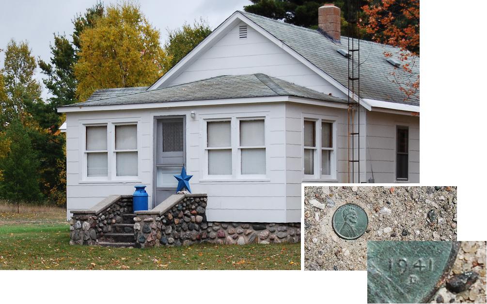
Foundation
&
"stoop" of
a house
on the eastern side of
Schoolhouse Rd., Brevort. The milk
can
is on the area referred to as a stoop -- at least that is the name
usually applied to these "small porches" in my native
northern
New York.
The mortar around the stones of the foundation and the stoop and the
makeup of the slabs that constitute the "railing" appear to be
identical concrete -- i.e., their cement and aggregate are
indistinguishable, at least macroscopically. This is mentioned
because the penny, dated 1941, is
embedded in the concrete near the bottom of the sloping "railing" on
the left. This, of course, does not mean that the masonry dates
to 1941, although it may; it means only that the concrete of the
railing was made some time after this 1941 penny was in
circulation.
I suspect, however, that the penny was "new" when the concrete was
made, and therefore is another example of
how the
masonry of
some fieldstone structures can be dated, at least tentatively (for
other examples,
see Dietrich, 2010). In any case, this general date agrees
with
the fact that the original
residents are
said to have lived in this house when
the "man of the house" returned from WWII. So, the masonry
appears to date to the early or mid 1940s.
Porchon the north
side of Bertrand Street in
St.
Ignace. The base of this porch, the supports for its posts and
the risers of its steps are faced with fieldstones, most of
which
have "hard rock" compositions. The
stone on the left, an
amphibolite, is part of the stone work. The stone in the center,
an amygdaloidal volcanic rock, was loose beside the porch and may or
may not have once been part of the masonry; the photograph to its
right is a close-up that shows the character of the amygdules.
Porch on
the
west side of the west branch of Martin Road, which extends north of
Rte.
2 west of St. Ignace. This is the only fieldstone
masonry face that I have ever seen painted black.
No one seems to know why this was done.
Porch with
split-faced stones -- see close-up -- and Chimney with the natural surfaces of
its stones exposed. This is cabin No. 1 of the Loreli group at
Hessel. It is said to have been built in the the late
1920s. John Stanholm, a Scandinavian immigrant, is credited with
the masonry.
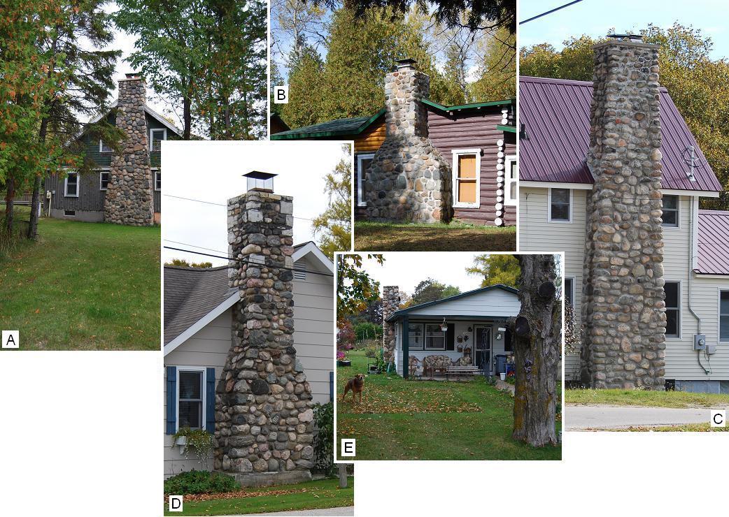
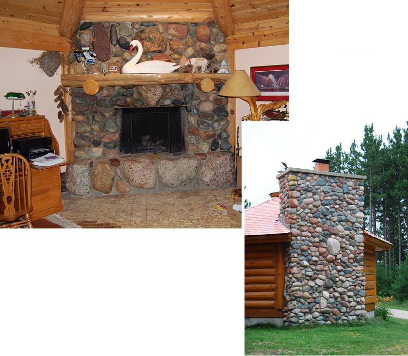
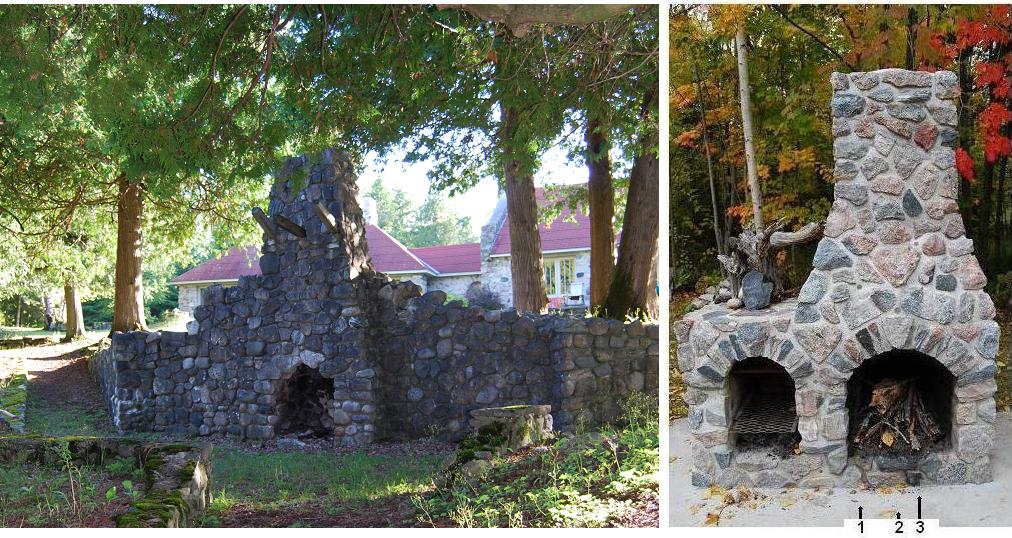
Chimneys
and two additional uses.One of the most
common uses of
fieldstones within the area was, and continues to be, to face chimneys,
especially those for fireplaces. There are literally scores of
these chimneys. Those shown here are examples that are indicative of
the fact that each is quite unique. Additional
chimneys can be seen in some of the other photographs.
A
story about Edwin W. Windberg, a former well-known mason in the area,
warrants
recording here: While building
a stone chimney, Windberg was told that the man for whom he was working
was "poor pay." Upon hearing this,
Windberg, unbeknown to the man, placed a
pane of glass horizontally across the opening of the chimney before
adding higher courses and "completing" the masonry. The
following Fall, the man, who, as a matter of fact, had not paid for the
work,
called Windberg and told him the chimney was
no good, that it did not draw, ... .
Windberg is said to have responded, "If you pay me, I
will come out there,
and guarantee that when I leave the chimney will work." The man
then paid for the work. Windberg put up a ladder, climbed to
the top of the chimney, dropped a boulder into
the opening, thus breaking the glass, whereupon the chimney drew, etc.
The
additional uses are also
shown as examples of ways
fieldstones have been used in masonry within the area.
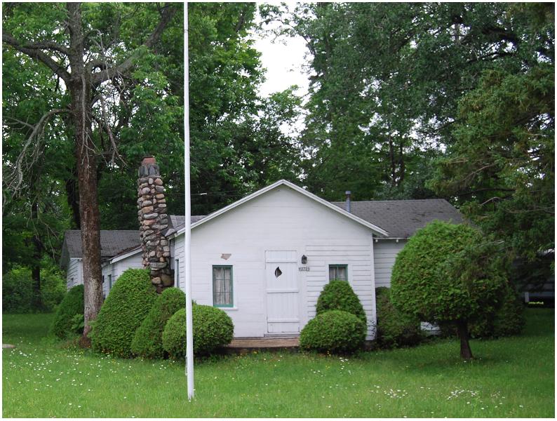
Chimneys.
A, on Boulevard Drive, St.
Ignace: The "log house" precursor of this house was moved from
its original location when the "Big Mac" bridge was being
built. The chimney was added later, probably during the 1950s. B, on
a cabin at Ponchartrain Shores.
C, on a
house on
the north
side of
Dickerson Street, St. Ignace. D, on
the house
on the southwestern
corner of
Casey and Huron streets, St. Ignace. E, on
the west side of Huron St., next-door to "D," in St.
Ignace.
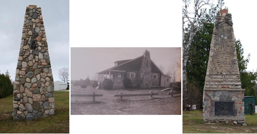
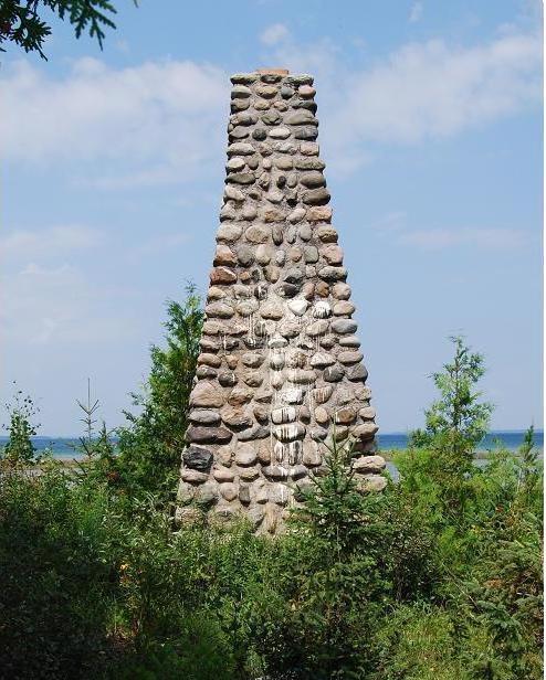
"Leaning
Chimney of Brevort
Lake."Not the "Leaning
Tower of
Pisa" -- But, while viewing this chimney -- and, by the way, the flag
pole is vertical! -- one wonders such things as: Was
it built
that way?
Has any budding
scientist dropped objects of different weights from its top? ...?
-- Unfortunately, I
have been
unable to
find anyone who
could answer my questions about this chimney. Consequently, it
seems only safe
to say that it consists largely of small boulders and cobbles that were
probably collected from nearby deposits of glacial
and/or
glacio-fluvial transported rocks that were once part of Canada's
bedrock. See some
later learned information
about this chimney in theAdditions and
Revisions:PartsofBuildings
Chimney section at the beginning of this file.
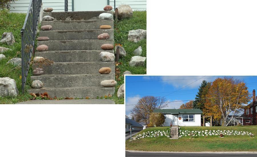
Stairs &
Pedestals. Most uses that I
consider
"additional ..." are rare, and some are probably singular, at least
within this area. Two are illustrated by the above photographs. Left, Fieldstones plus mortar
comprise both the steps
and risers of these stairs to the back door of this house, which is on
the north
side of Rockview Rd., east of Three-Mile Rd. Right, Fieldstone and mortar
pedestals serve as the bases for the "log"
posts at the
corners of the covered back entrance to this same
house.
Indoor
Fireplaces. Examples
of
fieldstone-faced fireplaces and a
fireproof backing for a stove are
included in this
subsection. Several additional fieldstone-faced fireplaces
are in
residences of the area. On the other hand, the fire-proof panel
that is shown is one of only two that I have seen within
the area.
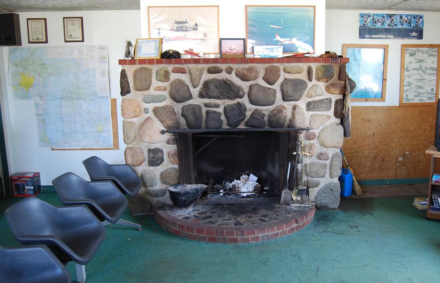
Fireplace in the former
Mackinac County
Airport Terminal at St. Ignace. The mortar to stone ratio is
greater for this fireplace than virtually all of the others I have seen
within the
area.
Fireplace in a summer home in
Hessel. This fireplace, built in 1979 by Edwin Winberg, is
faced by split-face chiefly "hard-rock" boulders from
the nearby area. The current heating unit, however, is
gas-fueled. As
shown by the photograph on the lower right, a
similarly
faced area, which is outside of the fireplace, constitutes a sizeable
part of the southwestward-facing
side of this home.
Fireplace and chimney of
another summer
home
in Hessel. A second,
back-to-back fireplace is in the
master bedroom. This side includes several remarkable stones, a few of
which have
special connections for the owners. Three examples are
shown: Top, a stone,
which exhibits
differential
erosion, that was collected on Beaver Island by one of the
owner's
mother;
Center,
a cobble, which includes a fault, that was collected by her
father at
Whitefish Point (this one was wetted when photographed); Bottom,
a quartzite boulder from
Poor Mountain, Virginia, which is near her birthplace.
Most of the
rest of the stones came from near Moran and from old dock cribs around
the
Les Cheneaux islands. This fireplace was built in the early
1990s; Eldon and Edwin Winberg were the masons.
Fireplace in a residence on
the north
side of Rockview Rd. east of three-mile Rd. Left, The stones of this
fireplace,
other than the relatively large boulders of "jasper puddingstone" -- e.g., the
central, roughly
heart-shaped stone
below the mantel and four of the large stones in the front part of the
hearth -- came from nearby. This "puddingstone" -- from the
Lorrain Formation of Ontario -- is well known and
widely sought for such use. Although this rock is not known to
occur as fieldstones within
the glacial deposits of Upper Peninsula part of this county, it does
occur on Bois Blanc. These boulders, however, came from
Drummond Island, which is part of Chippewa County. The masonry is said
to have
been done in
2002. Right, The outside chimney for
this
fireplace. The large central boulder of this chimney is also
"puddingstone" from
the Lorrain Formation.
Indoor
fireplace in
a summer home on the east
side of
Bois Blanc Island. This fireplace, with split-face stones,
replaced
the brick fireplace that was originally in this residence. The
stone
work was done by
Jim Vosper, the present owner, and his father in 1933. The stones
came from the shore of Lake Huron.
"Fireproof"
backing for
the stove in the vacation home north of Worth Rd, north of Brevort.
Split
faces of the stones are displayed. Several different igneous and
metamorphic rocks that were glacially transported southward into
Michigan from Canada during the last "Ice Age" are included.
The masonry was done
by John Masten.
Former
Fireplace-chimneys. A few
fireplace-chimneys that
stand
alone are within the area --
i.e., they are no longer connected to their original building or any
inhabitable remains of that original dwelling. Some of these are
relatively large and consequently serve as prominent
"landmarks." In any case, these structures, which are quite
different from outdoor
fireplaces, provide strong support for the lesson that was to be
learned from the old Fairy Tale about the big bad wolf, who
"huffed and puffed ..." on the three little pigs' houses that were
built
of straw, sticks and stones (or bricks) -- a tale that was often told
to children of my generation. That is to say, these structures make it
quite obvious that
structures made of stones and
mortar outlast structures made of such things
as wood.
This
one dates from the 18th or early
19th century (See text on plaque).
Both
of the old photographs are said to show the remains of the chimney
that was part of Shabwaway's cabin, which was located near "Chimney
Point" on eastern Marquette Island. The photograph on the left, slightly
cropped, is attributed to Myron E. Wheeler
(Grover, 1911, Frontispiece);
the photograph on the
right is from the collection in the Les
Cheneaux Historical
Museum at Cedarville. These two photographs seem not
to be of the same structure, even if they are considered to have been
taken at different times as the structure was deteriorating. An
alternative
explanation can be hypothesized on the basis of the following
"facts": "this chimney was, until some five years
ago [i.e., ~1906], in the condition shown
[i.e., as shown in the left photograph] ...
when some campers thoughtlessly tore down the upper part of it.
... [Subsequently, a person] replaced it as carefully as possible, with
the same stones thus torn down, and upon the same foundation," (op.
cit., p.64-65) which would be the structure shown in the right
photograph. However, this explanation seems unlikely, at least to
me,
when one considers the differences between the two structures.
So, . . . ? In any
case, the makeup of both structures appears to have included
both "hard-rock"
stones and "limestone"
rubble
like that now along the nearby
lakeshore.
Unfortunately, no stones that seem to represent the former chimney
remain at the location. The
brass plaque on the marker, which consists of fieldstones and concrete,
is located at the former site of the chimney.
This
fireplace and its chimney was
part of the former clubhouse of
the St. Ignace Golf Course. The
clubhouse and stone fire-place-chimney are said to
have been built in the late 1920s and razed in
1998. Fortunately, this chimney has been
preserved and remains in fine shape. Left, the out-of-doors part
of
chimney. Center, the chimney and
clubhouse in 1953 (photo
courtesy of Ollie Boynton). Right, the
indoor side of the structure. Notice the features, bottom to top, that
can are
exhibited: the
fireplace, which is faced
by split-face surfaces of
fieldstones; the section that was covered by the top four logs
of the wall and the siding of the gable part of the clubhouse;
[and] the
top several
inches
that include stones that were exposed to the "elements" above the peak
of the roof.
This
fireplace and its chimney
served a
cabin that was formerly northwest of the intersection of Church St. and
Duke's
Rd. in
Moran. The sequence of
features, bottom to top, is essentially the same as that described for
the preceding fireplace-chimney. The
round
hole above the fireplace was for the stovepipe of the cook (and
heating) stove within the cabin.The cabin and chimney were built
by Frank Becker
in 1934. The black and white photographs show the
cabin when the
chimney was being built and soon after it was completed (black
and white photos, courtesy of Kay
Matelski).
Two more:
Left, This
one is on the lake side
of White Birch Rd., near Brevort Lake. Originally, it was the
source of heat for a homestead that is said to
have dated back to at
least the early 1900s. Today, it sometimes is used as an
outdoor fireplace. This fireplace, unlike the two preceding
ones, is faced by the
natural, rounded surfaces of its constituent fieldstones. Right, This two-flue
chimney
is near the east bank of Pine River, north of Rte. 134. Built in
the 1950s, it served as the flue for a fireplace and for two other
heating units. It was at the so-to-speak second generation
"Sofie's Tavern." The
original Sofie's Tavern, which was located about a mile to the west, on
the
western side
of the Mackinac Trail, was
reputed to be a favorite
"watering hole" for steel workers who worked on the Mackinac
Bridge. Part of an advertisement
in Before the Bridge(Kiwanis
...,
1957, p. 221), states:
"See
the wheels [two, I am told] that spun the 41,000 miles of wire on
the Mackinac Bridge."-- apparently a tie between the workers and the
tavern. The successor to the
original
tavern, of which the
photographed chimney was a part, became a popular stopping
place for deer hunters. The
former
roof line, which slants downward to the right, is readily
apparent. This second tavern was destroyed by fire "about 30
years ago."
This
one is on Rabbits
Back Peak Peninsula, near
the shore of Lake Huron. The area of
white
defaced stones is not the work of gulls; it is white paint,
apparently
the work of vandals. According to a long-term resident of
the area: This chimney and an adjoining cabin were built in
the early
1950s; John
Englehardt and his family
lived in the cabin for several years; [and] as of the late 1980s,
the main building
had deteriorated and "was no more."
This
fireplace-chimney
that featured the natural faces of fieldstones was part of a residence
that was
located on
the hillside north of State Street (Rte. 75B) east of downtown St.
Ignace. The house was torn down in the
late
1970s. In any case, the
continued
existence of even this part of the fireplace provides another good
example of the durability of stone masonry. In fact, the stone
part of this fireplace has even outlasted the part of the associated
chimney that was
brick. I suspect, however, that at least some of those bricks may
have been recovered for reuse elsewhere. The topography,
perhaps due to
the former existence of a cellar, and overgrowth made it extremely
difficult for us to get these two photographs. (The khaki
cloth in the lower left is the knee of my slacks; I was in a
rather precarious position while taking the photographs; Charlie
Brown was holding the trees and bushes so some of the stones would
show.)
Parts
of the buildings that once were served by these last two
fireplace-chimney examples also remain. Nonetheless, they also
provide examples of how structures that consist of stones and mortar
outlast most of the other common building materials, in these cases,
predominantly wood. Left, This
fireplace(?)-chimney
was part of a small residence west of the northern end of Martin
Rd. The positions of the old logs of the wall right up to its peak are
evident. The stones of the structure are virtually all
"hard rocks" and consist largely of boulders near the bottom, which is
overgrown but can be seen on the outdoors side.
Cobbles, including some rather small ones are higher up -- see, for
example, those that are above the former peak. The makeup of the
fireplace, if indeed there was one, is unknown; it appeared
unwise
to try to remove the logs etc. that now cover it to make this
determination. It is believed
that
this residence dated back to at least the 1930s. The fact that it
had electricity indicates that it probably did not fall to nonuse until
after the
mid-1900s. Right,This fireplace-chimney was part of a
cabin near the shore of Lake Michigan near Gros Cap. The
stones used to make it were loose on the nearby
shore. They consist of diverse "limestones"
derived from relatively
nearby
formations. The masonry
of
this structure,
which was done by Joe Moody, dates to the late
1960s.
~~<<+>>~~
II.
OTHER USES
The
diverse
uses
of fieldstones for things other than the facings and
other parts
of
buildings is amazing. More than a few of the uses have
made me
marvel
at (wo)man’s
ingenuity.
These uses
range from strictly
functional to
merely decorative, and some of them serve both
purposes rather well. So far as this area
The
fieldstone population within much of this area
differs
markedly from that of other areas where I have made similar
studies. The main difference relates to the predominance of loose
fragments of "limestone" in
much of
the area. "Hard-rock" fieldstones are,
however, predominant in a few parts of the area. And,
fieldstones of both of these kinds of rocks occur together here and
there. However,
despite the overall predominance of "limestone"
rubble
in much of the area, most of the uses
treated
in the following, as well as in the preceding, parts of this album
involve
"hard-rock"
fieldstones. This may lead some readers to think
that my coverage in this album has been overly influenced on the basis
of my earlier experiences and
my predilections as a "hard-rock" geologist. So be it.
Actually, it is quite clear that
"hard-rock" stones were preferred by most of the people who have used
fieldstones within the area. This preference
is
easily explained: Virtually all "hard-rock"
fieldstones have more
attractive colors and textures and are more
durable
than "limestone"
rubble.
LANDSCAPE ACCENTS
The
most widespread
use of
fieldstones within the county is to modify the appearances of
landscapes. Althought this use appears to be concentrated in some areas
-- e.g., Hessel and parts of Cedarville and St. Ignace -- it occurs
sporadically throughout the whole area. The stones that are used
range
in size
from pebbles to large boulders. As already mentioned, both
"limestone" rubble
and divese "hard-rock" stones are used. In some
places, only one or
the other of these two kinds of stones are used; in other places,
mixtures of both have been used.
In
viewing the diverse uses of this genre, one wonders how
many of the stones that are being used were originally moved merely
to
get
them out
of the way -- e.g., so they would no longer trip someone or ruin
the blades of some farm tool or the land owner's lawn mower.
However, it is known that
some
of these stones have been purchased, either as individual stones,
usually
boulders, or in numbers and transported over relatively long distances
to be put in their current locations. Indeed, fieldstones,
especially
"hard-rock" cobbles and boulders, are widely marketed as
"designer stones."
Fieldstones
as landscape accents range from single boulders,
placed as "highlights," to large numbers of fieldstones of similar or
diverse sizes, shapes and ompositions,that have been
arranged around such things as flower beds, shrubbery, flagpoles,
mailboxes and along driveways.
The examples included in this volume provide only a sampling of the
uses within the area.
Several other examples could serve the purpose equally well.
Indeed, a large volume, much larger and more colorful than this one,
could be compiled about these uses within this area!
Boulders
serve as landscape
accents at
many places.
These are great to see, especially for those who, like me, have never
seen a
rock that doesn’t make them stop to look at it and to think -- think
about
its origin, its subsequent history, how it got to where it is, etc.,
etc. In addition, some of us also tend to consider each boulder
that is, or is part of, a landscape accent on
the basis of its
aesthetics and how it fits its location: Why was this one
chosen? What does it say to those see it?
Is its
presence
inviting? foreboding?
.
.
. ? . . . ?
In
addition, my
thoughts about these boulders’ current settings have led me to
wonder
what motivated the person to put them where they are: Did
(s)he just like the looks of the particular boulder and want it
nearby?
Was it an
ego thing -- i.e., was the property owner’s primary desire to have, for
example,
the largest
boulder in his or her neighborhood? Was it chosen because of
some
historical attachment (s)he had to the boulder or perhaps to the
place
from which it came? -- One can speculate almost
endlessly. In any
case, I
have mentally applied
one or more adjectives to
almost all
of these boulders on the bais of how I see them so far as fitting into
their
surrounding area. Those adjectives, with connotations that
range from highly positive to
rather negative, expressed my thoughts as I viewed each of the
hundreds of boulder accents within the area. Several
of the
adjectives
that came to mind were preceded by "too," "very," or
"quite." The following, listed alphabetically, are examples:
Appalling,
appealing, appropriate, atrocious, attractive, awful, bizarre, bold,
charming, choice, delightful, disgusting, excessive, extravagant,
fitting, flamboyant, gaudy,
harmonious, hideous, horrendous, horrible, interesting, intriguing,
lovely,
monstrous, obtrusive, ostentatious, outrageous, pleasing, preposterous,
pretentious, repulsive, revolting, showy, suitable, tasteful,
terrible, terrific, ugly,
weird, ... And, I should add that a few led me only to
think, or say to myself, "Wow!" Some viewers of the
same boulders would, I feel sure, use other
descriptive terms. Consequently, it seems imprudent
for me to characterize any of those shown in this album by any of these
terms. One
method by which a few of the accent boulders were
moved to their current
locations was "new" to me and thus seems to warrant
recording: Janet Werkheiser, upon seeing some boulders with
characteristics that
she liked under relatively
shallow water on the bottom of Lake Huron, loaded them onto two
surfboards that were
lashed together, and pulled the boards plus the boulders to
shore.
From there, the boulders could be moved by commonly used methods and
put where
she wanted them. Though quite different, Janet's removing
boulders from beneath the water reminded me of the contrasting method
used to remove boulders from the lake bottom during the
construction of Martin Reef Lighthouse (see Sellman, 1995, p.
29).
Boulder entities.
A, This large boulder, on Graham
St.,
Saint Ignace,
is a granitic gneiss that includes small folds. It was moved to
this location from a pit
that was formerly
in the area behind LaSalle High School. B,
This similarly
sized boulder,
on Brevort Lake Rd, is a dolerite. It was moved to this location
from the field behind the house.
Boulder plus. This
boulder and several other landscapes that feature fieldstones are are
on Mackinac
Island. Here, the other features include grass. lichen, moss,
small and large trees (including their roots), slabs of rock and a
man-made sign -- though granted, nary a flower. To me, these
constituents provide an eclectic
overview of the use of fieldstones along with the other elements that
characterize the diverse kinds of landscaping on Mackinac
Island.
Boulders in
groups occur here and there within
the area. In some places, they are close
together; in other places, they are in so-to-speak
patterns.
Those
shown here are south of the Keg & Anvil shop on Schoolhouse
Rd. in Brevort. They are part of a complex in which the owners
plan
to have one or more tepees and a large "peace pipe" as its main
features. (The tepee-to-be in the main photograph, with its Norway
spruce beams now covered, is 18 feet across (Ayala, 2010)). These
great, at least geologically speaking, boulders came from a small
island near the mouth of Pte. Aux Chenes
River. The one on the lower left is a gneiss; the one on
the lower right is a migmatite transected by a
granitic dikelet; the one on the upper right exhibits the effects
of differential weathering and erosion.
Boulders atop
boulders. Stones
have been placed atop stones in several places. Some of them are
certainly meant to be landscape accents -- e.g., above, right;
others become such, at
least in the broad sense, even though they certainly were not meant to
be --
e.g.,
above, left. Th Some of them were
apparently so-placed just to get them out of the way -- e.g.,
above, left. Others were apparently put where they are to prove
that
boulders of their sizes could be so-balanced, stay that way and become
"showpieces" -- e.g., above, right. Left,
This example appears to
be an example of just getting the stones on top out of the way.
It is on the south side of Duke's
Rd., west of the Immaculate Conception
Catholic Cemetery, Moran. Right,
This, to me, is an example of a landscape "showpiece" that proves that
boulders of these sizes can be so placed. The pair are west of
Wartella Rd., north of Brevort Lake Rd. (H57), east of
Moran.
Other
occurrences of stones atop boulders (etc.) within the area seem
to indicate quite different activities and objectives. Those
shown in the two following photographs and those shown under the
subheading "Cairn- and Inukshuk-like stacks of stones," near the end of
the album, are
examples. Only one group of these, the cairn-like
stacks near
Brevort Lake, appears to have been
conceived as landscape accents. But, each certainly changes the
appearance of the landscape where it occurs.
This group is at
Ponchartrain
Shores.
The boulder base is much smaller than the two preceding ones -- the
surrounding grass and leaves and the
pen knife provide a scale. The four stones atop
this boulder are intriguing: When
I saw
them, I
could not help but wonder "What little hand or hands put them
here?
Why were they put in their relative positions? . . . ?"
The base of this group
is a
relatively large boulder-sized fragment of the breccia formation
that constitutes the "stacks" of this area. The stones atop it
are typical of the "limestone" fragments that occur nearby. This
group was on the southwestern shore of Mackinac Island on September
29th, 2010. The balancing of the relatively large stone, on the
right, is rather
remarkable. The close-up is included to direct attention to two
mimetoliths: 1.Notice how the upper
left part of the balanced stone resembles a person -- parted hair,
eyes, etc. -- peering over something (a là Wilson of the TV
sitcom Home Improvement).
[and] 2.Notice how the front of the boulder-sized base resembles
an animal -- a sheep, a shaggy dog, whatever -- including its
eye.
Boulders that
welcome.
These boulders and painted wagon wheels are on the west side of
Wartella Rd. near its northern end. To me, their grouping must
have said to anyone who approached this lane "Welcome, Come In."
Today's quite different directive seems but another "sign of the times."
Boulders
as deterrents
to traffic, be it foot or vehicle, are widespread within the
area.
Several of them are
near the borders of the restricted areas. Some
of
them actually serve as obstructions. Others are better described
as "signs" to be respected. Many of these boulders serve
also as "Landscape Accents." The group shown in the two top
photographs, which are beside the
parking lot for the Ferry on Bois Blanc Island, seem to emphasize the No Parking sign.
No Trespassing !
! !
These boulders were
placed
to keep vehicles from parking or encroaching on the owner's property,
which is on
both sides of Boulevard
Drive, St. Ignace. The boulder with two sides shown -- upper
center and right -- is an especially interesting migmatite, my favorite
group of rocks. The black subplanar mass that transects the rock
is a metamorphosed igneous dikelet.
Driveway "dots". Small
boulders
and cobbles along a driveway east of East Lake
Rd., just north of
Charles Moran Rd.
Driveway "dots". Larger
boulders along a
driveway off Gros Cap Rd., northeast of St.
Ignace.
"Dots"
such as
these, though neat and tidy, are upsetting to geologists, especially
petrologists. This is true because the stones are painted. Be the
colors patriotic -- i.e., red, white and blue -- or green, yellow,
purple, ... black or brown, painting of stones, whatever their use,
conceals their identities and other features, each of which is a
"document" that may be important to deciphering some part of
our geological history. In addition, the paint blots out
the
stones' natural beauty!
"Lines" of juxtaposed
stones. These
fieldstones,
chiefly boulders, abut one another and consequently really serve to
obstruct
vehicles from going from the driveway onto the grass. They are
near the lakefront
in eastern Cedarville.
"Lines"
Left,
These small boulders
surround
a billet for a trailer at the trailer park on Grove St., Cedarville. Right,
These small boulders and
cobbles
delineate a walkway within the trailer park.
Waterfalls and
cascade beside
the 12th
hole of the Grand Hotel's Woods golf course. Some of the
combinations of fieldstones and water, particularly moving water, are
for me the crème de la crème so far as use of fieldstones
as landscape accents. Consequently, this is my favorite on
Mackinac Island.
Waterfalls and
small streams
are
highlights on this property in the Woodland subdivisionnear Cedarville.
They serve both to complement and, in my opinion, to compliment the
diversity of the
stones, rocks and plants of the area -- or vice versa, depending upon
the viewer's point of view.
Stones,
which
range in
size from pebbles to boulders and include some large blocks of rubble,
have
several diverse roles on this property. Most of these stones are
from
nearby. However, several rocks from distant localities
-- e.g., the flagstones on some of the paths that are from Montana --
are also
included.
"Dry
waterfall" northwest of the
junction of
Church Rd. with Brevort Lake Rd. (H57). These stones were placed
to resemble a waterfall by Robert Wirt. All of the stones were
on the surrounding grounds.
Patio-walkway. This
patio-walkway is on the east side of Bois Blanc Island. The stones were
selected and placed by John Engel. In placing the stones, he
incorporated some
interesting arrangements -- e.g., the "point" of the black,
spearhead-shaped dolerite stone and the "streaks" of the gneiss, which
are shown on the
close-up, are oriented so they point
toward
the north.
"Total
Landscape". This
designation has been used
elsewhere for collections of stones, especially boulders, that have
been placed in certain ways that make them appear to dominate a
sizeable
area. The grouping of fieldstones in the main photograph seems
to fit this
definition. It is the focus of the "turn around" area at the end
of the drive to the home of Nick and Laural LaChapelle, who created the
arrangement in 2009-2010. The lower right photograph shows
another area where
the LaChapelles have put some more of their favorite fieldstones as the
main components of a "flower garden." And, when I took the
photographs, they were working on yet another area that will be
fieldstone based.
With
two or three exceptions, all of the
boulders in these displays came from within a mile of their
residence. The boulders included, which are chiefly
igneous and metamorphic rocks and migmatites, constitute a veritable
museum collection of the diverse rocks carried into this area during
the last "Ice Age" glaciation.
Cobbles.
Cobbles
are, in essence, small boulders. In this area, as elsewhere, most
fieldstones of cobble size are used in groups. In several of
these groups, virtuallyall of the fieldstones are of cobble size;
in several others, fieldstones of cobbles, particularly large ones, and
boulders, typically relatively small ones, occur together. The
examples shown under this subheading in this Volume consist largely or
wholly of cobbles.
Walkway on
Bois Blanc
Island that
extends from a summer home to the beach
area. Cobbles, nearly all of which are "hard-rock" stones are
along the edges. The walkway itself consists largely of
relatively flat "limestone." This walkway
was made
by the owner, Jim
Vosper.
Walkway
& steps.
Left, This stone and mortar
walkway is between the yard and driveway
at the house northwest of the junction of
Duke's and Martin roads, Moran. Some
of the exposed surfaces are natural; others are
split-faces. The narrow area covered by concrete with a coarse
aggregate, which is between the walkway and the driveway,
serves not
only to eliminate a short step that could lead to one's tripping but
also as a surface where mud that may have accumulated on one's footwear
while
working in the lawn or garden could be easily removed -- i.e., "scraped
off." The
masonry was done by George Litzner.
Right,
These stones, with no
mortar, provide steps from the lawn area down to an area
that is at near
the lake level of Brevort Lake. The constituent stones might
well be considered "stepping
stones." Notice
also the roughly
circular
group of stones that constitute a stone planter and the smaller
group of stones around the young pine tree. These arrangements
were
created by Barb Palmer; they are at the same
locality as her Cairn-like stacks.
Stones
on steps. These large cobbles
and small
boulders are on steps that
are on the north side of
Portage
St. in St.
Ignace. Although this use of stones is hardly a Landscape Accent
as such, as can seen in the smaller scale photograph, this use does
tie into the adjacent use of Landscape Accent stones on the adjacent
slope. Notice that the nearly all of the
stones on the steps are well-rounded stones of diverse compositions
whereas most of those on the adjacent bank are rubble.
Planters
& stone-bordered flower beds. Many fieldstone
based
structures that are referred to as planters are indistinguishable from
flowerbeds surrounded by stones. The terms that are enclosed in
quotation marks here are the designations applied
by the owner or someone else who talked to me about the feature.
A, This retaining wall, which
extends from the ground upward to
the level of the top of the house's foundation, is beside the house on the northwestern corner of the
junction of
Duke's Rd. with Martin Rd.
in
Moran. It dates to 1950 and 1951. Two kinds of stones are
included: those that
exhibit their natural surfaces and those that have their split-faces
exposed. George Litzner was the
mason; his wife Patricia "finished" the mortar joints.
B,
Two views of a
two-level "planter" on
the corner of
Casey and
Huron streets in St. Ignace.
C,
A
planting
area beside Gros Cap Rd. -- Hundreds, perhaps thousands, of flower beds
surrounded by stones occur within the area. Each could claim this
spot in this volume. This is one that I drive by each time I go
west to Rte.
2; I do not know who designed it, when it was created, where
these stones came from or who owns it, but I like
it!
D, An elongate "planter" with
its
right (road) side higher than its left. This planter, actually
with boulders, rather than pebbles, predominant, is on
the western side of Church Rd., just north of Brevort Lake Rd. (H57). The
boulders were dug up from the surrounding grounds and
put in place
by Bob Wirt in 2010.
"Frame"
or
"display frame"
are the
names frequently applied to groups of stones that surround things
other than flowerbeds and
shrubbery. Some of these frames are merely juxtaposed stones
like those that around flowerbeds. Others constitute veritable
walls, albeit
typically low ones. In any case, the
main purpose of fieldstone "frames" appears to be to exhibit and,
in some cases, protect the things they surround. The
diversity of things that are displayed in this way is
mind-boggling. Although many of the
"frames" within
this area consist wholly or largely of stones that were picked up
nearby,
others include stones from sand
pits
and from beach areas, especially those along Lake Superior.
"Frame"
of loose fieldstones around the base of a flagpole. It is north
of
LaVake Rd. near its dead end.
Left, frame,
which is a low wet-laid wall around an old hand-held tiller, on
a lawn north of Pte.
LaBarbe
Rd. Center, frame,
which is a dry-laid
wall, around part of an area that includes some rather diverse man-made
items
as
well as trees and bushes, on the north side of Charles
Moran Rd., west of Rte. 123. Right,
stones
around a bird bath -- not for the bird shown! -- north of Brevort
Lake Rd.
(H57),
west of Moran.
Left, part
of an old harrow, with
the stones as its background as well as its "frame," along Portage
Rd. Right, stones around the lower part
of a
debarked, broken-off tree along with larger stones that more or less
surround an old, rusted drag-anchor comprise this display near the
junction of the east and west branches
of Martin Lake Rd.
A
one-boulder-high
"frame"
around
Moran's "Welcome" and plantings on the east
side of Rte. 123.
A
fieldstone "almost-'frame'" that sets off a mid-20th century
cedar-strip(?) sports
rowboat on a
lawn
north of Pte.
LaBarbe
Rd. The group of fieldstones include several diverse rocks --
both "hard rocks" and "limestones." Differential weathering
and/or erosion of some surfaces of the latter rocks is especially
evident.
"Wishing
wells" with
bases of stones occur
sporadically
throughout the area. In essence, these bases are circular,
freestanding walls, and virtually all of them are wet-laid. Most
of these "wells," including those with
windlasses, are only
decorative
-- i.e., they are not directly related to a source of water. This one,
which is beside
Shore Drive in Evergreen Shores, is an
exception. Although it is now only decorative, it was formerly
associated with a flowing
spring/well, which is now virtually dry. The fieldstones of
this structure were
taken from a dry well that was formerly on the same
property.
Alan
Werkheiser, the current owner, did the masonry in 1971 or '72.
Pillars
that
consist of fieldstones
occur here and there within the area. They are particularly common on
the "built-up" part of Mackinac Island. Three examples are shown.
Left, Light "post" near Grand
Hotel, Mackinac Island. Center,
"Name post" for a
summer home on Pte. LaBarbe Rd.
This marker, dated as September 1942, was made by George Yates, then
the owner.
The stones were collected nearby. The small boulder on the
top is a
salmon-pink granitic rock that is transected by a black
basalt dikelet. The small stones spelling "Youngstown"
and
"Ohio" are pebbles that have been
painted black. Right,
Light
"post" on the north
side
of Brevort Lake Rd. (H57) east of Rte. 123.
Roxanne
Powers-Tallman included stones from several sources including fields,
gravel pits
and Lakes Huron, Michigan and Superior to create this structure.
This
quasi-lighthouse
"pillar" is beside the entrance to a
trailer park on
Grove St. in
Cedarville. The approximately 12-feet high
fieldstone masonry
base,
the outside of which consists largely of mortar with the included
fieldstones as decorative elements, was built in 1984.
~~<<+>>~~
WALLS When I
think about the walls within this general area, I recall the
information
recorded1 about stone structures
beneath Lake Huron. I
wonder if any of the accumulations of fieldstones treated in
this album were
also made soon after the glacial ice of the last "Ice Age" no longer
covered
the area. See, for example, the
roughly donut-shaped "pile of stones," which is the last entry in Part
I, BUILDINGS: Subsection OTHER BUILDINGS & STRUCTURES.
_____________________
1. According to O'Shea and Meadows (e.g.,
2009), the structures beneath Lake Huron include stone piles, which
appear to have been used to attract caribou, and
drive lanes. The lanes are described as long rows of rocks
(walls?)
that were meant to
channel the caribou into ambushes. These, as well as other stone
structures, occur on the now
submerged Alpena-Amberley ridge, which extends some
100 miles between
Presque Isle, Michigan and Point Clark,
Ontario. This ridge was
apparently dry land between about 9,900 and 7,500 years ago.
_____________________
~~<<+>>~~
Stone
"fence" west
of Church Rd., Moran. Fence-line
accumulations of
fieldstones are
frequently
referred to as stone fences or stone rows. Although some people
refer to them as walls, they are not walls per se. Most
of these
"fences"
consist of stones removed from their adjacent field(s) to
"clear the land."
--&&&--
True
walls. The
stones of true walls are chosen and placed by the individuals who make
them. The stones may be wet-laid or dry-laid -- i.e.,
with or without mortar. These walls are often
characterized
as freestanding or retaining: Freestanding walls are those that
extend upward from the ground with
their sides and tops open to the air; retaining walls are those
that have only one side, plus or minus their tops, open to the
air.
Fieldstone walls of each of these kinds occur here and there throughout
the
area, and are especially common in Hessel and central
Cedarsville. A few examples of these diverse kinds of walls
that are within
this area are shown in
the
following photographs.
Dry-laid
walls. Relatively
low
dry-laid stone
walls mark the edges of driveways at many
places. Left,
freestanding
wall beside a
circular drive north of
Kenneth
Rd. in
Hiawatha National Forest. Right, retaining
walls that keep the
grass-covered soil from creeping to lower levels at Pte. Aux Chenes.
Dry-laid
wall at Hessel.
This
freestanding wall
consists of
diverse "hard-rock" and sedimentary rock boulders, angular to slightly
modified rubble, fragments of rock apparently derived from of nearby
bedrock,
..., ... and even concrete blocks. It is said that this wall
was "squared up"
and the concrete blocks
were
added relatively recemtly.
Culvert
headers. Dry-laid
retaining walls are often
named on the basis of their
special roles and/or locations. These two are on the north
side of Charles Moran
Rd., west of Rte.
123. The photograph
on the
right also
includes a stone-surrounded planting area.
Wet-laid walls
define the perimeter of Fort
Mackinac on
Mackinac
Island. Retaining, freestanding and hybrid walls are
present. The
earliest walls date to 1779-1781; later
walls, primarily on the north side of the fort, date from circa
1800.
Parts of some of the walls are eight feet thick. Although
the constituent stones are painted white, their shapes and other
characteristics indicate them to be a mixture of "limestone" and
"hard-rock" boulders.
History is said to indicate that a large percentage of the
"limestone" was quarried (P. Porter, p.c., 2010), but I suspect several
of the "limestone" components represent pieces of rubble from
the surrounding area including the shore and off-shore areas of Lake
Huron.
The walls are said to
have been white from soon after the time they were built (op. cit.,
2010). Whitewash
was likely used for the first and several
later coatings. That being the case, the apparent lack of
such a coating in a
photograph, dated 1865 (Petersen, 1973, p.27, bottom), would seem to
indicate that it was taken when much
of the whitewash had been removed by rain etc. Currently they are
painted white.
Over
the
years, the stone walls and other parts of the fort have been
repaired. For example, about ten years ago, the walls underwent a
restoration that "involved repointing 16,250 square feet
of façade ... [and,] when it was not possible to rely solely on
historic techniques, all modern materials were concealed. For
example, a system of modern steel reinforcements was embedded several
feet into concrete and hidden under a shell that precisely matched a
19th century walkway's original appearance"
(Smithgroup...n.d.).
The
area
of the fort also includes several other fieldstone-faced
structures. Along with the Officers' Stone Quarters and the
ground-level stories of the three blockhouses, which are treated
elsewhere in this album, stones are also major constituents of such
things as the
"frames" and bases for some of the cannons and the foundations of
several structures as well as the bastions and ramparts which are
incorporated with the perimeter walls.
The black and white
photographs, both taken between circa 1885-189, are reproduced here courtesy of the
Mackinac State Historic Parks. The
photos taken in
2010 show part of two walls including a sally port.
Wet-laid
wall near
"Chimney
Point," Marquette Island. This wall, which was built beside a
former pond that also had sporadic, marginal terraced sides, apparently
dates to the early 1900s and perhaps to the 1800s. The view on
the lower right shows the pond side of the wall. The top of the
dry land side is somewhat rounded whereas that of the pond side is not.
Wet-laid walls of
more recent times.
Upper, This
curved
retaining wall is northwest
of the junction of Duke's and Martin
roads in
Moran. It consists of
split-faced
stones. George Litzner, a well-driller and then resident of the
house,
fashioned
the wall during the
early 1950s. Lower, This
freestanding
wall, which exhibits the natural surfaces of its fieldstones, is part
of a discontinuous wall on
the
east side of Huron St. in
St. Ignace.
It is said to have been built by Ned Fenlon during the 1950s.
Three
of the constituent building blocks of one of the "posts" of this wall
are
slag (i.e., the glassy residue of smelting of iron ore) -- see the
bluish
one in the lower left photograph. Another
completely different slag is at the bottom of the nearby wall.
The stones in this lower left photograph are indicative of the
diversity of the
kinds
of stones that are
included in this wall and its posts. Actually, however, most of
the wall consists of well-rounded "hard-rock" fieldstones.
Wet-laid wall
along the
drive
to the residence that is beyond the end of the west
branch of Martin
Road. This wet-laid retaining wall, said to have been built in
the 1930s, is the
longest wall associated with a single residence that I have found
within
the area.
The
top photograph shows a large
portion of the wall and the former house, which may be the one that was
listed on the tax roles of the mid 1920s. In any case, the house
is known to have been
there by the mid 1930s, and is said to have been built for Dr. Kirk
Stewart. It and the nearby barn and other outbuildings were
widely referred to as Kirkwood. The house included three
fieldstone
chimneys, one of which is shown in the photograph
(courtesy C.
Cullip). This
house was destroyed by fire in 2009. The chimneys survived the fire but
were not incorporated in the house that has subsequently been built on
the site.
The
two photographs in the middle show parts of the wall as it appears
today. They were taken within a ten-minute period with the
same camera
setting.
The two fieldstones shown at the bottom of this group were found on the
property. Both are "hard-rocks." The one on the left
exhibits some percussion marks, probably formed when this basalt was
hit by another stone during transit. The one on the right is a
metamorphosed sandstone -- i.e., a quartzite.
Wing
walls occur
at both
approaches to this
bridge where the Mackinac Trail crosses Carp River.
The bridge, listed on the National Register as of December 17th, 1999,
was built in 1920. The wing walls, also called "cobblestone
retaining
walls" (MichiganGov...2001-2010),
were
added during the 1929-1930 biennium (ibid.).
The presence of the USCGS benchmark, dated 1934, which is
embedded in the
concrete of the base upon which the railing of the
bridge is mounted,
has led to questions about some of the just-mentioned
dates. It should not, in my opinion. As can be seen in the
photograph on the lower left, the
concrete around the benchmark is not of the same batch as the
concrete of this part of structure; it appears to have been added
to fill hole
made for the concrete base upon which the benchmark was placed.
This, of course, means that the benchmark was added after the bridge was made, probably
in 1934 as indicated. In any case, these parts of this bridge
were demolished, unfortunately (in my opinion), in the early fall of
2010.
Most of
the cobblestones and small boulders of these walls are "hard rock" --
i.e., igneous, metamorphic and
migmatitic
rocks. The stones of the top course were split, and those
along
each edge were
dressed to give them at least two surfaces at nearly
right angles to each other. A few of the stones have fallen out
of
the mortar
(see close-up).
The Carp
River, by the way,
was apparently named on the basis of its going over a nearby escarpment,
rather than on the basis of the identity of its fish population (P.M. Brown,
Jr.,
p.c., 2010).
Walls
in cemeteries. Left,
This group of small
boulders certainly does not constitute
a wall per se. It is
more akin to the
previously described frames. My sensitivities lead to its being
included here along with the other walls in cemeteries. It is in
Grace Brethren
Cemetery, which is east of 27-Mile Rd., about one and half miles east
of
Ozark. Right,
This
low, wet-laid stone
wall, only part of which is shown, is
around a burial plot in the Gros Cap
Cemetery northeast of Rte. 2, northwest of St. Ignace.
See also the next photograph.
This
more elaborate
wet-laid wall is around a family burial plot in the
Brevort Township Cemetery.
Walls
featuring fieldstones
are widespread, especially in the residential areas of Mackinac
Island. They also are a prominent part of Fort Mackinac
and surround part
of St. Ann's Cemetery. This, of course, is what one would expect
because of the topography of the southern part of the island where
most of the residences, the fort and the cemetery are located.
Several diverse kinds of
walls are are
present. Indeed, those of just about any description
that one can imagine occur. Many of them are best
characterized as hybrids on the basis of their constituent stones
and/or their structures. The following are only examples. A. Dry-laid
retaining wall
that consists of boulders. B. Wet-laid freestanding
wall made up largely of rounded rubble. C. Wet-laid
retaining wall
made up of rounded rubble with its end-posts consisting of dressed,
"squared," blocks. Notice also the top course of this wall, which
consists of breccia with
its rough edges (etc.) exposed. This reminds me of the walls that
occur around, for example, some haciendas in Central America --
i.e., the walls that are topped with embedded pieces of broken glass
with their sharp edges protruding upwards, apparently to keep intruders
from climbing over them. D. Wet-laid
retaining wall,
the boulders of which include many diverse "hard-rocks."
E.
Apparently
one of the
oldest walls
on the island?! F.
An
entrance and adjacent
walls around St. Ann's Cemetery. Both are wet-laid and consist
largely of rubble, some of which has been dressed. The total length of
fieldstone walls at this cemetery appears to constitue the longest
fieldstone wall in the area.
Walls galore: G.
Chiefly
dry-laid walls. H.
Chiefly
wet-laid walls.
~~<<+>>~~
MISCELLANEOUS
USES
Only
a few fairly
common "miscellaneous
uses" of
fieldstones within this area are illustrated
here. Additional
"miscellaneous
uses," are treated briefly in Appendix
B.
Shore
Protection and Docks. Shore
protection and
docs are extremely
important in this area.
Both of these uses are common along some of the inland lakes as well as
along Lakes Michigan
and Huron.
Boulder
piling is
a widespread form of shore
protection. Three places where boulders and/or quarried blocks
have been piled to provide such protection serve as examples of this
kind of shore protection within this area.
Upper Left, along Lake Huron
just
north of the Indian Village in St.
Ignace; Upper Right,
along the southern shore of Brevort Lake. Below, quarried blocks of
dolostone along a concave bank of the Brevort River near one of the
bridges on Dam Rd.
Gabion wall along
the shore of
Brevort
Lake near
its outlet
into Brevort River. The
top photographs (courtesy
of USDA Forest Service) were taken after
its installation in 1966 (John
Franzen, p.c., 2010).
Notice that another gabion-constituted structure was placed
near the base
of this wall, on its lake side;
its remains
are now below lake level, covered with sediment.
As can be seen in the close-up of the two lower photographs, which were
taken in 2010,
the wire -- albeit galvanized and of greater
diameter than, for example, typical chicken wire -- has a relatively
fresh appearance. The fact that it
is only rusted near lake level is rather
remarkable considering the
climate of the area and the fact that the gabions have been here for
almost a half century.
The
placement of
this "wall," near the control dam at the
outlet of Brevort Lake into the Brevort River, was so-to-speak dictated
because this
section the shoreline witnesses more so-to-speak flowing water than the
rest of the
lake, especially when the lake
is relatively high and outflow into the river is greater than
normal. Indeed, if this part
of the shoreline were not so-protected, it would be particularly
subject to
erosion. Consequently,
I
tend to think of this wall as the area's best wall by a
damsite.
Breakwater, off-shore,
Hessel. The fieldstones of this
breakwater
are said to have come from a former crib dock.
Pond
side east of
Black Point Rd., north of Duke's Rd. The stones along this "duck
pond" merely define the shape of the
pond -- i.e., they are hardly needed for
shore-line protection. During the 1980s, Ervin Rose put
these fieldstones around this area after loose mantle was removed for
use as fill, and the area filled
with
groundwater. The stones came from nearby fields.
This
is but one of several
remains of fieldstone docks within
the
county. It is on
the southeastern side of Brevort Lake near Brevort Lake Rd.
(H57).
These two
crib docks are
at Hessel. The close-up shows the structure and relations between the
stones and timbers.
Fire
Circles and Outdoor Fireplaces. Five examples of what amount to
several scores of fire
circles within the
area are shown in this album. Each of them
includes dolostone rubble and
“hard rock”
fieldstones.
On the contrary, outdoor fireplaces are relatively rare. This may
reflect, at least in part, the fact that the usual roles of these
fireplaces had have been taken over by semi-permanent fire circles and
portable barbecues.
Left, This
relatively
simple, one-stone-high, fire circle is in Hiawatha National Forest,
west
of Search Bay. Right, This
more
complex
fire-circle, in that it is more than one stone high, is at Ponchartrain
Shores.
Large fire
circle, with surrounding benches and sawed-off tree trunks for
people to sit on,
is on the west side of
School House Rd., north of Worth Rd. When
I saw this
setup, I
recalled sitting around such fires and listening to and telling all
sorts of tales. I had to wonder what stories had been told and
what other
activities may have occurred around this circle.
These
two fire circles differ
from the preceding ones in that their fieldstones are held together by
mortar. Both are
near the shore of Brevort Lake. The seating around the one
on the left differs markedly from that around most
of
the fire circles within the area.
Outdoor fireplaces
are relatively sparse within the
area. Those shown exhibit rather different features. Left, This fireplace (~ 12 ft. high)
is on northwestern Marquette Island in
the complex that features the Summer Home, "Blockhouse," etc.
The constituent stones were picked up from the island or along its
shore.
Its construction predates that of the fireplace on the right by about
80 years. Right, This
fireplace
(~ 7 ½
ft. high)
is on the lot of a vacation
home on Worth Rd. John
Matsen, the owner and mason, built
it in 1994. The split-faced stones were brought to this area from
near
Ludington, even though similar stones occur nearby. Three
coins are included in the mortar: Upper left (straight up from
1), a "Big Mac" Bridge
token; Lower center (... up from 2), a
Kewadin Casino (Sault Ste. Marie, Canada) token; Upper right
(... up from 3), a
Sacajawea U.S. dollar. Notice also the black rock on
the top of the left-side unit; it was dressed to resemble
the shape of
Michigan's Lower Peninsula.
This
outdoor fireplace, with its idyllic setting, is northeast of Pte.
LaBarbe
Rd. It was built in the 1920s by Lloyd Obeshaw. The
"trees" surrounding it are pruned lilacs that are progeny of a really
large lilac, the
trunk of which is farther back and left of the fireplace.
This
fireplace is east of East Lake Rd., in the East Lake
community. It consists largely of dressed stones, at least some
of which
appear to have been
fieldstones. The masonry is attributed to Jack
Riness, former occupant of the nearby house, a section of which is
faced by similar sandstone stones and shown elsewhere in this album.
Decorative
items that feature stones,
most of
which are pebbles or small cobbles, have been made by a few
artists/crafts(wo)men residences of the area.
Mabel
Pechta (d),
formerly of Moran (see
McKevitt, 2008),
covered things, such as
vases, baby's shoes, plates and
tables, with small
stones. She
attached the stones with
Elmer's glue and then sprayed them with a
clear acrylic to bring out
their colors and heighten their lusters. Plates with the names of the
owners spelled out with white pebbles and surrounded by black pebbles
were one of her specialties. Mabel put the pebbles on this
table in the early summer of 2010, when she was 98 years old. Although pebbles
virtually
identical to those
she used occur sporadically
within the the county, most of those that she used came from
beaches along Lake Superior.
Roxanne
Powers-Tallman collected
the stones and made this 22 x 40-inch framed
hanging. The background is a sandy
grout; the stones'
brightnesses have been
enhanced
by an acrylic coating.
She created this piece as a memorial to her
father. Roxanne,
an avid collector of
stones, has many decorative pebbles, cobbles and boulders as accents
within her residence and on the surrounding
grounds. Most of the stones are from the
nearby
area and along the shores of Lakes Huron, Michigan
and Superior.
This interesting
piece, created by
Mallory Burkolder, is in front of a walkway between his house and a
storage shed that is west of Webb
Rd. south of Poglese
Rd. The stone (~15
inches in greatest dimension) is
a good example of the well-known jasper puddingstone of the Lorrain
Formation that
crops out sporadically in a belt that extends from north of Sault
Ste. Marie to near Bruce's Mine, Ontario. This stone was
collected
from glacial debris near Jonesville, Hillsdale County. The
stone has had a groove cut around its shortest
perimeter so the cable stays in place. In addition, it was
sandblasted to give it its relatively regular surface and coated with
polyurethane to enhance its luster. The metal frame is an ~4-inch
wide,
44-inch diameter wagon wheel. The circular frame can be rotated
on its vertical base; the stone rotates on its cable, sometimes
with only slight changes of the wind. This piece, with the fieldstone
as its focus, serves not only as a unique decorative addition to
Burkolder's
grounds, but also as a barometer. For details relating to the
latter "use," I
suggest that you contact Mallory.
Additional
items of this genre
include the following: Top,
Left, This
pebble-covered birdhouse (height ~5½ inches) is, as is true for
many like it, more decorative than functional. In fact,
this one
spends most of its
time on the mantel of its owners' fireplace. Right,
This pebble-sheathed mailbox
is
on Hill Island. Bottom, Left,
Relatively large
pebbles and/or small cobbles plus mortar are widely used to make such
things as this plant
pot (height ~1 ft.). The stones of this one, which is on a porch
on Brevort Lake Rd., are said to have
come from near Lake Superior
and the vicinity of Weidman in Isabella Co., Michigan. Right,
pebble-faced birdbath on the lawn of the fieldstone-faced
house in Cedarville.
This
"birdbath," more decorative than functional for any but
small birds to use individually, is on eastern Bois Blanc Island.
It was conceived and created by the Engels, whose patio and cottage
foundation are also shown in this album. It consists of two quite different
stones: The top one is a rubble fragment that apparently was rounded by
abrasion
to give it its concave top, as shown, while near the shore of Lake
Huron. The base is a "hard-rock"
boulder glacially transported into the area from Ontario; the
weathering and erosion responsible for the size, shape and surface
features of this boulder could have occurred prior to its being picked
up and
transported into this area by glacial ice and/or during its
transport by glacio-fluvial streams and/or as the result of later
erosion while it was along the lake shore.
Table
tops that are flat
stones occur here and there within the area. All of
those I have seen are decorative -- i.e., they
are so-to-speak landscape
accents -- as well
as functional.
The tops of these two tables are dolostone slabs
from nearby rubble. They are in the Woodland
subdivisionnear
Cedarville, on
the same property as the
waterfalls
and small stream also shown in this album.
"Rock
garden" at Evergreen
Shores.
Calling this pictured group
of fieldstones a rock garden, even enclosed in quotation marks,
is a
real
"stretch." It certainly
does not constitute what are usually called a rock gardens. It is
so-designated because that is what Janet Werkheiser, who conceived it,
collected the
stones for it and made it, calls it -- note the stone that is farthest
back on the right. Janet collected most
of these stones from
the nearby area, some from below the water, off the bottom of Lake
Huron.
This
stylized
replica of "Old Glory" is north of Chard Rd.
The constituent stones are NOT
fieldstones; rather, they are "manufactured stones" made to
resemble natural stones like those that occur in the adjacent
pit. The replica was made by the
son of
the pit owner. Fairly natural-appearing dolostone-like
"cobbles" comprise
the white stripes; surfaces that replicate split
faced stones fill the area where white
stars on a blue background are on real flags; bricks
constitute
the red stripes. This entry is included in this album with
"tongue in
cheek." My hope is that it will lead someone to make an "Old
Glory" using only natural fieldstones.
Monuments
and Markers. A few boulders within the area
have been engraved or bear plaques, most of which are "bronze," to
commemorate certain persons, events, or the like . Examples are shown
in the next few entries.
Two
other rocks in
St. Ignace that bear commemorative plaques are not
shown here. One, formerly on the west side of
Boulevard
Drive south of its junction with Rte. 2, but moved in 2010 to the
Bridgeview parking area east of Boulevard Drive, is "dedicated to"
David B
Steinman, designer of the Macnkinac Bridge. The
other, near
the
parking lot for the American
Legion Memorial Park on State Street, is "in memory"
of James Montcalm, a scuba diver in the area. The former
is a
squared block of relatively homogeneous dolostone; the latter is a
somewhat
modified, roughly diamond-shaped slab that consists of interlayered
fine and medium grained
calcite-bearing dolostone. Although the squared block may
have been part of a former fieldstone, I suspect it was not. On
the other hand, it seems likely that the slab of interlayered dolostone
is part of a
former fieldstone. Three
other plaque bearing boulders within the area, which are not
illustrated here, are in or near Cedarville. They are: 1.A
rounded dolostone boulder with an attached
bronze plaque that memorializes, "A man of vision," which is near the
waterfront in Cedarville; 2.A
nearby slab of dolostone with a plaque bearing a list of contributors
to the
Downtown Cedarville
Streetscape
Project of 2000; [and] 3.A
rounded
dolostone boulder with a bronze plaque at the "Scenic View" driveout
beside the swamp area on the
south side of
Rte. 134 between Hessel and Cedarville that has an attached bronze
plaque that includes a list of
individuals, including three memorials, and sponsors, and the
fact that the
lookout was a "A project [not dated] of Les Cheneaux advisory
(beautification) Committee."
Rogers monument is southwest of the junction
of Rte. 123 and the Mackinac Trail. How many of the constituent
stones of this
monument were fieldstones is unknown. Some
of the included stones were more likely mined -- e.g., the
copper-bearing
rock from Houghton County and the banded ironstone from Marquette
County.
Whatever
their
occurrence, at least
one of these stones came from each of the 15 counties of the Upper
Peninsula, and
all are said to have been "carefully selected and intended to represent
the
mineral and rocks products of that section of the state"
(Anon., 1929, p.5).
Unfortunately,
some of the mortar of this monument, especially on its north side is
crumbling. It should be replaced in the near future, not only to
preserve the integrity of the monument, but to be sure that none of the
stones
fall out and injure a
nearby observer.
Cemetery
monument and commemorative boulder: Left &
Center, An
engraved gneissic
boulder in
Lakeside Cemetery in southern St. Ignace.
Right, An engraved granite
commemorative boulder at the Les
Cheneaux Historical
Museum in Cedarville.
These
two boulders are at the
following locations:
A.
This
~5 ft. high granite
plaque-bearing boulder is in the Father Marquette
National Memorial
Park, northeast of Boulevard
Drive, St.
Ignace. B.
This ~5½ ft.
high boulder, is also
granite. Its nearly flat surface, upon which the
plaque is attached, appears to be a natural joint surface. It is
in a grassy
area near the entrance to the Arnold Line's passenger dock, St.
Ignace.
This ~5½
ft. high boulder, "C," is on the
lake side of the
parking lot at the American
Legion Memorial Park on State Street in downtown St. Ignace. It
is an
especially interesting rock: Much of it is
a granitic gneiss, but the composition of its right side, as shown,
indicates that
the overall rock unit from which it came is a migmatite. Mackinac
Island
is in the background of this photograph. The island's terraces,
which were
formed
when the precursor of Lake Huron had levels quite different from that
of the
present-day lake, are quite obvious. For an explanation of these
levels, see, for example, Hough (1958).
This, ~2½
ft. high
dolerite boulder, is northeast of
British Landing Rd., on Mackinac Island.
This
marker differs from the others. It consists of a boulder-size
dolostone fragment surrounded by rubble from one of the stacks or
similar occurrences of the Mackinac Breccia (see Landes, 1945).
The dolostone "boulder" appears to have been split to give the
relatively
flat surface upon which the plaque is mounted. The
surrounding rubble fragments are held together with mortar. The
statement on the plaque, which has aroused some controversy, has led
some people to call it the "Mac Plaque." The Missionary Bark
Chapel, a reconstruction thought to replicate the one built on the
island during the winter of 1670 by Jesuit Priest Claude Deblon, is on
the left in the background.
A few additional plaque-bearing boulder
occur on Mackinac Island.
To me, the most noteworthy, and prominent, is the one at Fort Mackinac
that
commemorates some some medical research performed at the fort by Dr.
William Beaumont. The plaque is mounted on a granitic rock atop
two blocks of the same rock, each of which was apparently shaped and
imported rather than made fashioned from local fieldstone(s).
Cairn-
and inukshuk-like stacks of stones. As mentioned
under the
subheading "Boulders atop boulders" in the section dealing with
LANDSCAPE ACCENTS,
stones have been placed atop
stones in several places within the area. With the exception of
the
first group, it appears that none of these was conceived as a landscape
accent per se.
In any case, all of
those shown here warrant special attention because of their general
forms.
These are four of several
cairn-like stacks of stones that
are on a lakeside lot on Luenitz
Ln. west of State Rte. H57. Barb Palmer, who made them, calls
them "Stone Castles." Most of the stones of these creations are
dolostone from
relatively nearby formations and were collected along the nearby shore
of Brevort Lake. Left,
The largest
stack, on the
left, includes
the most "hard-rock" stones of any of Barb's "castles". Right,
This one,
her first at this locality, is the only stack I have ever seen with a
tree
stump as
its base. It is unfortunate that rotting of this base will very
likely lead
to its not
standing
upright
as long as the ones on the ground.
These
two stacks of loose stones are close to the shore of Lake Huron near
the end of Hessel Point Rd. They
were created about
five years ago by Gretchen Lauer. All these stones,
including the boulder bases, are from nearby
formations. At the currently exposed level of the lake, the shape
of the boulder base of the "cairn" on the right, resembles that of a
reclining dog or perhaps a seal.
This
"stack" is north of
Kenneth Rd. It
is one of the two that are at the
east and west corners of a yard. Each is 5½ to 6
feet high and consists of dolostone rubble. As can be seen, the
top of this one roughly resembles a person's head topped by some sort
of
headwear. An
aside: Stones such as this one, which
resembles a person's head; the boulder base in the preceding pair
of photographs,
which
resembles a reclining
dog...; and the two shown in composite illustrating the
"Foundation-like ... trailer" entry are called mimetoliths.
For more information
and photographs of mimetoliths from several places, including elsewhere
in our planetary system, see Dietrich
(2010a).
A score or more of cairn-like
stacks of stones occur within the stony, near-shore area along the
southwestern side of
Mackinac
Island.
Unlike the preceding examples of cairn-like stacks of stones, which
were made by nearby residents, those of this area were apparently made
by
tourists. The
location of many of these cairn-like structures leads me to believe
that many of them will probably be short-lived. It seems likely
that they will be disrupted by either natural
or
human invasive activities -- e.g.,
the movement of ice, especially in the Spring, and the "people
traffic," especially during the tourist season(s). These four
were photographed on September 27th, 2010.
These
piles of loose rocks
are on the north side
of Cheeseman Rd. about ¼ mile north of Rte. 2. Although I
have
heard the piles referred to as cairns, I have found no evidence that
they were
erected as either memorials or markers for anyone or anything.
In addition, they do not look
like any cairns that
I have seen -- e.g.,
in the Scottish Highlands. From another standpoint, their
location does not
seem to be such that they
might would deter any vehicle, other than perhaps a snow-mobile, from
going
any
place its driver might logically want it to go; so, they seem not
to be
deterrents. Whatever they should be called and whatever their
purpose, each of them consists
largely of
pieces of rubble
from nearby sedimentary formations plus or minus a few boulders from
nearby apparently reworked glacial and/or glacio-fluvial deposits.
These inushuk-like stacks, which consist
largely of pieces of rubble
from the nearby shore area, were near the southwestern shore of
Mackinac Island, 27 September 2010. One of these
kinds of stacks has
also been photographed on one of the beach areas of Bois Blanc
Island;
however, while looking at
fieldstone structures on Bois Blanc, I found no one who knew
anything about either it or the other interesting displays that
included stones, of which photographs are on the internet (see "All
trees ...", 2008). As
mentioned for the
cairn-like stacks along this shore, I suspect that these stacks are
also ephemeral. I also suspect, however, that others will
take their
places
in within the area for all to see in the
future. An aside: I
have been told that inunnguaq,
rather than inushuk,
is the correct name for cairns that represent the
human figure.
Weights.
The use of fieldstones as
weights
is widespread.
Although most stones that have this role are used near where they
are picked up, a few kinds of "stone weights" are carried well away
from their original
locations. Two examples are the pebbles used as sinkers
by fisher(wo)men and the boulders used as anchors. Another
particular interesting use, similar to the one shown on the left,
below, is the placing of boulders atop garbage cans to keep the coons
from getting into them, ...
Two examples of
fieldstones used as weights that were picked up near
where they were used: Left &
Center,
The
small boulders atop the plastic
containers are
along a driveway on
the east side of East
Lake. These stones keep the
lightweight containers, which are protecting plants
from winter freezings and thawings, from blowing away. The
close-up is shown to emphasize the fact that stones with one
relatively flat surface are considered best for this
purpose. Right, This
use of boulders to stabilize a basketball backboard and
hoop is along Gros Cap
Rd.
~~<<+>>~~
"Wow"
& Worry Stone. As I
have noted
elsewhere, some fieldstones affect
people's mental states. Sight, sound or even touch may be the
activator(s). The two following photographs show a sight and
stone of this genre, at least for my mental state. The sound
aspect is represented by the "Waterfalls ..." photographs in the
LANDSCAPE ACCENTS section of this album. An
aside: Anyone who has
listened to the sounds that arise when water flows over or moves stones
has, I suspect, been affected. It happens to me wherever streams
flow
over stones, be it a cascade or waves flowing on and
off stone covered beaches. -- The different sounds that are made
range from quieting to disquieting. They are ever intriguing
and sometimes nearly hypnotic.
Buson, the famous Japanese haiku writer, alluded to these phenomena as
follows: "Winter storm, // The voice of rushing
waters // Is torn by the stones" (Translation courtesy of
Tadao Okazaki). Henry David Thoreau (1912, p.181),
wrote the following
about a
stream that he could cross by stepping from stone to stone: "Its
constant murmuring would quiet the passions of mankind
forever." Oscar Hammerstein II's lyrics in The
Sound of Music provide yet
another pertinent epigram: "To laugh like a brook when it trips
and falls over stones on its way ..."
Certainly
many of you have witnessed, thought about and cherished your
own or others' words about this role that stones have so far as in
giving
voices to water as it flows over them or the
voices that water gives the stones as it causes them to move over one
another.
WOW!!!
--- Another
aside: What about
these Fieldstones?
... Are they: In transport? For
sale? A
landscape accent? What? ------- I just do not
know and was unable to find out! BUT, to me, this
collection and setting seemed right
out of a story book. -- One
with thoughts
of the past, of today and of the future ! ! !
[Unfortunately,
this
“ancient”
wheelbarrow, laden with fieldstones, is no longer present where I first
saw it. Consequently, I really prize
this
photograph.]
Worry
Stone.
-- It's
mine. A
matter
of
tangential
interest:
An APPARATUS SIMILAR TO THOSE USED TO COLLECT PIECES of a ROCK NOT
USED AS a FIELDSTONE, though some people may consider the use of
compacted snow as building blocks of igloos to be an analogous use. This set of
tongs,
said to have been used by loggers, is one of four that are mounted on a
fence in Pte. Aux
Chenes. I have been told that similar tongs were also used
"in the early days" while harvesting ice from lakes in the area.
And, YES,
ice is a rock. It forms by solidification of a fluid
(water) just
as igneous rocks form by solidification of the fluid called magma,
which is widely referred to as lava when it is on the Earth's
surface. In addition, glacial ice -- so important because of its
role in transporting
virtually all of the "hard rock" stones into this area -- is a
so-to-speak metamorphic rock.
Large
quantities of ice were formerly taken from
the lakes for ice houses (See Kiwanis..., 1957, p.
95). Apparently,
before some of more modern methods were developed, tongs
with long handles
like those shown, were sometimes used to give the men near open water a
longer reach
to grab the ice blocks that were cut -- i.e., they could use such tongs
without having to lean over, and possibly falling into, the
frigid water. Also, such tongs were apparently sometimes used by
two-men
teams to lift the larger
blocks, which were sometimes harvested, onto the wagons that
transported them to the ice houses where they were stored.
~~<<+>>~~
III.
NEARBY FIELDSTONE USES OF SPECIAL INTEREST.
Several
uses of fieldstones in Michigan's Upper Peninsula that are outside of,
but within relatively short distances of, the
~25-mile circle, which was arbitrarily used to define the area covered
for this album, made
me want to extend the radius of the circle. Critical
considerations, however, precluded that. Nonetheless, a few of
those uses,
which I had
heard about or noticed in particular over the years, seem well worth
including in this volume. I hope that my doing this will whet the
imaginations of others and cause them to extend my coverage to
include more of the
uses of fieldstones within these "outlying" areas.
The
order
followed in presenting these occurrences extends clockwise
around the circumference of the
~25-mile radius circle starting near the north shore of Lake Michigan,
just east of Epoufette, Mackinac County. Examples are given from
Mackinac, Schoolcraft and Chippewa counties.
Stone studded panels in Monck's
Stone Bar, a widely known "watering hole" in
Epoufette, Mackinac County, from 1948 until the late 1970s. The
stones in the
panels were collected by the owner, Bill Monck, his wife Winnie,
and their son Bob
along Lake Superior where Muskallonge Lake State Park is now
located.
The three Moncks also made the panels.
Bill, a veteran of WWII,
is said to have always had his U.S. Navy sailor's hat on while tending
the bar.
(photo, an old postcard, courtesy of Bob Monck)
Hunting cabin &
companion
building in Hendricks
Township of Mackinac
County, on the
east side of the road between Epoufette and the Hiawatha Trail
(Rte. H40), east of Rexton.
The widely told story about the building on the right is
that the words "Porky
no chew," above its
doorway, were put there after this stone-faced
building was made to replace a former wooden building that was ruined
by porcupines. Both it and the adjacent building were built by
Clarence Brown, of the Fatsco Ant Poison Company, in the early
1950s. Unfortunately, the "Porky no
chew" building, with its concrete roof and partial iron lining, was
found
virtually impossible to live in during hot weather, especially for a
few days after it was first opened each year; it just didn't
breathe, and is said to have sweat profusely. Therefore, the
owner
made the building on the left,
which has, among other things, a wooden roof, and breathes. The
stones for both
buildings were collected from several places in the area between
the building site and Lake Superior. The intrusive breccia,
basaltic dike and folded gneiss shown left to right, respectively,
are three especially
interesting stones included among the fieldstones of these buildings.
House on
the west side of Rte.
77 in Germfask, Schoolcraft
County. This house was built in 1931 by Dan Decker, who was also
the
mason for the stonework of the former Catholic church, which was next
door to this
house.
The church, built in 1932, was destroyed by fire in 1972 (See Stone
Church...
2005).
The
close-up on the
left is part
of the nearly square post on
the left side of the concrete steps. The dark
gray, nearly black,
stone with the off-white spots is a porphyritic basalt. The two
close-ups at the
bottom show the patterns that are characteristic of the upper and lower
parts of
the south wall of the house, respectively.
The foundation, below the solid concrete layer, consists of
rectilinear-bounded blocks
that consist of rounded fieldstones and mortar. These blocks were
made in forms and
their tops, bottoms and sides were given rough surfaces. Production and
use of these blocks
allowed
the mason(s) to add more height during any given time than could have
been done by using the more common
procedure whereby
individual stones and mortar are added in courses.
House on the west side
of
Rte. H40, west of
Fibre, Chippewa County. This house was built in 1935 for Donner Dowd,
who specified
that he wanted the stones to stand out from the mortar; this
accounts for the
spacing. Jess
Riness, father of Jack Riness, was
the mason. The
included fieldstones, most of which came from near Lake Superior,
represent
virtually all of
the igneous, metamorphic and migmatitic rocks that occur in Canada,
north and northeast of this area.
Pillar-marker on the
grounds of
the
Point Iroquois Lighthouse
Station, which is on the shore of Lake Superior, just off 6-Mile Rd.,
which is called Lakeshore
Drive
near the lighthouse,
north of Brimley in
Chippewa County: Three sides of the pillar are
shown, along with an additional photograph of part of a wall on
the
property. Top,
Left, the pillar-marker and its general
setting;
Center, the side of the pillar that faces the
lighthouse;
Right,
one of the other sides of the pillar.
Bottom,
a close-up of part of the masonry wall that is around the lighthouse
area.
Stone
"fence" west of
Rte. 48, south of
Goetsville, Chippewa
County.No stone
fence of
the magnitude of those that are
widely referred to as such is known within the circular
area. This is one of a few that occur in this nearby area.
Residence on the lake side of Huron St.,
DeTour Village, Chippewa, County. This residence was built in
1924 for Thomas Luke Durocher, a local business man who was involved in
the salvage of ships and operated the "limestone" quarry on Drummond
Island. Most of the stones of this house are "hard-rock" cobbles from the shores of
Lake
Superior. Workers for Durocher are said to have hand-picked the
stones during "down periods" at the quarry. The size sorting of
these stones is remarkable; note especially how those of the
planters and risers of the steps are smaller than those of the main
parts of the building.
The stone wall, which is on the street side of this residence, has an
overall length of ~250 feet. Gateways and a garage break its
continuity. The longest continuous segment
is ~150 feet long. Built after the house,
the wall includes several "hard-rock" stones, including boulders, some
of which were likely from nearby sources, also several "limestone"
slabs and blocks, at least some of
which probably came from the Drummond Island quarry.
Saint Stephens Episcopal Church on Ontario St. is another noteworthy
stone-faced building in DeTour Village. Its stones, virtually all
of which are split or otherwise dressed, consist of a chiefly
boulder-sized mixture of "limestone" blocks, most of which were
probably quarried, plus a few diverse "hard-rock" fieldstones.
Its cornerstone is dated 1903.
1.
County map of Michigan with counties in Straits area shown in Blue.
2. This album, volume
I,
covers the
Upper Peninsula part of the area within the circle on this map.
The center of the
circle is the midpoint of the "Big Mac" bridge. The radius of the
circle is ~25 miles. (Map is modified after the Michigan's
Official Department of Transportation's State Road Map.)
APPENDIX B.
ADDITIONAL "MISCELLANEOUS USES" of FIELDSTONES within the AREA.
Stones have had and continue to have many uses within this area other
than those illustrated in this album. Those uses that are
known or considered almost surely to have
been made within the area are given in this appendix. They are
listed alphabetically.
The stones of a
few of the
listed uses have not, so far as I know, involved fieldstones that were
picked up within the area. These uses are included
because stones
within the area could have "filled the bill." Several
additional
uses also may have occurred, especially by Native
Americans of the area. For a general rundown on such
possible uses, see
Dietrich (1987
&
2008).
Anvils. Stones have been used as the
anvil as well as the hammer by, for example, people cracking nuts
and geologists
breaking rocks to see their fresh surfaces and/or to collect specimens
for research. And, I strongly suspect that many people have also
used
relatively large cobbles and boulders as anvils for various other
purposes.
Artistic
expression(?). Certain arrangements of stones
are included, albeit with tongue-in-cheek, here. Two examples
are: 1. The previously mentioned display that was on Bois Blanc
Island; as already noted, I have seen only a photograph of this
display on the internet (see "All trees ...",
2008).
[and] 2. A
heart, with the traditionally included arrow, was outlined by stones on
the southwestern shore of Mackinac Island during part of the summer of
2010. When I saw it, all that was left was some of stones that
made up the outline of the heart, which was ~20 feet across, and a few
of the stones of
the arrow. The stones were chiefly "limestone" rubble from the
nearby the
beach.
Auxiliary parts of
displays. Pebbles
and small cobbles are
used rather widely as background pieces in displays, especially window
displays. I
know, for example that the store "Decked Out," on Mackinac Island has
used pebbles and cobbles as background elements for both jewelry,
wallets and shoes.
Ballast. Boats ranging in
size
from
models and small craft to lake steamers have used stones
for
ballast.
Bed
warmers. Although
I have found no one in this area who says (s)he has ever used stones in
this way, I feel sure that
fieldstones have been heated and so-used. I know, for example,
that stones were used as be warmers even as late as the depression
era
(1929-1933+) in my native northern New York where the climate is
similar
to that of this area.
Beehive stabilizers.
Especially
during the "off
season," stacks of beehives are frequently and widely held in
place by putting small
boulders atop them.
Blinds
for hunters. Some
relatively large boulders have been, and
continue to be, used as blinds.
Cesspits &
cesspools. Stones were a major component
of
these sub-ground structures that were relatively common before the
advent of septic tanks.
Door stops.
The use of
stones, usually cobbles, as door stops is
widespread.
Drainage
fields. Sand,
gravel and pebbles are used for many
drainage fields within the area. I have been told that zoning
provisions
require these drainage fields in some areas.
Dry
well. See
"Wishing Wells" in the subsection
dealing with Landscape Accents.
Gerplunking
(also spelled kerplunking).
See Stone
Skipping entry.
Ground
cover, on areas where, for example,
people do not want to have grass, are here and there throughout the
area. Stones of about the same size constitute most of the
individual covers. Pebbles appear to be most common, but cobbles and
small boulders also occur here and there. An often seen cobble
ground cover is on Beach St. across the road from the Cedarville
High School. Some people have told
me that they use such cover because they really like stones; this
I can understand. Others admit, sometimes rather sheepishly, that
they just do not want to cut grass; so be it.
Jewelry that
features pebbles, though not common, is a favorite of some
people.
Knobs & faucet
handles. Fieldstones
have been used essentially "as
is" as well as fashioned for use as knobs for doors and
furniture
and for use as faucet handles.
Labyrinths with their paths marked by stones
are relatively common -- see, for example, Wolkoff's photo of the one
in a private garden in
Woodstock, New York (Dominus, 2010, pages 214 & 215) and the one in
the wooded area in northwestern Isabella County, Michigan (Dietrich,
2008a, "Photo Archive..." -- Coldwater Township, last
photograph). Gretchen
Lauer made one, which I presume, on the basis of her description, was a
spiral one on the
shore near the end of Hessel Point a few years ago; it is no
longer there. A
rather different one, also using stones, was on the beach
at Straits State
Park in St. Ignace during the spring of 2010. Its stones, albeit
only a few, were used to mark the "corners" of an almost square
"labyrinth" the path sides of which were outlined by grooves indented
into the sand; it was, in any case, called a labyrinth by the
leader who made it for a group involved in a Yoga class. Nutcrackers.
Stones have been
used, especially in
the field, to crack, for example, hickory nuts (See Anvil on this
list.).
Paperweights that are pebbles or small
cobbles are
common in commercial, home offices, etc.
Pencil
sharpener. I,
for one, have used stones "in the field" to put
sharp points on the pencils I was using for taking notes.
Pillows. Several hikers et al. have certainly
lain down, like Jacob in the biblical story, and rested with
their
heads on boulders, albeit probably
cushioned by, for example, a jacket.
Population
control. As noted
elsewhere, whenever
I think of the relationship between stones and this morbid subject, I
am reminded of a line from one of Tom Lehrer's
songs: "She weighted her brother down with stones and sent him
off to
Davy Jones." Whatever, I suspect stone-laden gunny sacks or the
like plus
some four-legged animals may have been dropped into one or more of the
bodies of water of this area.
Projectiles. Stones,
usually pebbles or small cobbles, have a long history of use as
projectiles. Examples are those that have been merely picked up
and thrown at something and those used with slingshots.
Sauerkraut crock
weights. The
use of cobbles or small boulders as weights on the inside "lids" of
kraut crocks and barrels was widespread in the past and apparently
persists in a few places even now. I suspect that similar devices
have also been used in the area to convert cheese curd to solid cheese,
but
have not been able to find records or recollection by anyone to whom I
talked to confirm this use.
Saunas. I
have been told that there are saunas within the area. I have seen
only one, and it does contain some cobbles. It, and I suspect at
least some of the others within the area, is/are not
fashioned after the saunas in Finland,
where
saunas originated.
Sitting room.
Hikers,
hunters, berry
pickers, et al. rather
frequently stop and sit on a boulder for a short rest.
Stone
skipping. The
"granddaddy" of stone skipping contests in the United States is held
every
Fourth of July on Mackinac Island. This competition, actually billed as
a "tournament," is under the
auspices of the Mackinac Island Stone Skipping and Gerplunking
Club. In the 2010, "Guinness Book ..." world record holder
Russ
("Rockbottom") Byars, of Franklin,Pennsylvania, won with 30 skips.
Stone
therapy. At
least one professional
masseur within the area practices stone therapy. Most of the
stones used in
such therapy sessions are well rounded pebbles and/or small cobbles
of a black rock, typically
basalt. These stones are not from local occurrences.
Similar stones do occur locally but the time to find and collect them
probably would make them more costly than those available on the
markeplace.
Thirst
quencher. The
holding of a small pebble
within one's mouth -- usually under one's tongue -- is a long-standing
habit of some people. I can vouch for the fact that it works.
Weights.
Several
uses as stones as
weights other than those noted elsewhere in this album have certainly
occurred within this area.
Weirs.
Although
many of the weirs in roadside ditches within the area consist largely
or wholly of quarried rocks, some include or consist of only
fieldstones -- typically large cobbles and/or small boulders.
Uses by
birds & by four-legged animals. Two examples are killdeers'
including stones
among the building materials of
their
nests, AND dogs'
fetching certain stones, even when thrown into water among similar
stones.
APPENDIX C.
SOME of
the ROCKS and FEATURES exhibited by fieldstones shown in the
photographs:
The names
of rocks and features illustrated by the stones shown along with some
of the main photographs in composites in the main part of this album
are given
here rather than in the main captions. I thought several readers
would consider their inclusion there to be superfluous
clutter.
In this Appendix, the names of the rocks
and
features are given in bold-face
type, and each is
followed by references to the
photo composites in the album where
the rock or feature can be
seen. For detailed descriptions of these rocks and features, see,
for example,
Dietrich and Skinner (1979) and Wicander and Monroe (2006).
COMMON
ROCKS:
Granite:
LaSalle
High School
-- pink --
group photo, top, right
House ... on Duke's Rd., Moran -- right (syenitic)
Granite porphyry:
House
on E. Adolphus
St., Moran
-- two on right (lower one is a close-up of a
phenocryst)
Basalt:
Former
Store and Gasoline Station -- upper
right
Worry
stone
Basalt/dolerite
porphyry:
House
on State
St., St.
Ignace -- right
Boulder
and
several other landscape features on Mackinac
Island
Dolerite:
House
on Huron
St., St.
Ignace -- lower
center
House
on Huron
St., St.
Ignace -- lower
right (close-up shows texture of preceding stone)
Sandstone:
Former
Store and Gasoline Station -- below
main photo
House
on Huron
St., St.
Ignace -- lower
left
House
with
partial stone trim, East Lake
"Limestone" -- i.e., Dolostones
& Limestones:
Residence
north
of Cheeseman Rd. -- bottom,
right
House
... on Duke's Rd., Moran -- middle
Entranceway
... on Adolphus
St., Moran
Walls, wet-laid ... Huron
St., St.
Ignace -- lower
left (elongate, block-like specimen)
Conglomerate (each of these is a
meta-conglomerate):
Foundation
...summer home on east side of Bois Blanc Island -- top
right
Birdbath
on eastern Bois
Blanc Island -- base and
close-up on right
Decorative
items (#3): ... piece, created by
Mallory Burkolder -- the focus
of this creation (This
rock does not occur naturally as a
fieldstone
within the mainland area of the part of Mackinac County covered in this
album. Stones of the rock
do,
however, occur naturally on and around parts of Bois Blanc
Island. In any case, most of
the stones of this rock that are included in masonry etc. within
the area
have been brought in from Drummond Island. The one referred
to here is from Michigan's lower peninsula. )
Gneiss:
House
on State
St., St.
Ignace -- center
LaSalle
High
School --
group
photo, top, second
from right
Wing wall -- one
below knife
Boulder
entities
-- A
Amphibolite:
Porch
on Bertrand
St.,
St.
Ignace -- bottom, left
Quartzite:
Foundation
...summer
home on east side of Bois Blanc Island -- two
middle close-ups
close-ups
Indoor
fireplace[2nd one] -- bottom, right
Wall ...
west branch
of Martin Road -- bottom right, including close-up
Migmatite:
Boulders
in Groups, Schoolhouse Rd., Brevort -- a gneissic
migmatite,
lower
left
Breccia:
Former
Mackinac County Airport Terminal -- bottom, left
(intrusive breccia?)
Residence
north of Cheeseman Rd. -- bottom, left
(tectonic? breccia)
Hunting
cabin ...
Hendricks Township
-- bottom,
left (intrusive breccia?)
SPECIAL
ROCKS:
"History rock": Many fieldstones are
a literal store of geological history. The one shown below is an
example. It is a sketch of a specimen in my collection. It
was not found in this county, but stones with similarly complex
histories very likely occur here. See, for example, the
lower right boulder shown in the Boulders in Groups,
Schoolhouse Rd., Brevort
-- lower right composite. FEATURES
exhibited by some
STONES:
Dikelets:
Aplite
(pink) - Residence, north of
Rte. 134,
west of Hessel
Basalt
transecting
granite -
Pillars group
-- top
stone on center pillar
Basalt
transecting
gneiss
- Hunting cabin ...
Hendricks Township
-- bottom,
center
Granite
transecting
gneiss -
LaSalle High School -- group photo, top, left
Granite
extending from larger mass to transect gneiss -- Vacation home, Worth
Rd.
Vesicles and amygdules:
Porch
on Bertrand
St.,
St.
Ignace -- bottom, center & right
Veins:
(quartz):
Former
Mackinac County Airport Terminal -- bottom, center
("bull quartz" from vein)
Former
Mackinac County Airport Terminal -- bottom, right
(off-white veins that transect the green veins)
(epidote)
:
Former
Mackinac County Airport Terminal -- bottom, right
(green veins transected by the off-white veins)
LaSalle
High School --
group
photo, top, second
from left
stone -- surface (green) is parallel to the vein
Xenolith:
Summer
Cottage, Lk.
Brevort
-- right,
top (the black masses in the pink granite)
Fold:
Boulder
entities
-- "A"
( gneiss that
exhibits
folding)
Fold:
LaSalle
High School
-- upper
photo
Indoor
fireplace at Hessel (2nd one) -- right, center
Fossiliferous:
"Blockhouse
near the
northeastern end of Marquette
Island -- bottom, right (Ordovician?!!)
Entranceway
...
on Adolphus
St., Moran (close-up exhibits cross-section of this colonial coral)
Weathering and erosion:
(CHEMICAL )
Residence
north of Cheeseman Rd. -- bottom,
right
Former
Store and
Gasoline Station -- upper
right
"Blockhouse
near the
northeastern end of Marquette
Island -- bottom, center
[an example of so-called
"tropical weathering" of Silurian
rock]
Walls, wet-laid ... Huron
St., St.
Ignace -- lower
left (upper left specimen)
( PHYSICAL
)
[
glacial straie (on
granitic rock )]
Former
Store
and Gasoline Station -- lower
right
[ percussion marks ]
Foundation
... Bois
Blanc --
right
(on tan colored quartzite)
Wall
... west branch of Martin Road -- bottom left, including close-up (on a
basalt)
( DIFFERENTIAL )
House
on State
St., St. Ignace -- left
House
... on Duke's Rd., Moran -- left
Indoor
fireplace at Hessel (2nd one) -- right,
top
Boulders
in
Groups, Schoolhouse Rd., Brevort
--upper
right
GLOSSARY. Definitions
of the
following terms pertain
to their use in this book. They should NOT be considered either
comprehensive or universally applicable. Rock and mineral names
are not included; those names are used herein in accordance with
international standards.
aggregate, the
sand,
gravel or crushed stone added to cement and
water to make mortar or concrete. bedrock, the continuous
solid rock exposed at the surface or
directly beneath overlying unconsolidated
materials,
such as soils and
sediments,
including glacial deposits.. boulder, a loose piece
of rock, commonly rounded, with its
longest dimension greater than 256 millimeters
(~ 10
inches). cairn, a "pile" or
"stack" of stones erected as a marker or
memorial. cement, the pulverized
ingredient of concrete that is made by
burning a mixture of limestone and
clay. It is
widely known as Portland
cement. cobble, a loose piece of
rock, commonly rounded, with its longest
dimension greater than 64 and less than 256
millimeters ( i.e.,
~ 2 to10 inches). concrete, the solid
rocklike material that forms when a mixture
of cement, an aggregate (q.v.) and water are
mixed and
dried. course, a continuous
row of masonry units, such as stones or
bricks bonded with mortar, that trends
horizontally or nearly
so across
the face of a
masonry structure such as a wall. culvert, a drain that
crosses beneath a drive- or other roadway. designer stone, name
sometimes given stones, especially boulders, chosen for particular
roles in landscapes. dolostone, name of a rock
that consists wholly or predominantly of the mineral dolomite and
occurs in sedimentary
sequences.
Many geologists
call
this rock dolomite -- i.e., by the name of its predominant
constituent mineral. dressed
stone, a stone
masonry unit that has been shaped (e.g., squared) so it will be
virtually flush with adjacent stones or serve
some particular
role –
e.g., as a corner stone. dry-laid, adjective
applied to stone structures built with no mortar to bind the stones
together. dry well, a so-to-speak
chamber with stones plus or minus sand that is located near a building
and used to collect
water runoff
from the
building, thus stopping soil
erosion from the
area. façade, the
principal face of a building be it facing a street, a body of water, or
some other area. facing, an outer layer or
coating applied to a surface for protection and/or decoration.
(cf. veneer).
fieldstone,
a stone
(boulder, cobble or pebble -- q.v. ) that occurs loose
above bedrock -- e.g., in soil, along or under bodies of water
or in sand and gravel
pits.
(cf. rubble) formation, geologically
named unit that consists wholly or largely of a given rock type --
e.g., the St. Ignace Dolomite, which is a unit
that consists
largely of the
rock
dolostone. foundation, the base of a
building that is meant to provide stability and rigidness to the
building; the lower parts of some foundations
are a basement
walls. freestanding wall, wall that
extends upward from the ground with its sides
and tops open to the air. glacial, adjective that
refers to activities and deposits attributable to glaciers, including
the continental glaciation of the last "Ice Age." gabion, a stone-filled
metal "basket" used in construction -- e.g., as major elements of
retaining walls such as those used to
maintain
shorelines. The typically used metal "baskets" are akin to
chicken wire in appearance. glacio-fluvial, adjective
that refers to the activities and deposits that are attributable to
streams that
flow from or along the edges of
glaciers as they
melt. gravel, an unconsolidated
mixture of sand and stones, typically pebbles. Some gravels are given
special names on the basis of the
size of the
stones – e.g., pea
gravel. "hard rocks", name
sometimes applied to igneous, metamorphic and migmatitic rocks to
distinguish them from sedimentary rocks;
"hard-rock" is the
adjectival form. "Ice Age", a synonym,
usually
rather loosely applied to the last period of extensive glacial
activity. Herein, it refers to the Pleistocene
Epoch, which
began some 2.6 million years ago and ended approximately 10,000 years
ago. As modified by "last"
or "recent,"
it refers to the
latest of several stages of glacial advances and retreates during the
Pleistocene Epoch. The
glacial ice of this
last stage,
widely referred to as the Wisconsin stage, no
longer covered this area as of about 10,000 years ago.
igneous, name applied to
rocks formed by the consolidation of magma -- i.e., molten or partially
molten rock material. Magma is
usually
called lava when it occurs on the Earth's surface. "limestone", name applied
to both limestone and dolostone in this album -- see
Introduction. masonry, construction
consisting of stones set in mortar. metamorphic, name applied
to rocks formed when igneous or sedimentary rocks have their physical
and/or mineralogical makeup
changed as the
result of being submitted to temperatures and/or pressures
and/or chemical environments where their original
components are
unstable. migmatite, name given
mixed rocks that consist of what appear to be metamorphic and igneous
or igneous-appearing components. mimetolith, a
natural
topographic feature, rock outcrop, rock specimen, mineral specimen, or
loose stone the shape
of which
resembles something else
-- e.g., a real or fancied
animal, plant,
manufactured item, or part(s) thereof. mortar, any mixture –
e.g., the ingredients of concrete – used to fill open spaces and
bind stones and/or bricks together. When
mortar dries it becomes
solid. mortar joints, the
exposed mortar surface between the stones of masonry; a diagram
showing those with different characteristics is
given by Dietrich
(2008). pebble, a loose piece of
rock, commonly rounded, with its longest dimension greater than 2
and less than 64 millimeters ( i.e., ~1/10
to 2 inches). petrography, the
description, identification and naming of rocks. petrology, the
study of
rocks, especially their origins. porch, a covered entrance
and/or, for example, a sitting area outside of but attached to a
building such as a house. puddingstone, name
widely applied to conglomerates that consist of, for example, red
jasper pebbles that are scattered within a
white or off-white
matrix,
which was originally quartz sand plus or minus quartz pebbles.
(The first rocks so-named were seen to
resemble plum
pudding.) retaining wall, any wall
that has only one side, plus or minus its top, open to the air. rubble, term
applied toirregular fragments
or pieces of rock, and herein used to distinguish these fragments from
rounded or partially
rounded boulders,
cobbles and
pebbles. sedimentary, name applied
to rocks formed from deposits of particles, such as gravel, sand or
silt, and/or of chemically or
biochemically precipitated minerals. siding, material – e.g.,
clapboards, stucco, shingles (wooden, vinyl, aluminum, etc)
that are used to cover the outside walls of
buildings or parts of
buildings. split-face, a relatively
flat surface on a fieldstone that has been formed by breaking a larger
stone. The term is also applied to
masonry using such stones. squared stone, a dressed
stone the sides – at least those that show – of which are roughly
rectilinear. stone, a loose entity,
larger than a sand grain, that is made up of rock and is
loose as a consequence of natural processes. stonework, masonry
involving stones. veneer, a thin layer used
as a facing. Most veneers are used to cover original materials, such as
a building's wall, and thus change –
presumably
enhance – its
appearance. wall, an upright
structure (masonry in this album) that encloses, divides or protects an
area or building. wet-laid, adjective used
to describe groups of stones that have a binding mortar.
"All
Trees Have A Heart Garden of Hope." Obama
Gardens of Hope.
2008.
<
style="font-family: times new roman,times,serif;">
http://www.obamagardensofhope.com/gallery2/v/All+Trees+Have+A+Heart+Garden+of+Hope.html Anonymous.
1929.
Monument to be erected in honor of Frank F. Rogers. Michigan
Roads and Pavements, XXVI(No.
21):5.
Ayala, Michael.
2010.
Brevort artists Gary and Jamica Revord working to establish
gathering place for artisans. The
St. Ignace
News. July
8, 2010:9.
Dietrich,
R.V. 1980. Stones:
Their collection, identification, and uses. San Francisco:W.H.
Freeman and Company. 145p.
(Out-of-print)
. . . . . . . . . . . . 1989. Stones: Their collection, identification,
and uses (2nd edition). Tucson(AZ):Geoscience Press.
191p.
(Out-of-print)
. . . . . . . . . . . . 2008. Isabella’s stones: Fieldstone buildings,
walls, landscape accents, and other uses.
http://condor.cmich,edu/u?/p1610-01coll1,3225.
176p.
. . . . . . . . . . . . 2010. Fieldstone Buildings in Isabella County,
Michigan: An illustrated directory.
http://www.cst.cmish.edu/users/dietr1rv/AppC-IsabellaStoneHouses.html.
. . . . . . . . . . .
. 2010a. Mimetoliths.http://www.cst.cmich.edu/users/dietr1rv/mimetoliths/index.htm.
. . . . . . . . . . . . .and B.F. Skinner. 1979. Rocks and rock minerals. New
York:John Wiley &
Sons, 319p.
Dominus, Susan. 2010. See how they grow (photos by Katharine
Wolkoff). Real Simple.6/10:210-215.
Eby, C.C. 1928. Mackinac
County of the Straits Country (An official tourist guide into
the Upper Peninsula of Michigan).
St. Ignace:Republican
News. 66p.
Grover, F.R.
1911. A
brief history of Les Cheneaux Islands. Evanston (IL):Bowman
Publishing Company. 140p. (available online: http://books.google.com/books?id=rjQdAAAAMAAJ&printsec=frontcover&dq=intitle:Cheneaux+inauth
or:grover&hl=en&ei=GmhfTN6uNYOBlAfXz-SZCA&sa=X&oi=book_result&ct=result&resnum=1&v
ed=0CCwQ6AEwAA#v=onepage&q&f=false
)
Heritage Research, Ltd. 1998. Historic
resources evaluation for Gull Point Bridge & Brevoort [sic]
Lake
Dam. [prepared for USDA
Forest Service, Hiawatha National Forest under the provisions of
Contract No. 53-54-BO-7-01107, as a subcontractor
to Great Lakes Research Associates, Inc.] 32p.
Hough, J.S., 1958, Geology of the
Great Lakes. Urbana:University Illinois Press. 313p.
Hunt,
M.G. and D.
Hunt. 2010. "CCC
Camp Round Lake interpretive site/sand dunes cross-country ski
trail." Hunts'
Guide to
Michigan's Upper Peninsula (online version: http://hunts-upguide.com/brevort_ccc_camp_round_lake_inter
pretive_site__sand_dunes_cross_country_ski_trail.html
).
“Inukshuk
Garden of Hope Overlooking Lake Huron.” Obama Gardens
of Hope.
2008. http://www.obamagardensofhope.com/gallery2/v/Inukshuk+Garden+of+Hope+Overlooking+Lake+Huron.html
Kiwanis
Club of St. Ignace, Mich. 1957.
Before the bridge. A history
and directory of St. Ignace and nearby localities. St.
Ignace:
Kiwanis Club. 269p.
Landes, K.K., G.M. Ehlers and G.M. Stanley. 1945. Geology
of the Mackinac Straits Region and sub-surface geology of
northern
southern peninsula. Michigan Dept. of Conservation. Geological
Survey Division. Publication 44(204p.). Geological
Ser. 37:123-153.
Luepnitz, William. n.d.(post-1936). An early history of Moran, Michigan. undated
private
printing. 16p. (The copy read, in holdings of
Louise Lowetz, daughter of the author, is a booklet that is
a includes Luepnitz' article that first appeared in the April
20, 1936 issue of the Sault Ste. Marie Evening News, which I have not
been able to locate.)
McKevitt, K.V. 2008. Ageless art: Mabel Pechta creates true
folk art. Michigan country
Lines. 28(#7):13-14.
Michigan.Gov (Official State of Michigan web site). 2001-2010.
"Mackinac Trail Carp River Bridge St. Ignace Twp - Mackinac County.
(on line -http://www.mcgi.state.mi.us/hso/sites/1703.htm
)
Mineral Information Institute. n.d. Lime-Limestone.
(on line http://www.mii.org/Minerals/photolime.html
) O'Shea,
J.M. and G.A.
Meadows. 2009. Evidence for early
hunters beneath the Great Lakes. Alpena-Amberley
ridge. Proceedings
of
the
National Academy of Sciences (U.S.A.).
(online
http://www.pnas.org/content/106/25/10120.full
)
Petersen, E.T. 1973. Mackinac
Island: Its history in pictures,
by Eugene T. Petersen. Mackinac Island:Mackinac Island
State Park
Commission. 103p.
“Plans in progress for monument to Frank F. Rogers.” 1929. Michigan
roads and pavements. XXVI(#30,
July 25):7.
St. Ignace Public Library. 2008. St. Ignace [Images
of America St. Ignace]. Charleston(SC):Arcadia
Publishing. 128p.
Sellman, J.J. 1995.
Martin reef lightwhip to lighthouse, another chapter in Les Cheneaux
history. Cedarville(MI):Les
Cheneaux
Historical Association. 71p.
Smithgroup (architecture engineering interiors planning).
n.d. Fort Mackinac wall
restoration. (on
line
http://www.smithgroup.com/?id=543
)
Stone Church, Germfask MI, GERMF 05. Superior View. 2005. (on
line
http://www.viewsofthepast.com/topics/gallery.htm
)
The Western Historical Company (A.T. Andreas, Proprietor). 1883. History of the Upper Peninsula of Michigan... Chicago:Western
Historical Co. 549p. (Reissued volume, published in 1972 by the
mid-Peninsula Library
Federation, Headquarters: Iron
Mountain, Michigan used by compiler.)
Thoreau, H. D. 1867. A
Week on the Concord and Merrimack rivers. The Riverside Press
(Cambridge edition) Boston & New York:
Houghton Mifflin Company. (also, 1912, ... New York:Hurst
& Company -- which is, among others, available on line
http://www.archive.org/stream/weekonconcordme00tho#page/n7/mode/2up
Wicander,
Reed and
J.S. Monroe. 2006. Essentials
of geology (4th edition).
Belmont (CA):Brooks/Cole,
Cengage Learning
Publisher. 510p.
Stone
piles in fields within the area – like the one shown here, which is
north of Brevort Lake Rd., east of Wartella Rd. – brought
several things to mind. One of them, a real brain teaser, seems
noteworthy here.
As
indicated in the caption for the next-to-last ("Stone fence ...") entry
in this
album, stone "fences" like those that are
relatively common in areas where stone-rich glacial debris occur --
e.g., in parts
of Scotland and the New England States – are uncommon in this area.
This may be explained in
different ways (see Dietrich, 2008, p.78).
In any case,
the piles of stones, like those shown above, clearly indicate that
those stones were removed from the
fields to facilitate farming of the land -- its plowing (etc.), seeding
and even its harvesting.
Along this line, a common lament of farmers in areas with such "cover"
relates to the fact that “‘new’
stones seem to appear each year... [which] has led some people [even]
to believe that stones grow in
the fields.” And, of course, the fact that these “new: stones
also need to be removed. (op. cit.,
p.134)
Consequently,
when my son Rick read the following and forwarded it to me I thought it
well worth
including here.
“The soil of this district produces scarce any other grain but oats
and barley; perhaps because it is poorly
cultivated, and almost
altogether uninclosed [the writer is thinking of “inclosure” by stone
walls, not wooden
fences]. The few
inclosures they have consist of paultry walls of loose stones
gathered from the fields,
which indeed they cover,
as if they had been scattered on
purpose. When I expressed my surprise that
the peasants did not
disencumber their grounds of these stones; a gentleman, well acquainted
with the theory
as well as practice of farming,
assured me that the stones, far from prejudicial, were serviceable to
the crop.
This philosopher
had ordered a field of his own to be cleared, manured and sown with
barley, and the produce
was more scanty than
before. He caused the stones to be replaced, and next year the
crop was as good as
ever. The stones
were removed a second time, and the harvest failed; they were again
brought back, and the
ground retrieved its
fertility. The same experiment has been tried in different parts
of Scotland with the same
success—Astonished at this
information, I desired to know in what manner he accounted for this
strange
phenomenon; and he said
there were three ways in which the stones might be serviceable. They
might possibly
restrain an excess in the
perspiration of the earth, analogous to colliquative sweats, by which
the human body is
sometimes wasted and
consumed. They might act as so many fences to protect the tender
blade from the
piercing winds of the
spring; or, by multiplying the reflexion of the sun, they might
increase the warmth, so as to
mitigate the
natural chilliness of the soil and climate—But, surely this excessive
perspiration might be more
effectually checked
by different kinds of manure, such as ashes, lime, chalk, or marl, of
which last it seems there
are many pits in this kingdom;
as for the warmth, it would be much more equally obtained by
inclosures; one half
of the ground which
is now covered, would be retrieved; the cultivation would require less
labor; and the ploughs,
harrows, and horses,
would not suffer half the damage which they now sustain.”
(The
above, from "The Expedition of Humphry Clinker" by Tobias George
Smollett, was published in 1761.
It is available on line at
www.questia.com/Online_Library. And, it seems only fair to
note
that Rick added to the above, when he sent it to me, that "I’ve kept
Smollett’s spelling and
punctuation.")
Seeking
additional information about Smollett’s publication and also the
geology and glacial deposits of the area
led me to find the following:
Smollett’s NOVELis generally
described as humorous, comic ... It is made up of a series of
letters,
apparently by people he “invented,” none of whom was to be considered
completely
reliable. These things make one wonder not only about the intent
of the above passage and if it
described an observed sequence of events.
So far as the geology ..., I contacted Craig Gibson, a long-time friend
and fine professional
geologist who as a youth lived in the area to which Smollet’s
description refers and was educated
(University at Edinburg, Scotland), and solicited his comments
about the report. Among
his pertinent comments were:
"The Carse of Gowrie to which he [Smollett] refers to specifically ...
is the richest farming area in Scotland."
"I have never heard anything about removal reversal of rocks in
the soil or of ... [such stones/rocks] affecting the
quality of
crops. There were though widespread stone walls built of stones cleared
from farm fields - that was done ...
to
facilitate cultivation and improve grain production."
So
again, one has to wonder about Smollett’s intentions.
Nonetheless, one
must admit that in addition to being a Scotsman, he
rather obviously read widely and wrote some of the best
travel literature
of his time. Nonetheless, I continue to wonder if the practice he
describes ever did occur -- i.e., was
it based on empirical observations of good farmers of those
times(?). If so, that leads to the
question of what might the stones of such a debris be(?). It
would seem that all that would be necessary
would be that the stones would have been rocks that included some
mineral(s) with
relatively easily transferred elements, even traces of which could
act to fertilize the crops
involved.
Peace!!!
R.V
("Dick") Dietrich
(b. 1924), a native of the St. Lawrence Valley, Northern New York, is a
graduate of Colgate University (A.B.), and Yale University (M.S. &
Ph.D --
Geology).Now retired, he was a College
professor of Geology, with Petrology his main field of research.He has authored or coauthored many
professional papers and books, some of which are textbooks, and also 14
web
sites, most of which are available at http://stoneplus.cst.cmich.edu/Default.htm
.For additional informaton, click the
following link: XXXX.